1940s Maps of Evans, New York
Explore 5 historic maps of Evans from the 1940s. These maps offer a rare glimpse into what life looked like during the 1940s — showing old roads, neighborhoods, homes, and landmarks that have changed or disappeared over time.
Whether you're researching your family's past, planning a metal detecting trip, or studying how Evans's landscape evolved across the 1940s, these high-resolution maps are a powerful tool for exploring the history of this region.
- Focus on a specific era: All maps on this page are from the 1940s, giving you a focused view of this time period.
- See what’s changed: Compare century-old streets, trails, and buildings to today's modern landscape using overlays and satellite layers.
- Research with precision: Use these maps for genealogy, historical research, land use analysis, or educational projects.
- View, download, or print: Maps are fully viewable online in high resolution, and can be downloaded or printed for your own records.
Start exploring Evans's history through authentic maps from the 1940s. This is your window into the past.
Evans, NY maps
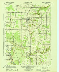
(5)- 1944 Map of Eden
 1944 Eden1944 Print · USGSCoastal Lake Erie and the inland valleys of Erie County are seen here during the mid-1940s. Genealogists can trace family footprints through the Cattaraugus Indian Reservation or old rail stops like Idlewood Sta and Lawton Sta.
 - 1944 Map of North Collins
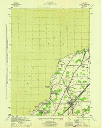
 1944 North Collins1944 Print · USGSSouthern Erie County is captured here in the mid-1940s, showing the intersection of rail infrastructure and the rural landscape. Genealogists can trace family locations along Mile Strip Road and explore sites like the Thomas Indian School or the Cem near North Collins.
 - 1944 Map of Angola
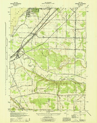
 1944 Angola1944 Print · USGSCoastal Erie County at the height of the war shows a landscape of busy rail corridors and growing lakeshore retreats. Trace the historic paths of the Pennsylvania and New York Central railroads as they pass through Angola and Jerusalem Corners.
 - 1944 Map of Farnham
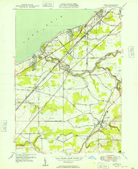
 1944 Farnham1944 Print · USGSWestern New York at the height of the war years shows a landscape of busy rail corridors and developing lakeside communities. Genealogists and local historians can trace family locations near Farnham, the borders of the Cattaraugus Indian Reservation, and the small settlement of Smiths Mills.
 - 1949 Map of Eden
 1949 Eden1949 Print · USGSCoastal Erie County and the agricultural townships of Hamburg and Eden are captured here in the late 1940s. Genealogists and local historians can trace the rail corridors of the Pennsylvania railroad and early lakefront developments like Wanakah and Highland-on-the-Lake.
End of results
Showing maps 1-5 of 5
Top cities near Evans
- Buffalo historical maps
- Cheektowaga historical maps
- Hamburg historical maps
- West Seneca historical maps
- Lackawanna historical maps
- Hamburg historical maps
See more
Top neighborhoods of Evans
- Pontiac historical maps
- North Evans historical maps
- Derby historical maps
- Jerusalem Corners historical maps
- Evans Center historical maps
- Highland-on-the-Lake historical maps
See more
Frequently asked questions
- What are the different types of historical maps available for Evans?
- What is the oldest map of Evans?
- Where can I purchase historical maps of Evans for my home or office?
- Where can I download high-res historical maps of Evans?
- Are there historical topographic maps available for Evans?
- Is there historical aerial imagery available for Evans?
- Where are historical maps of Evans sourced from?