Old Maps of Crown Point, New York
Explore 56 old maps of Crown Point, spanning from 1894 to today. These high-resolution historic maps reveal how streets, neighborhoods, landmarks, and natural features evolved over time — perfect for genealogy, metal detecting, research, and local history exploration.
What you can do with these maps:
- See how Crown Point changed over time: Compare historical maps to modern-day views to trace roads, homesites, rail lines & more.
- View detailed metadata: Each map includes creators, publishers, year, scale, and archive source.
- Overlay maps with satellite & LiDAR: Visualize the past alongside modern tools to explore terrain & human change.
- Trusted historical sources: Maps sourced from the USGS, Library of Congress, and other archives.
- Access maps your way: View online, download high-res files, or order prints for personal or research use.
Start exploring old maps of Crown Point to uncover forgotten places, hidden landmarks, and the deep history beneath your feet.
Crown Point, NY maps
(56)- 1894 Map of Elizabethtown
 1894 Elizabethtown1894 Print · USGSThe Adirondack high country of Essex County is captured here in the 1890s, showcasing a landscape defined by mountain peaks and the iron industry. Trace the early rail lines of the L. C. & M. R. R. into Mineville or locate vanished sites like Euba Mills and New Russia.2 unique versions available
 - 1894 Map of Port Henry
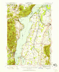
 1894 Port Henry1894 Print · USGSLake Champlain was a bustling corridor of steamships and rail lines during the 1890s, bridging the gap between New York and Vermont. Historians can trace the strategic layout of Crown Point, locate the French Fort Ruins, and explore industrial sites like Wadhams Mills.
 - 1894 Map of Ticonderoga, 1954 Print
 1894 Ticonderoga1954 Print · USGSLake Champlain and its strategic fortifications appear here in the 1890s as a landscape of iron mining and essential rail junctions. Trace the historic grounds of Ft. Ticonderoga Ruin and the rail corridors of the Delaware and Hudson RR through Crown Point and Orwell.2 unique versions available
 - 1895 Map of Elizabethtown
 1895 Elizabethtown1895 Print · USGSEssex County in the 1890s is shown here as a landscape of timber, iron ore, and river-valley hamlets. Genealogists and historians can trace the early rail corridor of the L.C. & M. R.R. or locate family sites in Mineville, New Russia, and Moriah Center.
 - 1895 Map of Paradox Lake, 1954 Print
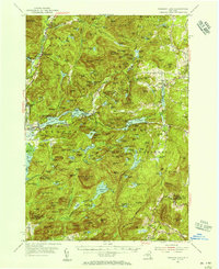
 1895 Paradox Lake1954 Print · USGSThe Adirondack high country near the turn of the century is captured here during the peak of its early industrial era. Trace the old mining works at Hammondville, the route of the Abandoned H. R. R., and remote mountain waters like Pharaoh Lake.
 - 1896 Map of Ticonderoga
 1896 Ticonderoga1896 Print · USGSThe strategic narrows of Lake Champlain and Lake George are shown here in the late nineteenth century, capturing the area's transition from military frontier to industrial corridor. Genealogists and historians can trace rail lines, steamer routes, and local landmarks like Ticonderoga Ruin, French Ch., and Burdicks Crossing.2 unique versions available
 - 1897 Map of Paradox Lake
 1897 Paradox Lake1897 Print · USGSThe eastern Adirondacks near the turn of the century show a rugged landscape of early iron-and-rail industry. Researchers can trace the C. P. and H. R. R. (Abandoned) rail line near Ironville and locate historic settlements like Hammondville and Chilson.10 unique versions available
 - 1898 Map of Port Henry
 1898 Port Henry1898 Print · USGSLake Champlain and its historic shores are captured in the late nineteenth century as steam and rail networks connected these borderlands. Researchers can locate the French Fort Ruins, trace the Central Vermont line, and explore old industrial sites like Wadhams Mills.10 unique versions available
 - 1901 Map of Elizabethtown
 1901 Elizabethtown1901 Print · USGSEssex County's high peaks and mining districts are captured here at the turn of the century, when the valley roads and mountain notches were the primary arteries of travel. Genealogists and historians can trace old community life in Elizabethtown, the industrial roots of Mineville, and the remote logging and mill sites at Euba Mills.9 unique versions available
 - 1902 Map of Ticonderoga
 1902 Ticonderoga1902 Print · USGSThe Champlain Valley at the start of the twentieth century is captured here in the borderlands of New York and Vermont. Researchers can trace the military grounds of Fort Ticonderoga, identify operations at the Iron Mine, and locate rural stations like Burdick Crossing.11 unique versions available
 - 1945 Map of Port Henry, 1958 Print
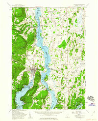
 1945 Port Henry1958 Print · USGSMid-century life along the Vermont and New York border is centered on the waters of Lake Champlain and its historic defenses. Researchers can trace the ruins of Fort Crown Point or locate family roots at Gage Cemetery and Smith School.5 unique versions available
 - 1947 Map of Port Henry
 1947 Port Henry1947 Print · USGSLake Champlain sits at the heart of this late 1940s survey of the New York and Vermont borderlands. Genealogists and local historians can trace legacy sites like the Fort St Frederic Ruins, the Rutland RR corridor, and a high density of country schools including Crane Sch and Smith Sch.2 unique versions available
 - 1950 Map of Glens Falls
 1950 Glens Falls1950 Print · USGSThe Adirondacks and the Green Mountains meet in this mid-century survey of the New York and Vermont borderlands. Researchers can trace the industrial rail corridors of the Rutland RR and Delaware & Hudson RR connecting Glens Falls, Rutland, and the shores of Lake George.
 - 1950 Map of Lake Champlain
 1950 Lake Champlain1950 Print · USGSThe Lake Champlain valley and its surrounding peaks are captured in detail during the late 1940s, showing the vital rail and road connections between New York and Vermont. Researchers can trace the routes of the Central Vermont Railway or locate old industrial centers like Mineville and Witherbee.2 unique versions available
 - 1950 Map of Crown Point, 1952 Print
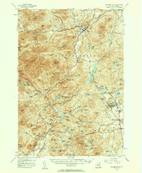
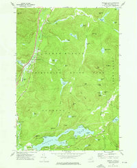
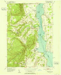 1950 Crown Point1952 Print · USGSThe mid-century shoreline of Lake Champlain is captured here, showing the transition from the Adirondacks into Vermont. Researchers can trace the Delaware and Hudson railroad and locate local landmarks like the Champlain Speedway and Sacred Heart Cem.4 unique versions available
 - 1950 Map of Ticonderoga, 1960 Print
 1950 Ticonderoga1960 Print · USGSThe Champlain Valley around the Vermont and New York border comes into focus just after the war, showing a landscape defined by its historic forts and rail lines. Genealogists and historians can trace family-named landmarks like Burdick Crossing, local schools such as Lake Sch, and old cemeteries including Lakeview Cem.3 unique versions available
 - 1953 Map of Paradox Lake, 1956 Print
 1953 Paradox Lake1956 Print · USGSThe Adirondack wilderness of the early fifties is preserved here, showing the balance between quiet settlements and the region's industrial past. Genealogists and historians can trace family locations near Ironville, St Nicholas Chapel, and the Schroon River Cem.5 unique versions available
 - 1955 Map of Elizabethtown, 1957 Print
 1955 Elizabethtown1957 Print · USGSThe Adirondack iron mining district and the high peaks of Essex County are captured here in the mid-fifties. Researchers can trace the industrial footprint of the Fisher Hill Iron Mine and the mining communities of Witherbee and Mineville alongside the wilderness of Giant Mtn.5 unique versions available
 - 1956 Map of Glens Falls, 1968 Print
 1956 Glens Falls1968 Print · USGSUpper New York and the Vermont mountains are captured here in the mid-fifties, showing the rugged rail-and-river network of the Northeast. Researchers can trace the paths of the Delaware and Hudson RR and Rutland RR as they wind through valley towns like Poultney and Whitehall.3 unique versions available
 - 1958 Map of Lake Champlain
 1958 Lake Champlain1958 Print · USGSThe Champlain Valley and surrounding high peaks are captured here in the late fifties, showcasing the cross-border region from the Adirondacks to the Green Mountains. Researchers can trace historic rail routes like the Rutland Railway or locate old valley settlements such as Keeseville and Vergennes.2 unique versions available
 - 1959 Map of Glens Falls
 1959 Glens Falls1959 Print · USGSUpper New York and Vermont are captured here during the late 1950s, a period of transition for these mountain communities. Researchers can trace the legacy of the region's river-and-rail economy through landmarks like Lake George, Saratoga Springs, and Killington Peak.2 unique versions available
 - 1962 Map of Lake Champlain, 1975 Print
 1962 Lake Champlain1975 Print · USGSLake Champlain and the high peaks of the Adirondacks and Green Mountains are captured here during the mid-twentieth century. Researchers can trace the industrial legacy of the Lyon Mountain Mine and the rail corridors of the Central Vermont RR and Delaware & Hudson RR.3 unique versions available
 - 1964 Map of Glens Falls
 1964 Glens Falls1964 Print · USGSThe tri-state borderlands of New York, Vermont, and New Hampshire appear here in the mid-1960s. Researchers can trace the rail routes of the Rutland RR and find historic sites like Ticonderoga and Saratoga National Historical Park.
 - 1973 Map of Eagle Lake, 1975 Print
 1973 Eagle Lake1975 Print · USGSEssex County in the early seventies shows a landscape where industrial heritage meets protected wilderness. Genealogists and historians can locate remote settlements like Ironville, old mining sites near Furnace Mtn, and landmarks along Eagle Lake.
 - 1973 Map of Paradox Lake, 1976 Print
 1973 Paradox Lake1976 Print · USGSThe Adirondack backcountry in the early seventies shows a landscape of deep-woods ponds and growing recreational hubs. Genealogists and hikers can trace old routes near North Hudson or locate family sites by Pine Ridge Cem and Schroon Falls.2 unique versions available
Showing maps 1-25 of 56
Top cities near Crown Point
- Ticonderoga historical maps
- Moriah historical maps
- Chester historical maps
- Ferrisburgh historical maps
- Schroon historical maps
- Horicon historical maps
See more
Top neighborhoods of Crown Point
- Ironville historical maps
- Cold Spring Park historical maps
- Crown Point Center historical maps
- Burdick Crossing historical maps
- Factoryville historical maps
Frequently asked questions
- What are the different types of historical maps available for Crown Point?
- What is the oldest map of Crown Point?
- Where can I purchase historical maps of Crown Point for my home or office?
- Where can I download high-res historical maps of Crown Point?
- Are there historical topographic maps available for Crown Point?
- Is there historical aerial imagery available for Crown Point?
- Where are historical maps of Crown Point sourced from?