
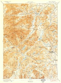
1894 Map of Elizabethtown
USGS Topo · Published 1894About this map
Elizabethtown serves as the focal point of this late 19th-century study, situated at the confluence of the Boquet River and its several mountain-fed tributaries. The landscape is defined by the high elevations of the Green Mountain range, including prominent peaks like Hurricane Mtn. and Giant Mtn.. In the southeastern corner, the industrial character of the era is evident at Mineville, where the L. C. & M. R. R. serves the local iron mining operations. Small settlements and specialized mills, such as Euba Mills and New Russia, dot the narrow river valleys, showing the nineteenth-century reliance on water power and timber. Dozens of small alpine water bodies like Giant Washbowl and Cranberry Pond reflect the intricate drainage patterns that defined local land use before the expansion of modern infrastructure.
Find a feature on this map
120 named features on this map. Tap any name to fly to it.
Don’t see what you’re looking for? This feature index may not catch every label — zoom into the map to look around manually.
Map Details
Editions of this 1894 Elizabethtown Map
2 editions found
Other maps of this area

1894 · Port Henry
USGS Topo · 1:62,500

1894 · Ticonderoga
USGS Topo · 1:62,500

1895 · Willsboro
USGS Topo · 1:62,500

1895 · Elizabethtown
USGS Topo · 1:62,500

1895 · Mt. Marcy
USGS Topo · 1:62,500

1895 · Ausable
USGS Topo · 1:62,500

1895 · Paradox Lake
USGS Topo · 1:62,500

1896 · Lake Placid
USGS Topo · 1:62,500

1896 · Ticonderoga
USGS Topo · 1:62,500

1897 · Paradox Lake
USGS Topo · 1:62,500