
1895 Map of Mt. Marcy
USGS Topo · Published 1895About this map
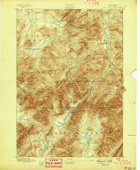
Mt. Marcy towers over the high peaks of Essex County in this late-nineteenth-century survey of the Adirondacks. The landscape is defined by the extensive Adirondack Mountain Reserve, a region already emerging as a destination for wilderness exploration. To the north, the small settlement of North Elba sits near the headwaters of the West Br. Ausable River, while the Adirondack Lodge serves as a remote outpost for early mountaineers. The map captures the complex hydrology of the high country, from the high-altitude Lake Tear to the waters of Lake Colden and Avalanche Lake. In the east, the village of Keene Valley and the locality of Beede provide access points to the interior, where peaks like Gothic Mt. and Mt. Haystack rise sharply from the river valleys. The survey records a period when these summits were being meticulously measured and the foundations of the state park system were being established.
Find a feature on this map
98 named features on this map. Tap any name to fly to it.
Don’t see what you’re looking for? This feature index may not catch every label — zoom into the map to look around manually.
Map Details
Editions of this 1895 Mt. Marcy Map
2 editions found
Other maps of this area

1894 · Elizabethtown
USGS Topo · 1:62,500

1895 · Elizabethtown
USGS Topo · 1:62,500

1895 · Ausable
USGS Topo · 1:62,500

1895 · Paradox Lake
USGS Topo · 1:62,500

1896 · Lake Placid
USGS Topo · 1:62,500

1897 · Paradox Lake
USGS Topo · 1:62,500

1897 · Schroon Lake
USGS Topo · 1:62,500

1898 · Newcomb
USGS Topo · 1:62,500

1898 · Lake Placid
USGS Topo · 1:62,500

1901 · Newcomb
USGS Topo · 1:62,500