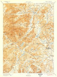
1894 Map of Elizabethtown
USGS Topo · Published 1894About this map
Elizabethtown serves as the focal point for this 1892 survey, which captures the rugged Adirondack landscape before the widespread modernization of the 20th century. The settlement pattern follows the narrow valleys, with New Russia and Euba Mills established along the banks of the Bouquet River. To the east, the industrial character of the region is evident at Mineville, where the L. C. & M. R. R. railroad winds through the foothills of Belfry Hill and Barton Hill to support the local mining economy.
Find a feature on this map
115 named features on this map. Tap any name to fly to it.
Don’t see what you’re looking for? This feature index may not catch every label — zoom into the map to look around manually.
Map Details
Editions of this 1894 Elizabethtown Map
2 editions found
Other maps of this area

1894 · Elizabethtown
USGS Topo · 1:62,500

1894 · Port Henry
USGS Topo · 1:62,500

1894 · Ticonderoga
USGS Topo · 1:62,500

1895 · Willsboro
USGS Topo · 1:62,500

1895 · Elizabethtown
USGS Topo · 1:62,500

1895 · Mt. Marcy
USGS Topo · 1:62,500

1895 · Ausable
USGS Topo · 1:62,500

1895 · Paradox Lake
USGS Topo · 1:62,500

1896 · Lake Placid
USGS Topo · 1:62,500

1896 · Ticonderoga
USGS Topo · 1:62,500