
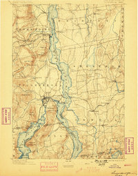
1896 Map of Ticonderoga
USGS Topo · Published 1896About this map
Ticonderoga Ruin and Fort Ticonderoga stand at the strategic narrows of Lake Champlain during the mid-1890s, marking the historic transition between New York and Vermont. The map reveals a landscape defined by 19th-century transit networks, where the Central Vermont R. R. and Delaware and Hudson Canal Co. R. R. converge near Addison Junction. This rail infrastructure is complemented by the Route of Steamers plying the lake waters between points like Larrabees Point and Burdicks Crossing. To the west, the rugged slopes of Mt. Defiance and Cooks Mountain overlook the industrial activity of the era, including iron ore extraction near Crown Point Center. The settlement patterns in Shoreham and Bridport reflect an established agricultural and social community, evidenced by the French Ch. and local Fletcher Sch..
Find a feature on this map
101 named features on this map. Tap any name to fly to it.
Don’t see what you’re looking for? This feature index may not catch every label — zoom into the map to look around manually.
Map Details
Editions of this 1896 Ticonderoga Map
2 editions found
Other maps of this area

1893 · Whitehall
USGS Topo · 1:62,500

1894 · Elizabethtown
USGS Topo · 1:62,500

1894 · Port Henry
USGS Topo · 1:62,500

1894 · Ticonderoga
USGS Topo · 1:62,500

1895 · Whitehall
USGS Topo · 1:62,500

1895 · Elizabethtown
USGS Topo · 1:62,500

1895 · Paradox Lake
USGS Topo · 1:62,500

1895 · Castleton
USGS Topo · 1:62,500

1897 · Bolton
USGS Topo · 1:62,500

1897 · Paradox Lake
USGS Topo · 1:62,500