1970s Maps of Fulton County, New York
Explore 8 historic maps of Fulton County from the 1970s. These maps offer a rare glimpse into what life looked like during the 1970s — showing old roads, neighborhoods, homes, and landmarks that have changed or disappeared over time.
Whether you're researching your family's past, planning a metal detecting trip, or studying how Fulton County's landscape evolved across the 1970s, these high-resolution maps are a powerful tool for exploring the history of this region.
- Focus on a specific era: All maps on this page are from the 1970s, giving you a focused view of this time period.
- See what’s changed: Compare century-old streets, trails, and buildings to today's modern landscape using overlays and satellite layers.
- Research with precision: Use these maps for genealogy, historical research, land use analysis, or educational projects.
- View, download, or print: Maps are fully viewable online in high resolution, and can be downloaded or printed for your own records.
Start exploring Fulton County's history through authentic maps from the 1970s. This is your window into the past.
Fulton County, NY maps
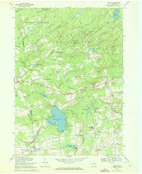
(8)- 1970 Map of Northville, 1972 Print
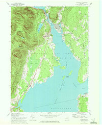 1970 Northville1972 Print · USGSFulton County’s lakeside communities are captured here in the early seventies, showcasing the developed shoreline of the Great Sacandaga Lake. Genealogists can locate family landmarks such as Gifford Valley Cem, Sweets Crossing, and the historic settlement of Fish House.2 unique versions available
 - 1970 Map of Edinburg, 1972 Print
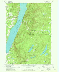 1970 Edinburg1972 Print · USGSSaratoga County life in the early seventies centers on the shores of Great Sacandaga Lake and the southern Adirondacks. Researchers can locate old family landmarks like Partridge Cem, Consolidated School No 1, and the Plateau Landing Field.2 unique versions available
 - 1970 Map of Gloversville, 1972 Print
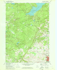
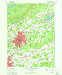 1970 Gloversville1972 Print · USGSGloversville and Johnstown are shown in detail during the early 1970s, from the urban manufacturing core to the Adirondack foothills. Trace local history at the F J & G RR, Tryon State School for Boys, and Prospect Hill Cem.
 - 1970 Map of Broadalbin, 1972 Print
 1970 Broadalbin1972 Print · USGSThe foothills of the Adirondacks meet the southern shores of the lake during the early seventies, showing a landscape of lakeside points and inland hamlets. Researchers can trace family sites at Perth Cem, the route of the Fonda Johnstown and Gloversville rail, and local industry at Stever Mill.
 - 1970 Map of Galway, 1972 Print
 1970 Galway1972 Print · USGSSaratoga County's southern Adirondack foothills were a landscape of established hamlets and family crossroads during the early seventies. Trace local lineages and old property lines through namesake locations like Whiteside Corners, Hooseville, and the Zion Hill Cemetery.
 - 1970 Map of Peck Lake, 1972 Print
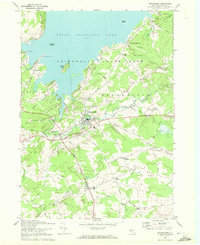
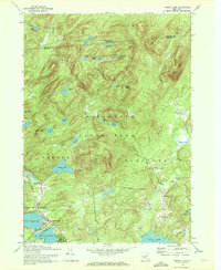
 1970 Peck Lake1972 Print · USGSThe Fulton County countryside in the 1970s shows the meeting of the Adirondack wilderness and the growing outskirts of Gloversville. Locate family landmarks like Eppie Corners, the Boshart Cem, and North Bush.
 - 1970 Map of Caroga Lake, 1972 Print
 1970 Caroga Lake1972 Print · USGSThe southern Adirondacks come into focus during the early 1970s, showing a landscape defined by recreational camps and high-country hamlets. Researchers can trace local heritage through St Josephs Cemetery, the Union School at Wheelerville, and the lakeside community at Caroga Lake.
 - 1970 Map of Jackson Summit, 1972 Print
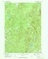 1970 Jackson Summit1972 Print · USGSThe Adirondack foothills in the early 1970s show a landscape of isolated mountain settlements and expansive vlys. Genealogists and hikers can trace the old road networks through Lindsley Corners and find landmarks like Buttermilk Falls or the Jackson Summit Reservoir.2 unique versions available
End of results
Showing maps 1-8 of 8
Top cities of Fulton County
- Gloversville historical maps
- Johnstown historical maps
- Johnstown historical maps
- Mayfield historical maps
- Broadalbin historical maps
- Perth historical maps
See more
Frequently asked questions
- What are the different types of historical maps available for Fulton County?
- What is the oldest map of Fulton County?
- Where can I purchase historical maps of Fulton County for my home or office?
- Where can I download high-res historical maps of Fulton County?
- Are there historical topographic maps available for Fulton County?
- Is there historical aerial imagery available for Fulton County?
- Where are historical maps of Fulton County sourced from?