Old Maps of Johnstown, New York for Metal Detecting
Plan your next treasure hunt with 47 historic maps of Johnstown. Find old homesites, ghost towns, trails, and gathering spots that may be lost to time — perfect for identifying promising metal detecting locations.
- Locate forgotten sites: Uncover places like long-lost settlements, abandoned rail lines, or gathering spots.
- Plan better hunts: Use map overlays combined with LiDAR or satellite views to narrow in on historically rich areas.
- Made for detectorists: Thousands of hobbyists use these maps to discover relics, coins, and hidden history.
Use these historic maps to boost your research and find new opportunities beneath the surface of Johnstown.
Johnstown, NY maps
(47)- 1896 Map of Fonda
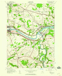
 1896 Fonda1896 Print · USGSThe Mohawk Valley was a technological corridor in the 1890s, defined by the convergence of major rail lines and the Erie Canal. Genealogists and historians can trace the old post offices and hamlet life at Yatesville Randall P.O., Auriesville, and Rural Grove.
 - 1898 Map of Fonda
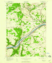
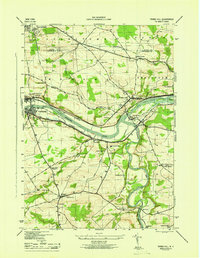
 1898 Fonda1898 Print · USGSThe Mohawk Valley at the close of the 19th century was a powerhouse of transit and industry. Genealogists and historians can trace the bustling Erie Canal corridor through Fonda, the upland reaches of Charleston, and the path of the West Shore R. R.
 - 1902 Map of Fonda
 1902 Fonda1902 Print · USGSThe Mohawk Valley at the close of the nineteenth century reveals a critical junction of the Erie Canal and major railroads. Genealogists and historians can trace old homesteads and local centers like Auriesville, Sammonsville, and the remote Charleston Four Corners.8 unique versions available
 - 1903 Map of Gloversville
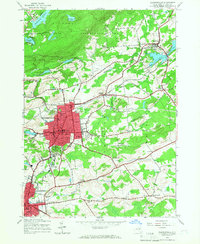
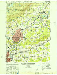
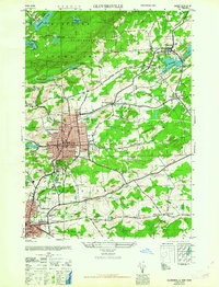
 1903 Gloversville1903 Print · USGSGloversville and Johnstown anchor this turn-of-the-century survey as the region's industrial heart, surrounded by the growing Adirondack resort and timber lands. Genealogists and historians can trace the Electric R.R. or locate historic markers like the Battle Monument and old hamlets like Bleecker Center.8 unique versions available
 - 1943 Map of Gloversville
 1943 Gloversville1943 Print · USGSGloversville and Johnstown serve as the industrial anchors of this Adirondack foothills region during the early twentieth century. Genealogists and historians can trace the paths of the Electric R. R. and locate family landmarks like Kingsboro, Bleecker, and the Battle Monument.
 - 1944 Map of Tribes Hill, 1959 Print
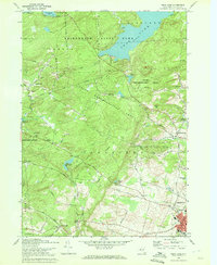
 1944 Tribes Hill1959 Print · USGSThe Mohawk Valley's transition into the interstate era is documented here as the new thruway cuts across traditional canal and rail corridors. Genealogists and local historians can trace family-named sites like Wycoff Cem, Switzer Hill, and the Cadaughrity Sch.2 unique versions available
 - 1944 Map of Randall, 1959 Print
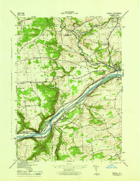
 1944 Randall1959 Print · USGSThe Mohawk Valley's vital transportation corridor is captured here in the mid-1940s, showing the early integration of the Thruway alongside historic water and rail routes. Genealogists can trace family names at Sammons Cem, Winnie Sch, and the Tekakwitha Friary.3 unique versions available
 - 1945 Map of Gloversville, 1966 Print
 1945 Gloversville1966 Print · USGSGloversville and Johnstown are shown in high detail during the mid-forties, capturing the industrial and civic heart of Fulton County. Researchers can trace family roots at St Patricks Cem, locate the old County Home, or find vanished schoolhouses like Hale Mills School.
 - 1946 Map of Randall
 1946 Randall1946 Print · USGSThe Mohawk Valley in the mid-1940s displays a landscape shaped by centuries of transport, from the river and rails to the canal system. Researchers can trace ancestral sites like Sammons Cem, the Tekakwitha Friary, and several rural schoolhouses.
 - 1946 Map of Gloversville
 1946 Gloversville1946 Print · USGSFulton County industrial centers and rural outskirts are captured here just after the war. Local historians can trace the F J & G RR through Gloversville, find family plots at Prospect Hill Cem, or locate rural landmarks like Dennies Crossing.
 - 1946 Map of Peck Lake
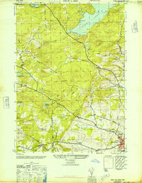 1946 Peck Lake1946 Print · USGSFulton County settlements and the southern Adirondacks are captured here in the years following the war. Researchers can trace the rural networks around Peck Lake, locating family burial sites like Boshart Cem and early schools including Clip Hill Sch.
 - 1946 Map of Tribes Hill
 1946 Tribes Hill1946 Print · USGSThe Mohawk Valley in the mid-1940s reveals a landscape shaped by centuries of transit and settlement along the water. Researchers can trace the path of the Abandoned Erie Canal or find family landmarks like the Wycoff Cem and Cadaughrity Sch.
 - 1948 Map of Binghamton, 1980 Print
 1948 Binghamton1980 Print · USGSCentral New York and the Southern Tier thrive in the late 1940s as a hub of rail traffic and mountain industry. Researchers can trace historic transit lines like the Erie Railroad through Binghamton or find old valley settlements near Oneonta and Delhi.
 - 1950 Map of Binghamton
 1950 Binghamton1950 Print · USGSBinghamton and the surrounding Southern Tier are shown in the mid-century era, highlighting the intricate rail and river networks that drove local industry. Researchers can trace the path of the Erie Railroad and locate landmarks from Otsego Lake to Sidney Mountain.2 unique versions available
 - 1950 Map of Utica, 1951 Print
 1950 Utica1951 Print · USGSCentral New York in the post-war era showcases the industrial Mohawk Valley and the pristine Adirondack interior. Researchers can trace transportation networks like the New York Central Railroad and find early Cold War sites such as Griffiss Air Force Base.
 - 1957 Map of Utica
 1957 Utica1957 Print · USGSCentral New York and the Adirondack foothills are captured here in the mid-fifties, showing a landscape defined by the Mohawk River corridor and the growing highway system. Genealogists and researchers can trace the rail lines of the New York Central and locate communities from Lowville to Gloversville.
 - 1958 Map of Binghamton
 1958 Binghamton1958 Print · USGSCentral New York in the late fifties was a network of manufacturing cities and river valleys connected by vital rail lines. Genealogists and historians can trace family roots in Oneonta, Norwich, and Cooperstown or locate long-standing farms along Schoharie Creek.
 - 1962 Map of Peck Lake
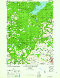 1962 Peck Lake1962 Print · USGSFulton County’s southern Adirondack foothills were well-established rural communities by the mid-1940s. Genealogists and local historians can trace family sites like Kecks Center Cem or follow the old Turnpike Road to the Wemple Sch.
 - 1962 Map of Utica
 1962 Utica1962 Print · USGSCentral New York and the Adirondack wilderness are captured here during the mid-century era of highway and industrial expansion. Genealogists and historians can trace the development of the New York State Thruway and local rail lines connecting Utica, Rome, and Gloversville.3 unique versions available
 - 1963 Map of Gloversville
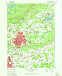
 1963 Gloversville1963 Print · USGSGloversville and Johnstown stand at the height of their industrial era, linked by the Fonda Johnstown and Gloversville RR. Researchers can trace family roots at Fern Dale Cem or locate old neighborhood landmarks like Lexington Sch and the Littauer Hospital.
 - 1963 Map of Binghamton
 1963 Binghamton1963 Print · USGSThe Southern Tier and Catskill peaks are shown in the early sixties as new reservoirs reshaped the valleys. Trace historic rail corridors like the Erie Lackawanna RR and explore lakeside settlements such as Cooperstown and Oneonta.
 - 1964 Map of Utica
 1964 Utica1964 Print · USGSCentral New York and the high wilderness of the Adirondacks are captured here during the post-war era of infrastructure expansion. Researchers can trace the development of the New York State Thruway alongside historic corridors like the Oneida Lake (Barge Canal Route) and the N. Y. Central railroad.
 - 1967 Map of Utica
 1967 Utica1967 Print · USGSCentral New York's industrial Mohawk Valley meets the Adirondack wilderness in the 1960s, showing the region's transition from manufacturing hubs to state-managed parklands. Trace historic settlements and sites like Griffiss Air Force Base, Colgate University, and the Lyons Falls Paper Mill.
 - 1970 Map of Gloversville, 1972 Print
 1970 Gloversville1972 Print · USGSGloversville and Johnstown are shown in detail during the early 1970s, from the urban manufacturing core to the Adirondack foothills. Trace local history at the F J & G RR, Tryon State School for Boys, and Prospect Hill Cem.
 - 1970 Map of Peck Lake, 1972 Print
 1970 Peck Lake1972 Print · USGSThe Fulton County countryside in the 1970s shows the meeting of the Adirondack wilderness and the growing outskirts of Gloversville. Locate family landmarks like Eppie Corners, the Boshart Cem, and North Bush.
Showing maps 1-25 of 47
Top cities near Johnstown
- Amsterdam historical maps
- Gloversville historical maps
- Johnstown historical maps
- Mayfield historical maps
- Duanesburg historical maps
- Amsterdam historical maps
See more
Top neighborhoods of Johnstown
Frequently asked questions
- What are the different types of historical maps available for Johnstown?
- What is the oldest map of Johnstown?
- Where can I purchase historical maps of Johnstown for my home or office?
- Where can I download high-res historical maps of Johnstown?
- Are there historical topographic maps available for Johnstown?
- Is there historical aerial imagery available for Johnstown?
- Where are historical maps of Johnstown sourced from?