1940s Maps of Mayfield, New York
Explore 9 historic maps of Mayfield from the 1940s. These maps offer a rare glimpse into what life looked like during the 1940s — showing old roads, neighborhoods, homes, and landmarks that have changed or disappeared over time.
Whether you're researching your family's past, planning a metal detecting trip, or studying how Mayfield's landscape evolved across the 1940s, these high-resolution maps are a powerful tool for exploring the history of this region.
- Focus on a specific era: All maps on this page are from the 1940s, giving you a focused view of this time period.
- See what’s changed: Compare century-old streets, trails, and buildings to today's modern landscape using overlays and satellite layers.
- Research with precision: Use these maps for genealogy, historical research, land use analysis, or educational projects.
- View, download, or print: Maps are fully viewable online in high resolution, and can be downloaded or printed for your own records.
Start exploring Mayfield's history through authentic maps from the 1940s. This is your window into the past.
Mayfield, NY maps
(9)- 1943 Map of Gloversville
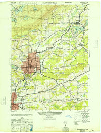
 1943 Gloversville1943 Print · USGSGloversville and Johnstown serve as the industrial anchors of this Adirondack foothills region during the early twentieth century. Genealogists and historians can trace the paths of the Electric R. R. and locate family landmarks like Kingsboro, Bleecker, and the Battle Monument.
 - 1945 Map of Northville, 1962 Print
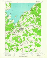
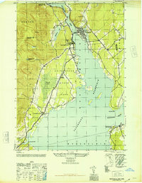
 1945 Northville1962 Print · USGSThe foothills of the Adirondacks meet the expanding reservoir in the mid-1940s, showing the vital connections between mountain valleys and the river. Genealogists can locate family burial sites at King Cem and Gifford Valley Cem or trace the early layout of Northville and Fish House.
 - 1945 Map of Jackson Summit, 1963 Print
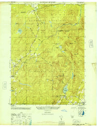
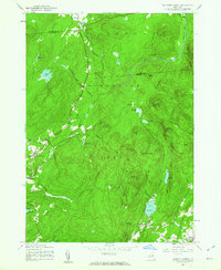 1945 Jackson Summit1963 Print · USGSThe southern Adirondacks at the close of the second World War reveal a landscape of mountain peaks and isolated hamlets. Family historians can locate specific burial sites at Bleecker Cem and trace old routes through Lindsley Corners or Ernst Corners.
 - 1945 Map of Broadalbin, 1963 Print
 1945 Broadalbin1963 Print · USGSFulton County settlements and the southern reaches of the Adirondack Park are captured here just after the war. Family researchers can trace ancestors through namesake locations like Honeywell Corners, Yates Cem, and rural schoolhouses including Black Street Sch.
 - 1945 Map of Gloversville, 1966 Print
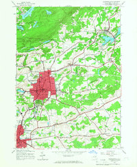 1945 Gloversville1966 Print · USGSGloversville and Johnstown are shown in high detail during the mid-forties, capturing the industrial and civic heart of Fulton County. Researchers can trace family roots at St Patricks Cem, locate the old County Home, or find vanished schoolhouses like Hale Mills School.
 - 1946 Map of Broadalbin
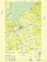 1946 Broadalbin1946 Print · USGSFulton County appears at the edge of the Adirondacks just after the war, showing the local impact of the Sacandaga Reservoir. Researchers can trace rural school districts like Black Street Sch and historic transport lines including the Fonda Johnstown and Gloversville.
 - 1946 Map of Gloversville
 1946 Gloversville1946 Print · USGSFulton County industrial centers and rural outskirts are captured here just after the war. Local historians can trace the F J & G RR through Gloversville, find family plots at Prospect Hill Cem, or locate rural landmarks like Dennies Crossing.
 - 1946 Map of Jackson Summit
 1946 Jackson Summit1946 Print · USGSAdirondack State Park and the rural highlands of Fulton County are shown here just after the war. Researchers can locate small mountain settlements like Jackson Summit and Lindsley Corners, as well as family-history markers such as the Bleeker Cem and Berry Cem.
 - 1946 Map of Northville
 1946 Northville1946 Print · USGSThe southern Adirondacks at the conclusion of the second World War reveal a landscape shaped by the new reservoir and traditional rail lines. Researchers can trace the F J & G RR through Sacandaga Park and locate historic burial sites like Christie Cem and King Cem.
End of results
Showing maps 1-9 of 9
Top cities near Mayfield
- Glenville historical maps
- West Glenville historical maps
- Amsterdam historical maps
- Gloversville historical maps
- Johnstown historical maps
- Johnstown historical maps
See more
Top neighborhoods of Mayfield
- Progress historical maps
- Red Bunch Corners historical maps
- Riceville historical maps
- Broadalbin Junction historical maps
- Munsonville historical maps
- Dennies Hollow historical maps
See more
Frequently asked questions
- What are the different types of historical maps available for Mayfield?
- What is the oldest map of Mayfield?
- Where can I purchase historical maps of Mayfield for my home or office?
- Where can I download high-res historical maps of Mayfield?
- Are there historical topographic maps available for Mayfield?
- Is there historical aerial imagery available for Mayfield?
- Where are historical maps of Mayfield sourced from?