1950s Maps of Alexander, New York
Explore 5 historic maps of Alexander from the 1950s. These maps offer a rare glimpse into what life looked like during the 1950s — showing old roads, neighborhoods, homes, and landmarks that have changed or disappeared over time.
Whether you're researching your family's past, planning a metal detecting trip, or studying how Alexander's landscape evolved across the 1950s, these high-resolution maps are a powerful tool for exploring the history of this region.
- Focus on a specific era: All maps on this page are from the 1950s, giving you a focused view of this time period.
- See what’s changed: Compare century-old streets, trails, and buildings to today's modern landscape using overlays and satellite layers.
- Research with precision: Use these maps for genealogy, historical research, land use analysis, or educational projects.
- View, download, or print: Maps are fully viewable online in high resolution, and can be downloaded or printed for your own records.
Start exploring Alexander's history through authentic maps from the 1950s. This is your window into the past.
Alexander, NY maps
(5)- 1950 Map of Batavia
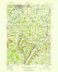 1950 Batavia1950 Print · USGSWestern New York at the mid-century shows a bustling landscape of rail hubs and rural crossroads. Researchers can trace the heritage of Batavia and Wyoming while locating local landmarks like the Pioneer Salt Well, Bethany Ch, and the Fairgrounds.
 - 1950 Map of Batavia South, 1952 Print
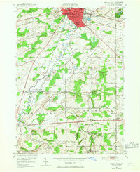 1950 Batavia South1952 Print · USGSThe Genesee County countryside south of Batavia in the early fifties was a busy junction of four major railroads. Genealogists and local historians can trace the paths between rural hamlets like Linden, Brookville, and Bethany Center, or locate landmarks such as Jackson Sch and the County Home.3 unique versions available
 - 1951 Map of Dale
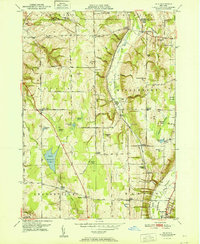 1951 Dale1951 Print · USGSMid-century Wyoming County life is centered on the deep ravines and rail lines carved by Tonawanda Creek. Genealogists can trace early rural neighborhoods through family-named landmarks like Williams Corners, Brainard Cem, and School No 4.
 - 1951 Map of Attica
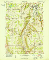 1951 Attica1951 Print · USGSWestern New York's Wyoming County is surveyed here in the early postwar years, centered on the vital rail hub of Attica. Genealogists and historians can trace the rural landscape through family-named sites and landmarks like Danley Corners, St Vincent Cem, and the County Home.
 - 1951 Map of Alexander
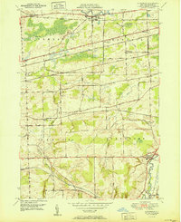 1951 Alexander1951 Print · USGSGenesee County's agricultural and rail-connected landscape is preserved here in the mid-twentieth century. Researchers can trace historic property access along Wortendyke Road and locate rural hubs like Sawens or Maple Hill Cem.
End of results
Showing maps 1-5 of 5
Top cities near Alexander
- Batavia historical maps
- Alden historical maps
- Newstead historical maps
- LeRoy historical maps
- Royalton historical maps
- Batavia historical maps
See more
Top neighborhoods of Alexander
- Brookville historical maps
- North Alexander historical maps
- East Alexander historical maps
- Ray historical maps
- Alexander historical maps
Frequently asked questions
- What are the different types of historical maps available for Alexander?
- What is the oldest map of Alexander?
- Where can I purchase historical maps of Alexander for my home or office?
- Where can I download high-res historical maps of Alexander?
- Are there historical topographic maps available for Alexander?
- Is there historical aerial imagery available for Alexander?
- Where are historical maps of Alexander sourced from?