Old Maps of Piseco, Arietta
Explore 17 old maps of Piseco, spanning from 1904 to today. These high-resolution historic maps reveal how streets, neighborhoods, landmarks, and natural features evolved over time — perfect for genealogy, metal detecting, research, and local history exploration.
What you can do with these maps:
- See how Piseco changed over time: Compare historical maps to modern-day views to trace roads, homesites, rail lines & more.
- View detailed metadata: Each map includes creators, publishers, year, scale, and archive source.
- Overlay maps with satellite & LiDAR: Visualize the past alongside modern tools to explore terrain & human change.
- Trusted historical sources: Maps sourced from the USGS, Library of Congress, and other archives.
- Access maps your way: View online, download high-res files, or order prints for personal or research use.
Start exploring old maps of Piseco to uncover forgotten places, hidden landmarks, and the deep history beneath your feet.
Piseco, Arietta maps
(17)- 1904 Map of Piseco Lake
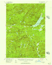
 1904 Piseco Lake1904 Print · USGSThe central Adirondacks in the early 1900s centered on the waters of Piseco Lake and the winding West Canada Creek. Local historians can trace early outposts and settlements like Hoffmeister, Rudeston, and the isolated Mountain House.
 - 1906 Map of Piseco Lake
 1906 Piseco Lake1906 Print · USGSThe Adirondack wilderness of the early twentieth century comes into focus through this survey of the high-country lake district. Researchers can find logging-era outposts and early resorts like Mountain House, Rudeston, and the remote Powley Place.7 unique versions available
 - 1908 Map of Piseco Lake, 1918 Print
 1908 Piseco Lake1918 Print · USGSThe southern Adirondacks at the turn of the century appear as a network of isolated homesteads and family camps. Trace early settlements like Piseco and Hoffmeister or find remote landmarks such as Mountain House, Powley Place, and Clockmill Corners.
 - 1950 Map of Utica, 1951 Print
 1950 Utica1951 Print · USGSCentral New York in the post-war era showcases the industrial Mohawk Valley and the pristine Adirondack interior. Researchers can trace transportation networks like the New York Central Railroad and find early Cold War sites such as Griffiss Air Force Base.
 - 1954 Map of Piseco Lake, 1957 Print
 1954 Piseco Lake1957 Print · USGSMid-century Hamilton County is captured here in detail, showcasing the high-elevation settlements and lakes of the southern Adirondacks. Genealogists and historians can trace family locations and remote sites like Morehouseville, Shaker Place, and the Spruce Hill Cem.5 unique versions available
 - 1957 Map of Utica
 1957 Utica1957 Print · USGSCentral New York and the Adirondack foothills are captured here in the mid-fifties, showing a landscape defined by the Mohawk River corridor and the growing highway system. Genealogists and researchers can trace the rail lines of the New York Central and locate communities from Lowville to Gloversville.
 - 1962 Map of Utica
 1962 Utica1962 Print · USGSCentral New York and the Adirondack wilderness are captured here during the mid-century era of highway and industrial expansion. Genealogists and historians can trace the development of the New York State Thruway and local rail lines connecting Utica, Rome, and Gloversville.3 unique versions available
 - 1964 Map of Utica
 1964 Utica1964 Print · USGSCentral New York and the high wilderness of the Adirondacks are captured here during the post-war era of infrastructure expansion. Researchers can trace the development of the New York State Thruway alongside historic corridors like the Oneida Lake (Barge Canal Route) and the N. Y. Central railroad.
 - 1967 Map of Utica
 1967 Utica1967 Print · USGSCentral New York's industrial Mohawk Valley meets the Adirondack wilderness in the 1960s, showing the region's transition from manufacturing hubs to state-managed parklands. Trace historic settlements and sites like Griffiss Air Force Base, Colgate University, and the Lyons Falls Paper Mill.
 - 1985 Map of Gloversville, 1986 Print
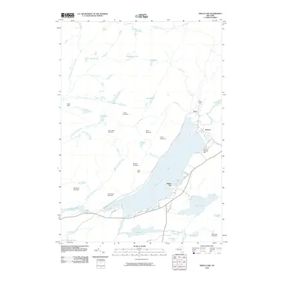
 1985 Gloversville1986 Print · USGSThe southern Adirondacks meet the Mohawk Valley industrial corridor during the mid-eighties, showcasing a landscape of high-country lakes and riverside manufacturing towns. Trace the historical alignment of the Erie Canal and Conrail lines or locate landmarks like the Herkimer Home State Historic Site.2 unique versions available
 - 1990 Map of Piseco Lake
 1990 Piseco Lake1990 Print · USGSHamilton County's mountain wilderness and quiet lakefront communities are captured here in the 1990s. Genealogists and researchers can trace the small settlements of Piseco and Rudeston alongside landmarks like Higgins Bay and the local Cem.2 unique versions available
 - 1997 Map of Piseco Lake
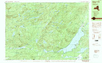
 1997 Piseco Lake1997 Print · USGSThe Adirondack forest preserve in the late nineties centers on the waters of Piseco Lake and the Metcalf Range. Researchers can trace the layout of Piseco, Rudeston, and Higgins Bay, or locate remote sites like Mountain Home and the local Cem.
 - 2010 Map of Piseco Lake, 2010 Print
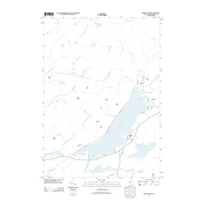
 2010 Piseco Lake2010 Print · USGSCovers Piseco, including Arietta, Rudeston, and other nearby areas
 - 2013 Map of Piseco Lake, 2013 Print
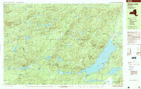
 2013 Piseco Lake2013 Print · USGSCovers Piseco, including Arietta, Rudeston, and other nearby areas
 - 2016 Map of Piseco Lake, 2016 Print
 2016 Piseco Lake2016 Print · USGSCovers Piseco, including Arietta, Rudeston, and other nearby areas
 - 2019 Map of Piseco Lake, 2019 Print
 2019 Piseco Lake2019 Print · USGSCovers Piseco, including Arietta, Rudeston, and other nearby areas
 - 2023 Map of Piseco Lake, 2023 Print
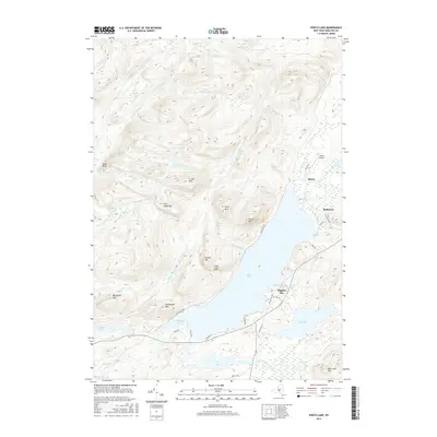
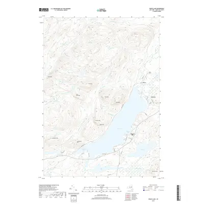
 2023 Piseco Lake2023 Print · USGSThe Adirondack wilderness around Piseco Lake is captured here in the early twenty-first century, showing a landscape shaped by water and woods. Local historians and hikers can trace the Northville-Placid Trl and find landmarks like Piseco Airport and Higgins Bay.
End of results
Showing maps 1-17 of 17
Top cities near Piseco
- Salisbury historical maps
- Indian Lake historical maps
- Caroga historical maps
- Lake Pleasant historical maps
- Wells historical maps
- Bleecker historical maps
See more
Frequently asked questions
- What are the different types of historical maps available for Piseco?
- What is the oldest map of Piseco?
- Where can I purchase historical maps of Piseco for my home or office?
- Where can I download high-res historical maps of Piseco?
- Are there historical topographic maps available for Piseco?
- Is there historical aerial imagery available for Piseco?
- Where are historical maps of Piseco sourced from?