1980s Maps of Woods, Long Lake
Explore 2 historic maps of Woods from the 1980s. These maps offer a rare glimpse into what life looked like during the 1980s — showing old roads, neighborhoods, homes, and landmarks that have changed or disappeared over time.
Whether you're researching your family's past, planning a metal detecting trip, or studying how Woods's landscape evolved across the 1980s, these high-resolution maps are a powerful tool for exploring the history of this region.
- Focus on a specific era: All maps on this page are from the 1980s, giving you a focused view of this time period.
- See what’s changed: Compare century-old streets, trails, and buildings to today's modern landscape using overlays and satellite layers.
- Research with precision: Use these maps for genealogy, historical research, land use analysis, or educational projects.
- View, download, or print: Maps are fully viewable online in high resolution, and can be downloaded or printed for your own records.
Start exploring Woods's history through authentic maps from the 1980s. This is your window into the past.
Woods, Long Lake maps
(2)- 1985 Map of Raquette Lake, 1986 Print
 1985 Raquette Lake1986 Print · USGSThe central Adirondacks are documented here in the mid-1980s, showcasing the complex lake systems and early rail routes that defined the region. Researchers can trace historic landmarks like Sagamore, isolated stops along the Adirondack RR, and the remote layout of Old Forge.2 unique versions available
 - 1989 Map of Forked Lake
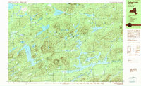 1989 Forked Lake1989 Print · USGSHamilton County in the late eighties remains a preserved wilderness of glacial ponds and mountain peaks within the Adirondack Park. Researchers can locate seasonal outposts like Deerland Camp and trace remote waterways from Lake Lila to the slopes of Antediluvian Mountain.2 unique versions available
End of results
Showing maps 1-2 of 2
Top cities near Woods
- Tupper Lake historical maps
- Webb historical maps
- Colton historical maps
- Indian Lake historical maps
- Ohio historical maps
- Lake Pleasant historical maps
See more
Frequently asked questions
- What are the different types of historical maps available for Woods?
- What is the oldest map of Woods?
- Where can I purchase historical maps of Woods for my home or office?
- Where can I download high-res historical maps of Woods?
- Are there historical topographic maps available for Woods?
- Is there historical aerial imagery available for Woods?
- Where are historical maps of Woods sourced from?