1940s Maps of Newport, New York
Explore 11 historic maps of Newport from the 1940s. These maps offer a rare glimpse into what life looked like during the 1940s — showing old roads, neighborhoods, homes, and landmarks that have changed or disappeared over time.
Whether you're researching your family's past, planning a metal detecting trip, or studying how Newport's landscape evolved across the 1940s, these high-resolution maps are a powerful tool for exploring the history of this region.
- Focus on a specific era: All maps on this page are from the 1940s, giving you a focused view of this time period.
- See what’s changed: Compare century-old streets, trails, and buildings to today's modern landscape using overlays and satellite layers.
- Research with precision: Use these maps for genealogy, historical research, land use analysis, or educational projects.
- View, download, or print: Maps are fully viewable online in high resolution, and can be downloaded or printed for your own records.
Start exploring Newport's history through authentic maps from the 1940s. This is your window into the past.
Newport, NY maps
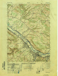
(11)- 1943 Map of Newport, 1953 Print
 1943 Newport1953 Print · USGSThe West Canada Valley comes alive in this wartime survey, showing the interconnected rail-and-river economies of Herkimer and Oneida Counties. Genealogists can trace the location of the Irish Settlement, family cemeteries like Bromley Cemetery, and several district schools.3 unique versions available
 - 1943 Map of Herkimer, 1960 Print
 1943 Herkimer1960 Print · USGSHerkimer and the Mohawk Valley are captured in the mid-1940s, showing the vital intersection of the Barge Canal and industrial rail lines. Genealogists can locate numerous country schoolhouses like Shells Bush Sch and family landmarks such as Dillenbeck Corners or Fort Herkimer.2 unique versions available
 - 1943 Map of Ilion, 1960 Print
 1943 Ilion1960 Print · USGSThe Mohawk Valley in the mid-1940s shows a landscape of river-and-rail industry centered on Frankfort and Ilion. Researchers can trace old rural schoolhouses like Little Red Sch and family-named intersections such as Johnson Corners and Minott Corners.
 - 1943 Map of Middleville, 1960 Print
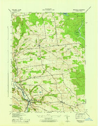
 1943 Middleville1960 Print · USGSHerkimer County's rural highlands and the West Canada Creek valley are captured here during the Second World War. Researchers can trace old schoolhouse sites like Dairy Hill Sch and find quiet burying grounds including Sweet Cem and Hardscrabble Cem.3 unique versions available
 - 1945 Map of Herkimer
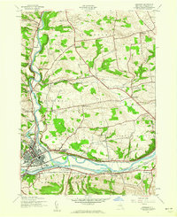
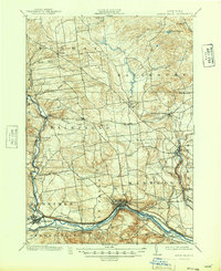
 1945 Herkimer1945 Print · USGSThe Mohawk River valley during the mid-forties was a hub of canal and rail activity connecting Herkimer and Little Falls. Genealogists and local historians can trace rural school districts like Shells Bush Sch and find the site of Fort Herkimer or the County Home.
 - 1945 Map of Newport
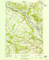
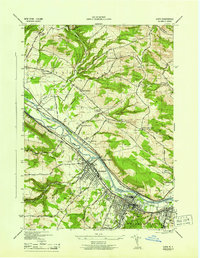
 1945 Newport1945 Print · USGSHerkimer County's West Canada Creek valley is shown at its mid-century peak of rural development, tracing the path of the New York Central railroad through Poland and Newport. Genealogists can locate family landmarks like the Irish Settlement, Bromley Cem, and many local schools.
 - 1945 Map of Ilion
 1945 Ilion1945 Print · USGSThe Mohawk Valley industrial corridor is captured here at its mid-century peak, showing the busy riverfronts of Ilion and Frankfort. Researchers can trace the dual paths of the Barge Canal and the abandoned Erie Canal alongside landmarks like the Little Red Schoolhouse.
 - 1946 Map of Middleville
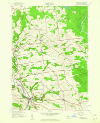
 1946 Middleville1946 Print · USGSHerkimer County's dairy country and river valleys are shown in detail during the mid-1940s, highlighting a landscape of upland farms and rural hamlets. Researchers can locate vanished landmarks like Dairy Hill Sch, the high Lookout Tower, and family burial grounds at Hardscrabble Cem.
 - 1949 Map of Ilion
 1949 Ilion1949 Print · USGSThe industrial Mohawk Valley corridor is frozen in time just after the war, showing the dense development of Ilion and Frankfort along the river. Genealogists can trace family roots through numerous rural landmarks like the Stone Schoolhouse, Budlong Cem, and East Schuyler Church.
 - 1949 Map of Herkimer
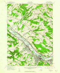
 1949 Herkimer1949 Print · USGSThe Mohawk Valley in the late 1940s is captured here, showing the critical intersection of the Barge Canal and the New York Central railroad. Genealogists and local historians can trace family roots through numerous district schools like Locust Grove Sch and Stone House School, or locate ancestral plots at Shells Bush Cem.
 - 1949 Map of Little Falls
 1949 Little Falls1949 Print · USGSHerkimer County's industrial heartland is captured here at mid-century, showcasing the vital Mohawk Valley transit corridor. Researchers can trace the path of the Erie Canal, the Barge Canal, and early rail stops like Ingham Mills Sta. and Dolgeville.
End of results
Showing maps 1-11 of 11
Top cities near Newport
- Utica historical maps
- New Hartford historical maps
- Whitestown historical maps
- German Flatts historical maps
- Herkimer historical maps
- Marcy historical maps
See more
Top neighborhoods of Newport
Frequently asked questions
- What are the different types of historical maps available for Newport?
- What is the oldest map of Newport?
- Where can I purchase historical maps of Newport for my home or office?
- Where can I download high-res historical maps of Newport?
- Are there historical topographic maps available for Newport?
- Is there historical aerial imagery available for Newport?
- Where are historical maps of Newport sourced from?