Old Maps of Herkimer County, New York
Explore 359 old maps of Herkimer County, spanning from 1897 to today. These high-resolution historic maps reveal how streets, neighborhoods, landmarks, and natural features evolved over time — perfect for genealogy, metal detecting, research, and local history exploration.
What you can do with these maps:
- See how Herkimer County changed over time: Compare historical maps to modern-day views to trace roads, homesites, rail lines & more.
- View detailed metadata: Each map includes creators, publishers, year, scale, and archive source.
- Overlay maps with satellite & LiDAR: Visualize the past alongside modern tools to explore terrain & human change.
- Trusted historical sources: Maps sourced from the USGS, Library of Congress, and other archives.
- Access maps your way: View online, download high-res files, or order prints for personal or research use.
Start exploring old maps of Herkimer County to uncover forgotten places, hidden landmarks, and the deep history beneath your feet.
Herkimer County, NY maps
(359)- 1897 Map of Remsen, 1958 Print
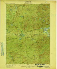
 1897 Remsen1958 Print · USGSOneida and Herkimer Counties are shown in the late 19th century as bustling timber and transit hubs before the modernization of the canal system. Local historians can trace the vital rail junctions at Remsen and the water-powered industrial sites like Bardwell Mill and Trenton Falls.
 - 1898 Map of Utica
 1898 Utica1898 Print · USGSThe Mohawk Valley was a powerhouse of industry and transport at the end of the Victorian era. Trace the path of the Erie Canal through Utica, or locate family homesteads near Barker Corners, Sheaf Corners, and Poland.
 - 1898 Map of Canajoharie, 1954 Print
 1898 Canajoharie1954 Print · USGSThe Mohawk Valley was at its industrial peak in the late 1890s, when the river, canal, and railroads all shared the same narrow corridor. Genealogists and historians can trace old homesteads and local landmarks in Stone Arabia, Ft. Plain, and the historic resort at Sharon Springs.
 - 1900 Map of Little Falls
 1900 Little Falls1900 Print · USGSThe Mohawk River valley serves as a bustling industrial artery at the turn of the century, dominated by canal and rail traffic. Genealogists can trace the early footprints of Little Falls, find the County House, or locate vanished stops like Ingham Mills Sta.
 - 1900 Map of Utica
 1900 Utica1900 Print · USGSThe Mohawk Valley was at its industrial peak at the turn of the century, anchored by the rail and canal nexus of Utica. Genealogists can trace family names through rural crossroads like Martin Corners and Brayton Corners, or follow the industrial sprawl of the Erie Canal into Ilion.9 unique versions available
 - 1900 Map of Canajoharie
 1900 Canajoharie1900 Print · USGSThe Mohawk Valley at the turn of the century shows a dense network of canal, rail, and river transportation. Genealogists can trace family footprints in historic Canajoharie, the upland farms near Stone Arabia, and the resort area of Sharon Springs.
 - 1900 Map of Remsen
 1900 Remsen1900 Print · USGSOneida and Herkimer Counties at the turn of the century show a landscape shaped by the rail-and-canal economy. Genealogists can trace family roots through settlements like Remsen, Hinckley, and Trenton Falls or locate industrial sites such as Bardwell Mill.9 unique versions available
 - 1900 Map of Wilmurt
 1900 Wilmurt1900 Print · USGSThe Adirondack foothills of Herkimer and Hamilton counties appear here at the turn of the century, showing a landscape of isolated hamlets and timber-rich woods. Genealogists can trace family roots in Wilmurt, Nobleboro, and Morehouseville or locate landmarks like Twin Lakes Reservoir and Hinckley Lake.
 - 1901 Map of Old Forge
 1901 Old Forge1901 Print · USGSIn the Adirondack wilderness at the turn of the century, this area shows a unique network of early camps and water routes. Researchers can trace the Steamboat Route through the Chain Lakes or locate historic outposts like Bishy Lodge and Atwell.10 unique versions available
 - 1901 Map of Lassellsville, 1959 Print
 1901 Lassellsville1959 Print · USGSFulton and Montgomery Counties come alive in this turn-of-the-century survey of the Mohawk Valley and southern Adirondacks. Genealogists and researchers can pinpoint family holdings near Irish Settlement, the industry of Newkirk Mills, and the rails of the N. Y. C. and H. R. R. R.
 - 1902 Map of Canajoharie
 1902 Canajoharie1902 Print · USGSThe Mohawk Valley was a bustling corridor of canal traffic and steam power just after the turn of the century. Genealogists can trace family names and farmsteads near Stone Arabia or explore the resort layout of Sharon Springs and the industrial hubs of Ft. Plain and Canajoharie.6 unique versions available
 - 1902 Map of Wilmurt
 1902 Wilmurt1902 Print · USGSThe Adirondack foothills are captured here in the late nineteenth century, showing a landscape defined by logging-era headwaters and remote hamlets. Genealogists and researchers can trace early roads and river landings through Wilmurt, Nobleboro, and Morehouseville.8 unique versions available
 - 1903 Map of Big Moose
 1903 Big Moose1903 Print · USGSThe Adirondack wilderness of the early twentieth century was a landscape of remote rail outposts and hidden glacial lakes. Trace the Adirondack Division line through the mountains to find family camps near Big Moose, Eagle Bay, and the Steamboat Route.11 unique versions available
 - 1903 Map of Richfield Springs
 1903 Richfield Springs1903 Print · USGSThe northern Otsego County landscape at the turn of the century shows a bustling rural economy centered around the headwaters of the Susquehanna. Researchers can trace the early Steamboat Route on Otsego Lake and explore rail-era depots like Richfield Springs and Cherry Valley.6 unique versions available
 - 1903 Map of Lassellsville
 1903 Lassellsville1903 Print · USGSFulton County at the start of the century shows a landscape of upland mill sites and busy valley railroads. Genealogists can trace family names at Irish Settlement, Fical Corners, and the mill sites at Newkirk Mills.6 unique versions available
 - 1903 Map of Little Falls
 1903 Little Falls1903 Print · USGSThe Mohawk Valley was a bustling corridor of industry and transit at the turn of the century, where the river met a network of canals and railroads. Genealogists and historians can trace the foundations of Little Falls, find the historic site of Fort Herkimer, and locate rural landmarks like the County House.6 unique versions available
 - 1904 Map of Piseco Lake
 1904 Piseco Lake1904 Print · USGSThe central Adirondacks in the early 1900s centered on the waters of Piseco Lake and the winding West Canada Creek. Local historians can trace early outposts and settlements like Hoffmeister, Rudeston, and the isolated Mountain House.
 - 1906 Map of Piseco Lake
 1906 Piseco Lake1906 Print · USGSThe Adirondack wilderness of the early twentieth century comes into focus through this survey of the high-country lake district. Researchers can find logging-era outposts and early resorts like Mountain House, Rudeston, and the remote Powley Place.7 unique versions available
 - 1907 Map of Winfield
 1907 Winfield1907 Print · USGSCentral New York's dairy and rail corridor is captured here at the start of the century. Genealogists can trace family names across hamlets like Millers Mills and Plainfield Center, or locate old depots along the Unadilla Valley RR.6 unique versions available
 - 1908 Map of Piseco Lake, 1918 Print
 1908 Piseco Lake1918 Print · USGSThe southern Adirondacks at the turn of the century appear as a network of isolated homesteads and family camps. Trace early settlements like Piseco and Hoffmeister or find remote landmarks such as Mountain House, Powley Place, and Clockmill Corners.
 - 1912 Map of Number Four
 1912 Number Four1912 Print · USGSThe Adirondack wilderness of Herkimer and Lewis counties is captured here in the early twentieth century before modern development. Trace the remote waterways from the Oswegatchie River down to Soft Maple Dam or locate family landmarks near Balsam Flats and Stillwater Mtn.
 - 1912 Map of Mc Keever
 1912 Mc Keever1912 Print · USGSThe southwestern Adirondack wilderness comes into focus in this early twentieth-century survey, showcasing the arrival of the railroad in a landscape of logging camps. Genealogists and researchers can trace the development of Mc Keever and locate family-named sites like Millard's Camp, Porters Corners, and Becks Camp.8 unique versions available
 - 1915 Map of Number Four
 1915 Number Four1915 Print · USGSThe wilderness of the North Country comes into focus in this pre-war survey of the Lewis and Herkimer county line. Researchers can trace the remote settlement of Number Four and locate early landmarks like Silver Mine Dam and Stillwater Mtn.5 unique versions available
 - 1916 Map of Oswegatchie
 1916 Oswegatchie1916 Print · USGSSt. Lawrence County industry and wilderness meet in the early twentieth century along the Oswegatchie River. Genealogists and historians can trace rail-tied settlements at Benson Mines, remote schools like White School, and numerous named lumber and sporting camps.3 unique versions available
 - 1918 Map of Oswegatchie
 1918 Oswegatchie1918 Print · USGSThe Adirondack wilderness in the 1910s reveals a hardworking landscape of iron mines and timber camps. Genealogists and historians can trace family roots at Benson Mines, locate remote schoolhouses like White School, and follow the path of the Lumber R. R.5 unique versions available
Showing maps 1-25 of 359
Top cities of Herkimer County
- German Flatts historical maps
- Herkimer historical maps
- Frankfort historical maps
- Little Falls historical maps
- Schuyler historical maps
- Manheim historical maps
See more
Frequently asked questions
- What are the different types of historical maps available for Herkimer County?
- What is the oldest map of Herkimer County?
- Where can I purchase historical maps of Herkimer County for my home or office?
- Where can I download high-res historical maps of Herkimer County?
- Are there historical topographic maps available for Herkimer County?
- Is there historical aerial imagery available for Herkimer County?
- Where are historical maps of Herkimer County sourced from?