Old Maps of Herkimer County, New York for Metal Detecting
Plan your next treasure hunt with 175 historic maps of Herkimer County. Find old homesites, ghost towns, trails, and gathering spots that may be lost to time — perfect for identifying promising metal detecting locations.
- Locate forgotten sites: Uncover places like long-lost settlements, abandoned rail lines, or gathering spots.
- Plan better hunts: Use map overlays combined with LiDAR or satellite views to narrow in on historically rich areas.
- Made for detectorists: Thousands of hobbyists use these maps to discover relics, coins, and hidden history.
Use these historic maps to boost your research and find new opportunities beneath the surface of Herkimer County.
Herkimer County, NY maps
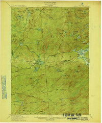
(175)- 1897 Map of Remsen, 1958 Print
 1897 Remsen1958 Print · USGSCovers Herkimer County, including Boonville, Trenton, and other nearby areas
 - 1898 Map of Utica
 1898 Utica1898 Print · USGSCovers Herkimer County, including Utica, New Hartford, and other nearby areas
 - 1898 Map of Canajoharie, 1954 Print
 1898 Canajoharie1954 Print · USGSCovers Herkimer County, including Minden, Canajoharie, and other nearby areas
 - 1900 Map of Little Falls
 1900 Little Falls1900 Print · USGSCovers Herkimer County, including German Flatts, Herkimer, and other nearby areas
 - 1900 Map of Utica
 1900 Utica1900 Print · USGSCovers Herkimer County, including Utica, New Hartford, and other nearby areas9 unique versions available
 - 1900 Map of Canajoharie
 1900 Canajoharie1900 Print · USGSCovers Herkimer County, including Minden, Canajoharie, and other nearby areas
 - 1900 Map of Remsen
 1900 Remsen1900 Print · USGSCovers Herkimer County, including Boonville, Trenton, and other nearby areas9 unique versions available
 - 1900 Map of Wilmurt
 1900 Wilmurt1900 Print · USGSCovers Herkimer County, including Salisbury, Ohio, and other nearby areas
 - 1901 Map of Old Forge
 1901 Old Forge1901 Print · USGSCovers Herkimer County, including Webb, Ohio, and other nearby areas10 unique versions available
 - 1901 Map of Lassellsville, 1959 Print
 1901 Lassellsville1959 Print · USGSCovers Herkimer County, including Johnstown, Palatine, and other nearby areas
 - 1902 Map of Canajoharie
 1902 Canajoharie1902 Print · USGSCovers Herkimer County, including Minden, Canajoharie, and other nearby areas6 unique versions available
 - 1902 Map of Wilmurt
 1902 Wilmurt1902 Print · USGSCovers Herkimer County, including Salisbury, Ohio, and other nearby areas8 unique versions available
 - 1903 Map of Big Moose
 1903 Big Moose1903 Print · USGSCovers Herkimer County, including Webb, Long Lake, and other nearby areas11 unique versions available
 - 1903 Map of Richfield Springs
 1903 Richfield Springs1903 Print · USGSCovers Herkimer County, including German Flatts, Minden, and other nearby areas6 unique versions available
 - 1903 Map of Lassellsville
 1903 Lassellsville1903 Print · USGSCovers Herkimer County, including Johnstown, Palatine, and other nearby areas6 unique versions available
 - 1903 Map of Little Falls
 1903 Little Falls1903 Print · USGSCovers Herkimer County, including German Flatts, Herkimer, and other nearby areas6 unique versions available
 - 1904 Map of Piseco Lake
 1904 Piseco Lake1904 Print · USGSCovers Herkimer County, including Salisbury, Stratford, and other nearby areas
 - 1906 Map of Piseco Lake
 1906 Piseco Lake1906 Print · USGSCovers Herkimer County, including Salisbury, Stratford, and other nearby areas7 unique versions available
 - 1907 Map of Winfield
 1907 Winfield1907 Print · USGSCovers Herkimer County, including German Flatts, Ilion, and other nearby areas6 unique versions available
 - 1908 Map of Piseco Lake, 1918 Print
 1908 Piseco Lake1918 Print · USGSCovers Herkimer County, including Salisbury, Stratford, and other nearby areas
 - 1912 Map of Number Four
 1912 Number Four1912 Print · USGSCovers Herkimer County, including Croghan, New Bremen, and other nearby areas
 - 1912 Map of Mc Keever
 1912 Mc Keever1912 Print · USGSCovers Herkimer County, including Boonville, Webb, and other nearby areas8 unique versions available
 - 1915 Map of Number Four
 1915 Number Four1915 Print · USGSCovers Herkimer County, including Croghan, New Bremen, and other nearby areas5 unique versions available
 - 1916 Map of Oswegatchie
 1916 Oswegatchie1916 Print · USGSCovers Herkimer County, including Oswegatchie, Croghan, and other nearby areas3 unique versions available
 - 1918 Map of Oswegatchie
 1918 Oswegatchie1918 Print · USGSCovers Herkimer County, including Oswegatchie, Croghan, and other nearby areas5 unique versions available
Showing maps 1-25 of 175
Top cities of Herkimer County
- German Flatts historical maps
- Herkimer historical maps
- Frankfort historical maps
- Little Falls historical maps
- Schuyler historical maps
- Manheim historical maps
See more
Frequently asked questions
- What are the different types of historical maps available for Herkimer County?
- What is the oldest map of Herkimer County?
- Where can I purchase historical maps of Herkimer County for my home or office?
- Where can I download high-res historical maps of Herkimer County?
- Are there historical topographic maps available for Herkimer County?
- Is there historical aerial imagery available for Herkimer County?
- Where are historical maps of Herkimer County sourced from?