Old Maps of Herkimer County, New York for Hiking & Exploration
Hike through history with 175 historic maps of Herkimer County. Explore old trails, ghost towns, and forgotten backroads — perfect for outdoor adventurers and local explorers.
- Rediscover forgotten places: Map out old mining camps, roads, and footpaths that no longer exist on modern maps.
- Layer with modern tools: Combine with LiDAR or satellite views to plan hikes through historical terrain.
- Made for exploration: Popular among hikers, overlanders, and local history lovers.
Use these maps to find adventure and explore the hidden past of Herkimer County.
Herkimer County, NY maps
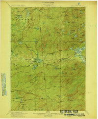
(175)- 1897 Map of Remsen, 1958 Print
 1897 Remsen1958 Print · USGSCovers Herkimer County, including Boonville, Trenton, and other nearby areas
 - 1898 Map of Utica
 1898 Utica1898 Print · USGSCovers Herkimer County, including Utica, New Hartford, and other nearby areas
 - 1898 Map of Canajoharie, 1954 Print
 1898 Canajoharie1954 Print · USGSCovers Herkimer County, including Minden, Canajoharie, and other nearby areas
 - 1900 Map of Little Falls
 1900 Little Falls1900 Print · USGSCovers Herkimer County, including German Flatts, Herkimer, and other nearby areas
 - 1900 Map of Utica
 1900 Utica1900 Print · USGSCovers Herkimer County, including Utica, New Hartford, and other nearby areas9 unique versions available
 - 1900 Map of Canajoharie
 1900 Canajoharie1900 Print · USGSCovers Herkimer County, including Minden, Canajoharie, and other nearby areas
 - 1900 Map of Remsen
 1900 Remsen1900 Print · USGSCovers Herkimer County, including Boonville, Trenton, and other nearby areas9 unique versions available
 - 1900 Map of Wilmurt
 1900 Wilmurt1900 Print · USGSCovers Herkimer County, including Salisbury, Ohio, and other nearby areas
 - 1901 Map of Old Forge
 1901 Old Forge1901 Print · USGSCovers Herkimer County, including Webb, Ohio, and other nearby areas10 unique versions available
 - 1901 Map of Lassellsville, 1959 Print
 1901 Lassellsville1959 Print · USGSCovers Herkimer County, including Johnstown, Palatine, and other nearby areas
 - 1902 Map of Canajoharie
 1902 Canajoharie1902 Print · USGSCovers Herkimer County, including Minden, Canajoharie, and other nearby areas6 unique versions available
 - 1902 Map of Wilmurt
 1902 Wilmurt1902 Print · USGSCovers Herkimer County, including Salisbury, Ohio, and other nearby areas8 unique versions available
 - 1903 Map of Big Moose
 1903 Big Moose1903 Print · USGSCovers Herkimer County, including Webb, Long Lake, and other nearby areas11 unique versions available
 - 1903 Map of Richfield Springs
 1903 Richfield Springs1903 Print · USGSCovers Herkimer County, including German Flatts, Minden, and other nearby areas6 unique versions available
 - 1903 Map of Lassellsville
 1903 Lassellsville1903 Print · USGSCovers Herkimer County, including Johnstown, Palatine, and other nearby areas6 unique versions available
 - 1903 Map of Little Falls
 1903 Little Falls1903 Print · USGSCovers Herkimer County, including German Flatts, Herkimer, and other nearby areas6 unique versions available
 - 1904 Map of Piseco Lake
 1904 Piseco Lake1904 Print · USGSCovers Herkimer County, including Salisbury, Stratford, and other nearby areas
 - 1906 Map of Piseco Lake
 1906 Piseco Lake1906 Print · USGSCovers Herkimer County, including Salisbury, Stratford, and other nearby areas7 unique versions available
 - 1907 Map of Winfield
 1907 Winfield1907 Print · USGSCovers Herkimer County, including German Flatts, Ilion, and other nearby areas6 unique versions available
 - 1908 Map of Piseco Lake, 1918 Print
 1908 Piseco Lake1918 Print · USGSCovers Herkimer County, including Salisbury, Stratford, and other nearby areas
 - 1912 Map of Number Four
 1912 Number Four1912 Print · USGSCovers Herkimer County, including Croghan, New Bremen, and other nearby areas
 - 1912 Map of Mc Keever
 1912 Mc Keever1912 Print · USGSCovers Herkimer County, including Boonville, Webb, and other nearby areas8 unique versions available
 - 1915 Map of Number Four
 1915 Number Four1915 Print · USGSCovers Herkimer County, including Croghan, New Bremen, and other nearby areas5 unique versions available
 - 1916 Map of Oswegatchie
 1916 Oswegatchie1916 Print · USGSCovers Herkimer County, including Oswegatchie, Croghan, and other nearby areas3 unique versions available
 - 1918 Map of Oswegatchie
 1918 Oswegatchie1918 Print · USGSCovers Herkimer County, including Oswegatchie, Croghan, and other nearby areas5 unique versions available
Showing maps 1-25 of 175
Top cities of Herkimer County
- German Flatts historical maps
- Herkimer historical maps
- Frankfort historical maps
- Little Falls historical maps
- Schuyler historical maps
- Manheim historical maps
See more
Frequently asked questions
- What are the different types of historical maps available for Herkimer County?
- What is the oldest map of Herkimer County?
- Where can I purchase historical maps of Herkimer County for my home or office?
- Where can I download high-res historical maps of Herkimer County?
- Are there historical topographic maps available for Herkimer County?
- Is there historical aerial imagery available for Herkimer County?
- Where are historical maps of Herkimer County sourced from?