1950s Maps of Ellisburg, New York
Explore 5 historic maps of Ellisburg from the 1950s. These maps offer a rare glimpse into what life looked like during the 1950s — showing old roads, neighborhoods, homes, and landmarks that have changed or disappeared over time.
Whether you're researching your family's past, planning a metal detecting trip, or studying how Ellisburg's landscape evolved across the 1950s, these high-resolution maps are a powerful tool for exploring the history of this region.
- Focus on a specific era: All maps on this page are from the 1950s, giving you a focused view of this time period.
- See what’s changed: Compare century-old streets, trails, and buildings to today's modern landscape using overlays and satellite layers.
- Research with precision: Use these maps for genealogy, historical research, land use analysis, or educational projects.
- View, download, or print: Maps are fully viewable online in high resolution, and can be downloaded or printed for your own records.
Start exploring Ellisburg's history through authentic maps from the 1950s. This is your window into the past.
Ellisburg, NY maps
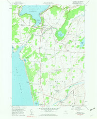
(5)- 1958 Map of Ellisburg, 1960 Print
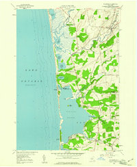 1958 Ellisburg1960 Print · USGSCoastal Jefferson County in the late fifties is captured here as a landscape of barrier ponds and rural crossroad hamlets. Researchers can trace the family names and early lakefront infrastructure around Ellisburg, Sandy Pond Corners, and the shores of North Pond.2 unique versions available
 - 1958 Map of Sandy Creek, 1960 Print
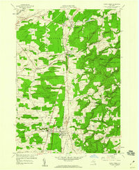 1958 Sandy Creek1960 Print · USGSNorthern New York's agricultural and rail-dependent landscape comes alive in the late fifties as the New York Central Railroad links rural hubs. Researchers can trace ancestral locations from Pierrepont Manor to the Wesleyan Cem or locate the old Fairground near Sandy Creek.4 unique versions available
 - 1958 Map of Stony Point, 1960 Print
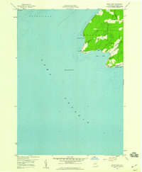 1958 Stony Point1960 Print · USGSThe Jefferson County shoreline comes into focus in the late 1950s, highlighting the strategic maritime position of this peninsula. Researchers can trace the rural landscape around the Lighthouse and explore the distinct coastal inlets of Gravely Bay and Ray Bay.2 unique versions available
 - 1959 Map of Adams, 1961 Print
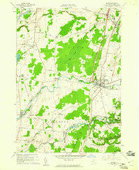 1959 Adams1961 Print · USGSJefferson County was transitioning into the modern highway era in the late fifties as the EMPIRE STATEWAY began to cut through traditional farm country. Genealogists can trace family roots through numerous locations like Wardwell Settlement, St Cecelias Ch, and Giddingsville Cem.3 unique versions available
 - 1959 Map of Henderson, 1961 Print
 1959 Henderson1961 Print · USGSJefferson County’s lakefront and agricultural interior are captured here in the late fifties, showing the region before modern development. Genealogists can trace family footprints at Carpenter Cem or Rural Hill, while exploring maritime sites like Henderson Harbor and Whites Bay.3 unique versions available
End of results
Showing maps 1-5 of 5
Top cities near Ellisburg
- Watertown historical maps
- Scriba historical maps
- Watertown historical maps
- Brownville historical maps
- Richland historical maps
- Adams historical maps
See more
Top neighborhoods of Ellisburg
- Saxe Corner historical maps
- Taylor Settlement historical maps
- Cobbtown historical maps
- Montario Point historical maps
- Wardwell historical maps
- Giddingsville historical maps
See more
Frequently asked questions
- What are the different types of historical maps available for Ellisburg?
- What is the oldest map of Ellisburg?
- Where can I purchase historical maps of Ellisburg for my home or office?
- Where can I download high-res historical maps of Ellisburg?
- Are there historical topographic maps available for Ellisburg?
- Is there historical aerial imagery available for Ellisburg?
- Where are historical maps of Ellisburg sourced from?