1940s Maps of Henderson, New York
Explore 6 historic maps of Henderson from the 1940s. These maps offer a rare glimpse into what life looked like during the 1940s — showing old roads, neighborhoods, homes, and landmarks that have changed or disappeared over time.
Whether you're researching your family's past, planning a metal detecting trip, or studying how Henderson's landscape evolved across the 1940s, these high-resolution maps are a powerful tool for exploring the history of this region.
- Focus on a specific era: All maps on this page are from the 1940s, giving you a focused view of this time period.
- See what’s changed: Compare century-old streets, trails, and buildings to today's modern landscape using overlays and satellite layers.
- Research with precision: Use these maps for genealogy, historical research, land use analysis, or educational projects.
- View, download, or print: Maps are fully viewable online in high resolution, and can be downloaded or printed for your own records.
Start exploring Henderson's history through authentic maps from the 1940s. This is your window into the past.
Henderson, NY maps
(6)- 1942 Map of Stony Point
 1942 Stony Point1942 Print · USGSThe Jefferson County shoreline of Lake Ontario is captured here during the early years of World War II. Researchers can locate the Stony Point Light House and the extensive Stony Point Rifle Range along the coast of Henderson.
 - 1942 Map of Henderson Bay
 1942 Henderson Bay1942 Print · USGSJefferson County’s shoreline comes alive in the early 1940s, highlighting the military presence at the historic Madison Barracks. Researchers can trace old lakeside schoolhouses and family cemeteries like Stone Cem or explore the waterfront detail near Sackets Harbor.
 - 1942 Map of Point Peninsula
 1942 Point Peninsula1942 Print · USGSJefferson County shorelines were a landscape of military readiness and isolated lake outposts during the Second World War. Researchers can trace the boundaries of the U S Military Res, find family landmarks like Cooper, and locate the Stony Point Rifle Range.
 - 1943 Map of Henderson
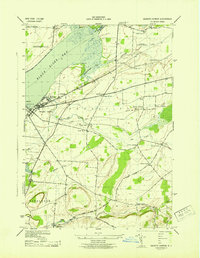
 1943 Henderson1943 Print · USGSJefferson County’s eastern Lake Ontario shoreline is shown here during the war years, capturing the rural community before modern coastal development. Genealogists can trace family names across a landscape dotted with sites like Carpenter Cem, Bishop Street, and Henderson Harbor.
 - 1943 Map of Sackets Harbor
 1943 Sackets Harbor1943 Print · USGSSackets Harbor and its military waterfront are captured in the early 1940s during a period of active defense and local growth. Genealogists can trace family names through rural junctions like Baggs Corners and identify several rural schoolhouses or the Muskalonge Cem.
 - 1943 Map of Adams
 1943 Adams1943 Print · USGSJefferson County's rural heartland is documented here during the early 1940s, showing a landscape defined by small settlements and the Central New York rail line. Researchers can trace ancestral locations at Taylor Settlement, School No 5, and Elmwood Cem.
End of results
Showing maps 1-6 of 6
Top cities near Henderson
- Brownville historical maps
- Adams historical maps
- Sandy Creek historical maps
- Ellisburg historical maps
- Hounsfield historical maps
- Cape Vincent historical maps
See more
Top neighborhoods of Henderson
- Butterville historical maps
- Roberts Corner historical maps
- Henderson Harbor historical maps
- Hungerford Corners historical maps
- Clark Point historical maps
- Babbitt Corner historical maps
See more
Frequently asked questions
- What are the different types of historical maps available for Henderson?
- What is the oldest map of Henderson?
- Where can I purchase historical maps of Henderson for my home or office?
- Where can I download high-res historical maps of Henderson?
- Are there historical topographic maps available for Henderson?
- Is there historical aerial imagery available for Henderson?
- Where are historical maps of Henderson sourced from?