1940s Maps of Hounsfield, New York
Explore 10 historic maps of Hounsfield from the 1940s. These maps offer a rare glimpse into what life looked like during the 1940s — showing old roads, neighborhoods, homes, and landmarks that have changed or disappeared over time.
Whether you're researching your family's past, planning a metal detecting trip, or studying how Hounsfield's landscape evolved across the 1940s, these high-resolution maps are a powerful tool for exploring the history of this region.
- Focus on a specific era: All maps on this page are from the 1940s, giving you a focused view of this time period.
- See what’s changed: Compare century-old streets, trails, and buildings to today's modern landscape using overlays and satellite layers.
- Research with precision: Use these maps for genealogy, historical research, land use analysis, or educational projects.
- View, download, or print: Maps are fully viewable online in high resolution, and can be downloaded or printed for your own records.
Start exploring Hounsfield's history through authentic maps from the 1940s. This is your window into the past.
Hounsfield, NY maps
(10)- 1942 Map of Stony Point
 1942 Stony Point1942 Print · USGSThe Jefferson County shoreline of Lake Ontario is captured here during the early years of World War II. Researchers can locate the Stony Point Light House and the extensive Stony Point Rifle Range along the coast of Henderson.
 - 1942 Map of Henderson Bay
 1942 Henderson Bay1942 Print · USGSJefferson County’s shoreline comes alive in the early 1940s, highlighting the military presence at the historic Madison Barracks. Researchers can trace old lakeside schoolhouses and family cemeteries like Stone Cem or explore the waterfront detail near Sackets Harbor.
 - 1942 Map of Galloo Island
 1942 Galloo Island1942 Print · USGSIsolated in eastern Lake Ontario during the early 1940s, this island survey reveals a landscape dedicated to maritime safety and navigation. Researchers can trace the layout of the Galloo Island L H, the Coast Guard Sta, and activity at Gill Harbor.
 - 1942 Map of Point Peninsula
 1942 Point Peninsula1942 Print · USGSJefferson County shorelines were a landscape of military readiness and isolated lake outposts during the Second World War. Researchers can trace the boundaries of the U S Military Res, find family landmarks like Cooper, and locate the Stony Point Rifle Range.
 - 1943 Map of Sackets Harbor
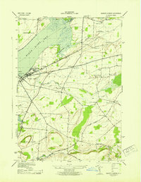 1943 Sackets Harbor1943 Print · USGSSackets Harbor and its military waterfront are captured in the early 1940s during a period of active defense and local growth. Genealogists can trace family names through rural junctions like Baggs Corners and identify several rural schoolhouses or the Muskalonge Cem.
 - 1943 Map of Dexter
 1943 Dexter1943 Print · USGSJefferson County life in the early 1940s is centered on the riverfront industry and rail connections of the lake plain. Genealogists can locate family burial grounds like Freeman Cem and identify numerous rural schoolhouses including School No 16 and School No 8.
 - 1943 Map of Watertown
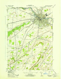 1943 Watertown1943 Print · USGSJefferson County during the early 1940s reveals a landscape defined by the manufacturing hubs of Watertown and the rural schools of the surrounding townships. Researchers can trace local lineages through detailed labels for Fields Settlement Cem, Talcott Corners, and the County Boys School.
 - 1943 Map of Brownville
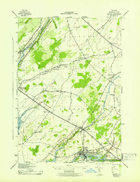
 1943 Brownville1943 Print · USGSJefferson County during the mid-forties remains a landscape of traditional rural districts and small hamlets connected by the New York Central line. Researchers can trace the layout of early school districts and secluded burial sites like Taylor Cem or Sandy Loam Cem.
 - 1948 Map of Theresa, 1953 Print
 1948 Theresa1953 Print · USGSJefferson County's rural landscape is captured here in the late 1940s as military expansion and river-based industry shaped the region. Researchers can trace family roots through numerous sites like St Marys Cemetery, Bacon School, and the Pine Camp Military Reservation.
 - 1948 Map of Ogdensburg, 1973 Print
 1948 Ogdensburg1973 Print · USGSThe international border along the St Lawrence River comes to life in the late 1940s, showing the vital rail and water connections between New York and Ontario. Researchers can trace the grounds of St Lawrence University, the massive Camp Drum military reservation, and the historic Rideau River and Canal.2 unique versions available
End of results
Showing maps 1-10 of 10
Top cities near Hounsfield
- Brownville historical maps
- Adams historical maps
- Clayton historical maps
- Ellisburg historical maps
- Orleans historical maps
- Cape Vincent historical maps
See more
Top neighborhoods of Hounsfield
- East Hounsfield historical maps
- Alverson historical maps
- Baggs Corner historical maps
- Camps Mills historical maps
- Jewettville historical maps
- Sulphur Springs historical maps
See more
Frequently asked questions
- What are the different types of historical maps available for Hounsfield?
- What is the oldest map of Hounsfield?
- Where can I purchase historical maps of Hounsfield for my home or office?
- Where can I download high-res historical maps of Hounsfield?
- Are there historical topographic maps available for Hounsfield?
- Is there historical aerial imagery available for Hounsfield?
- Where are historical maps of Hounsfield sourced from?