1950s Maps of Wilna, New York
Explore 9 historic maps of Wilna from the 1950s. These maps offer a rare glimpse into what life looked like during the 1950s — showing old roads, neighborhoods, homes, and landmarks that have changed or disappeared over time.
Whether you're researching your family's past, planning a metal detecting trip, or studying how Wilna's landscape evolved across the 1950s, these high-resolution maps are a powerful tool for exploring the history of this region.
- Focus on a specific era: All maps on this page are from the 1950s, giving you a focused view of this time period.
- See what’s changed: Compare century-old streets, trails, and buildings to today's modern landscape using overlays and satellite layers.
- Research with precision: Use these maps for genealogy, historical research, land use analysis, or educational projects.
- View, download, or print: Maps are fully viewable online in high resolution, and can be downloaded or printed for your own records.
Start exploring Wilna's history through authentic maps from the 1950s. This is your window into the past.
Wilna, NY maps
(9)- 1950 Map of Deferiet
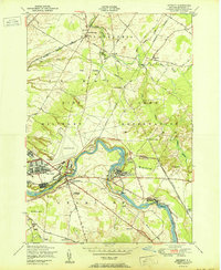 1950 Deferiet1950 Print · USGSJefferson County at the mid-century is defined here by the confluence of industrial river towns and the growing Pine Camp Military Reservation. Trace family roots and local history through School No 14, Sterlingville, and the F. W. Woolworth Memorial Cemetery.
 - 1950 Map of Utica, 1951 Print
 1950 Utica1951 Print · USGSCentral New York in the post-war era showcases the industrial Mohawk Valley and the pristine Adirondack interior. Researchers can trace transportation networks like the New York Central Railroad and find early Cold War sites such as Griffiss Air Force Base.
 - 1951 Map of Philadelphia
 1951 Philadelphia1951 Print · USGSJefferson County’s rural and military landscape comes into focus during the early fifties, centered on the river-and-rail hub of Philadelphia. Researchers can trace old family settlements at Bishops Corners and locate rural landmarks such as the Quaker Cemetery and School No 4.
 - 1951 Map of Antwerp
 1951 Antwerp1951 Print · USGSAntwerp and its surroundings in the early fifties were shaped by the intersection of the New York Central Railroad and the expansive Pine Camp Military Reservation. Researchers can trace old district boundaries and local landmarks like Hillside Cem, School No 15, and the course of the Indian River.
 - 1951 Map of North Wilna
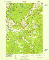
 1951 North Wilna1951 Print · USGSThe Jefferson and Lewis County line area is shown here in the early fifties, featuring the large Pine Camp Military Reservation and its surrounding rural hamlets. Local researchers can trace family-named sites like Ormiston Corners, old district schoolhouses, and the Natural Bridge Cemetery near the Indian River.
 - 1951 Map of Ogdensburg
 1951 Ogdensburg1951 Print · USGSThe St. Lawrence frontier and the North Country are captured here during the post-war era, from the river ports to the high Adirondacks. Genealogists and historians can trace the rail-and-river economy through Ogdensburg, the Rutland rail lines, and Potsdam.
 - 1951 Map of Natural Bridge, 1953 Print
 1951 Natural Bridge1953 Print · USGSThe Jefferson and Lewis county line comes alive in the early fifties, showing a landscape shaped by the New York Central railroad and military expansion. Genealogists can locate family landmarks like Hillside Cem, Blanchard Corners, and the settlement at Natural Bridge.4 unique versions available
 - 1953 Map of Ogdensburg
 1953 Ogdensburg1953 Print · USGSThe North Country and St. Lawrence Valley are shown here in the early fifties, just as the region’s rail-and-river economy remained in full swing. Genealogists and historians can trace family-named corners and rural hubs along the Rutland railroad or locate heritage sites near Ogdensburg, Potsdam, and the St Regis Indian Reservation.
 - 1957 Map of Utica
 1957 Utica1957 Print · USGSCentral New York and the Adirondack foothills are captured here in the mid-fifties, showing a landscape defined by the Mohawk River corridor and the growing highway system. Genealogists and researchers can trace the rail lines of the New York Central and locate communities from Lowville to Gloversville.
End of results
Showing maps 1-9 of 9
Top cities near Wilna
- Le Ray historical maps
- Gouverneur historical maps
- Lowville historical maps
- Champion historical maps
- Alexandria historical maps
- Carthage historical maps
See more
Top neighborhoods of Wilna
- North Croghan historical maps
- North Wilna historical maps
- Karter historical maps
- Reedville historical maps
- Fargo historical maps
- Cowan Corner historical maps
See more
Frequently asked questions
- What are the different types of historical maps available for Wilna?
- What is the oldest map of Wilna?
- Where can I purchase historical maps of Wilna for my home or office?
- Where can I download high-res historical maps of Wilna?
- Are there historical topographic maps available for Wilna?
- Is there historical aerial imagery available for Wilna?
- Where are historical maps of Wilna sourced from?