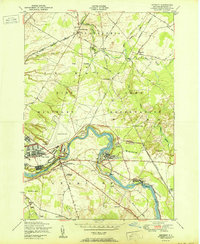
1950 Map of Deferiet
USGS Topo · Published 1950About this map
The Black River defines the industrial and military heart of this landscape, carving a deep arc through the Pine Camp Military Reservation at the mid-century. This survey captures a dense network of river-oriented settlements including Deferiet, Great Bend, and Herring, where the presence of Gatehouses and proximity to the New York Central railroad signal the era's manufacturing and logistical importance. The northern expanse is dominated by the Pine Plains and the rural crossroads of Sterlingville and Strickland Corners, providing a sharp contrast to the specialized military infrastructure of Pine Camp and the aviation facilities at Wheeler Sack Field. Genealogists may find value in the specific locations of several rural schoolhouses and the F. W. Woolworth Memorial Cemetery, which sit alongside established transit routes like Bedlam Road and Reedville Road.
Find a feature on this map
45 named features on this map. Tap any name to fly to it.
Don’t see what you’re looking for? This feature index may not catch every label — zoom into the map to look around manually.
Map Details
Editions of this 1950 Deferiet Map
This is the sole edition of this map. No revisions or reprints were ever made.
Other maps of this area

1895 · Watertown
USGS Topo · 1:62,500

1898 · Watertown
USGS Topo · 1:62,500

1902 · Carthage
USGS Topo · 1:62,500

1903 · Theresa
USGS Topo · 1:62,500

1904 · Carthage
USGS Topo · 1:62,500

1908 · Watertown
USGS Topo · 1:62,500

1909 · Watertown
USGS Topo · 1:62,500

1911 · Antwerp
USGS Topo · 1:62,500

1942 · Copenhagen
USGS Topo · 1:24,000

1943 · Copenhagen
USGS Topo · 1:31,680