
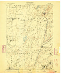
1902 Map of Carthage
USGS Topo · Published 1902About this map
The Black River corridor serves as the industrial and transit spine of this 1902 survey, anchoring the manufacturing centers of Carthage and West Carthage at the northern edge. The landscape is defined by its transition from the river valley to the rising plateaus of the Tug Hill region, marked by the dramatic drop of High Falls near Copenhagen. This era shows a complex network of railroads including the N. Y. C. and H. R. R. R. Adirondack Br. and the R. W. and O. Div., which facilitated the movement of timber and agricultural products from Lewis and Jefferson counties.
Find a feature on this map
51 named features on this map. Tap any name to fly to it.
Don’t see what you’re looking for? This feature index may not catch every label — zoom into the map to look around manually.
Map Details
Editions of this 1902 Carthage Map
This is the sole edition of this map. No revisions or reprints were ever made.
Other maps of this area

1895 · Watertown
USGS Topo · 1:62,500

1898 · Watertown
USGS Topo · 1:62,500
1903 · Theresa
USGS Topo · 1:62,500

1903 · Orwell
USGS Topo · 1:62,500

1904 · Carthage
USGS Topo · 1:62,500

1905 · Orwell
USGS Topo · 1:62,500

1905 · Port Leyden
USGS Topo · 1:62,500
1906 · Highmarket
USGS Topo · 1:62,500
1907 · Port Leyden
USGS Topo · 1:62,500

1908 · Watertown
USGS Topo · 1:62,500