1930s Maps of Lyell-Otis, Rochester
Explore 2 historic maps of Lyell-Otis from the 1930s. These maps offer a rare glimpse into what life looked like during the 1930s — showing old roads, neighborhoods, homes, and landmarks that have changed or disappeared over time.
Whether you're researching your family's past, planning a metal detecting trip, or studying how Lyell-Otis's landscape evolved across the 1930s, these high-resolution maps are a powerful tool for exploring the history of this region.
- Focus on a specific era: All maps on this page are from the 1930s, giving you a focused view of this time period.
- See what’s changed: Compare century-old streets, trails, and buildings to today's modern landscape using overlays and satellite layers.
- Research with precision: Use these maps for genealogy, historical research, land use analysis, or educational projects.
- View, download, or print: Maps are fully viewable online in high resolution, and can be downloaded or printed for your own records.
Start exploring Lyell-Otis's history through authentic maps from the 1930s. This is your window into the past.
Lyell-Otis, Rochester maps
(2)- 1931 Map of Rochester West
 1931 Rochester West1931 Print · USGSMonroe County is seen here during the early thirties as the western suburbs of Rochester began to take shape alongside major transit corridors. Researchers can trace the path of the Erie Barge Canal and locate historic sites like St Bernards Seminary and Coldwater Sta.
 - 1935 Map of Rochester West
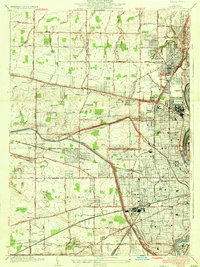 1935 Rochester West1935 Print · USGSWestern Rochester and the towns of Greece and Gates are shown in the mid-1930s during a peak era of industrial and institutional growth. Researchers can trace the massive footprint of Kodak Park, the old rail lines at Coldwater Sta, and local landmarks like Holy Sepulchre Cemetery.2 unique versions available
End of results
Showing maps 1-2 of 2
Frequently asked questions
- What are the different types of historical maps available for Lyell-Otis?
- What is the oldest map of Lyell-Otis?
- Where can I purchase historical maps of Lyell-Otis for my home or office?
- Where can I download high-res historical maps of Lyell-Otis?
- Are there historical topographic maps available for Lyell-Otis?
- Is there historical aerial imagery available for Lyell-Otis?
- Where are historical maps of Lyell-Otis sourced from?