1890s Maps of Oneida County, New York
Explore 8 historic maps of Oneida County from the 1890s. These maps offer a rare glimpse into what life looked like during the 1890s — showing old roads, neighborhoods, homes, and landmarks that have changed or disappeared over time.
Whether you're researching your family's past, planning a metal detecting trip, or studying how Oneida County's landscape evolved across the 1890s, these high-resolution maps are a powerful tool for exploring the history of this region.
- Focus on a specific era: All maps on this page are from the 1890s, giving you a focused view of this time period.
- See what’s changed: Compare century-old streets, trails, and buildings to today's modern landscape using overlays and satellite layers.
- Research with precision: Use these maps for genealogy, historical research, land use analysis, or educational projects.
- View, download, or print: Maps are fully viewable online in high resolution, and can be downloaded or printed for your own records.
Start exploring Oneida County's history through authentic maps from the 1890s. This is your window into the past.
Oneida County, NY maps
(8)- 1895 Map of Chittenango
 1895 Chittenango1895 Print · USGSMadison County and the southern shores of Oneida Lake are shown here at the height of the canal and rail era. Researchers can trace the path of the Erie Canal through Chittenango and Canastota or locate vanished sites like Fyler Settlement.
 - 1895 Map of Oriskany
 1895 Oriskany1895 Print · USGSOneida County at the end of the nineteenth century reveals a landscape defined by the great Mohawk valley canals and emerging industrial hamlets. Researchers can trace the path of the Erie Canal, find the Franklin Iron Works, and locate early educational landmarks like College Hill.
 - 1895 Map of Oneida
 1895 Oneida1895 Print · USGSIn the 1890s, the landscape around Oneida was a busy hub of canal engineering and railway expansion. Genealogists and historians can trace the evolution of the Erie Canal, find the storied Oneida Community, or locate the historic site of Fort Bull.
 - 1897 Map of Remsen, 1958 Print
 1897 Remsen1958 Print · USGSOneida and Herkimer Counties are shown in the late 19th century as bustling timber and transit hubs before the modernization of the canal system. Local historians can trace the vital rail junctions at Remsen and the water-powered industrial sites like Bardwell Mill and Trenton Falls.
 - 1898 Map of Oneida
 1898 Oneida1898 Print · USGSCentral New York at the end of the nineteenth century served as a vital crossroads of early American industry and canal technology. Genealogists and historians can trace the footprint of the Oneida Community, the fortifications of Fort Bull, and the intricate paths of the Erie Canal and Old Oneida Lake Canal.
 - 1898 Map of Chittenango
 1898 Chittenango1898 Print · USGSThe northern shore of Oneida Lake and the bustling Erie Canal corridor are captured here during the peak of New York's rail expansion. Researchers can trace the original canal path through Chittenango or locate vanished stops along the West Shore R. R. and Elmira and Cortland Br.
 - 1898 Map of Utica
 1898 Utica1898 Print · USGSThe Mohawk Valley was a powerhouse of industry and transport at the end of the Victorian era. Trace the path of the Erie Canal through Utica, or locate family homesteads near Barker Corners, Sheaf Corners, and Poland.
 - 1898 Map of Oriskany
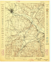 1898 Oriskany1898 Print · USGSOneida County at the close of the nineteenth century reveals a landscape defined by the intersection of the Erie Canal and major rail lines. Genealogists can trace family homes in Spencer Settlement, locate industrial sites like Hecla Works, or find the historic Oriskany Battle Monument.10 unique versions available
End of results
Showing maps 1-8 of 8
Top cities of Oneida County
- Utica historical maps
- Rome historical maps
- New Hartford historical maps
- Whitestown historical maps
- Kirkland historical maps
- Marcy historical maps
See more
Frequently asked questions
- What are the different types of historical maps available for Oneida County?
- What is the oldest map of Oneida County?
- Where can I purchase historical maps of Oneida County for my home or office?
- Where can I download high-res historical maps of Oneida County?
- Are there historical topographic maps available for Oneida County?
- Is there historical aerial imagery available for Oneida County?
- Where are historical maps of Oneida County sourced from?