1940s Maps of Woodhull, Forestport
Explore 2 historic maps of Woodhull from the 1940s. These maps offer a rare glimpse into what life looked like during the 1940s — showing old roads, neighborhoods, homes, and landmarks that have changed or disappeared over time.
Whether you're researching your family's past, planning a metal detecting trip, or studying how Woodhull's landscape evolved across the 1940s, these high-resolution maps are a powerful tool for exploring the history of this region.
- Focus on a specific era: All maps on this page are from the 1940s, giving you a focused view of this time period.
- See what’s changed: Compare century-old streets, trails, and buildings to today's modern landscape using overlays and satellite layers.
- Research with precision: Use these maps for genealogy, historical research, land use analysis, or educational projects.
- View, download, or print: Maps are fully viewable online in high resolution, and can be downloaded or printed for your own records.
Start exploring Woodhull's history through authentic maps from the 1940s. This is your window into the past.
Woodhull, Forestport maps
(2)- 1945 Map of Forestport, 1958 Print
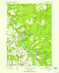 1945 Forestport1958 Print · USGSOneida County's Adirondack fringe comes into focus at the close of the war years, centered on the river-fed industry of the Black River valley. Genealogists and historians can trace rail-era landmarks like Forestport Station, Bardwell Mill, and Bethel Ch.4 unique versions available
 - 1947 Map of Forestport
 1947 Forestport1947 Print · USGSOneida County in the late 1940s centers on the critical water routes of the Black River and the bustling rail corridor. Local historians can trace the foundations of Forestport, explore the grounds of Bardwell Mill, or locate family sites at Bethel Ch and Brooks Cem.2 unique versions available
End of results
Showing maps 1-2 of 2
Top cities near Woodhull
- Rome historical maps
- Marcy historical maps
- Boonville historical maps
- Trenton historical maps
- Deerfield historical maps
- Floyd historical maps
See more
Frequently asked questions
- What are the different types of historical maps available for Woodhull?
- What is the oldest map of Woodhull?
- Where can I purchase historical maps of Woodhull for my home or office?
- Where can I download high-res historical maps of Woodhull?
- Are there historical topographic maps available for Woodhull?
- Is there historical aerial imagery available for Woodhull?
- Where are historical maps of Woodhull sourced from?