1930s Maps of Salina, New York
Explore 2 historic maps of Salina from the 1930s. These maps offer a rare glimpse into what life looked like during the 1930s — showing old roads, neighborhoods, homes, and landmarks that have changed or disappeared over time.
Whether you're researching your family's past, planning a metal detecting trip, or studying how Salina's landscape evolved across the 1930s, these high-resolution maps are a powerful tool for exploring the history of this region.
- Focus on a specific era: All maps on this page are from the 1930s, giving you a focused view of this time period.
- See what’s changed: Compare century-old streets, trails, and buildings to today's modern landscape using overlays and satellite layers.
- Research with precision: Use these maps for genealogy, historical research, land use analysis, or educational projects.
- View, download, or print: Maps are fully viewable online in high resolution, and can be downloaded or printed for your own records.
Start exploring Salina's history through authentic maps from the 1930s. This is your window into the past.
Salina, NY maps
(2)- 1938 Map of Syracuse East
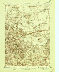 1938 Syracuse East1938 Print · USGSOnondaga County in the late 1930s shows a landscape of rail yards and growing suburban hamlets. Researchers can trace the industrial footprint of the New York Central Yards or locate local landmarks like the Orphans Home and St Marys Cemetery.2 unique versions available
 - 1939 Map of Syracuse West
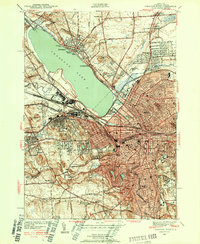 1939 Syracuse West1939 Print · USGSSyracuse and its surrounding townships show the height of the pre-war industrial era as the city expands toward the shores of Onondaga Lake. Genealogists and historians can trace the foundations of the community through the Erie Canal (Abandoned), the Salt Museum, and Syracuse University.3 unique versions available
End of results
Showing maps 1-2 of 2
Top cities near Salina
- Syracuse historical maps
- Clay historical maps
- Manlius historical maps
- Cicero historical maps
- De Witt historical maps
- DeWitt historical maps
See more
Top neighborhoods of Salina
- Pitcher Hill historical maps
- Long Branch historical maps
- Mattydale historical maps
- Galeville historical maps
- Lyncourt historical maps
- Liverpool historical maps
See more
Frequently asked questions
- What are the different types of historical maps available for Salina?
- What is the oldest map of Salina?
- Where can I purchase historical maps of Salina for my home or office?
- Where can I download high-res historical maps of Salina?
- Are there historical topographic maps available for Salina?
- Is there historical aerial imagery available for Salina?
- Where are historical maps of Salina sourced from?