1950s Maps of Highlands, New York
Explore 7 historic maps of Highlands from the 1950s. These maps offer a rare glimpse into what life looked like during the 1950s — showing old roads, neighborhoods, homes, and landmarks that have changed or disappeared over time.
Whether you're researching your family's past, planning a metal detecting trip, or studying how Highlands's landscape evolved across the 1950s, these high-resolution maps are a powerful tool for exploring the history of this region.
- Focus on a specific era: All maps on this page are from the 1950s, giving you a focused view of this time period.
- See what’s changed: Compare century-old streets, trails, and buildings to today's modern landscape using overlays and satellite layers.
- Research with precision: Use these maps for genealogy, historical research, land use analysis, or educational projects.
- View, download, or print: Maps are fully viewable online in high resolution, and can be downloaded or printed for your own records.
Start exploring Highlands's history through authentic maps from the 1950s. This is your window into the past.
Highlands, NY maps
(7)- 1950 Map of Scranton, 1952 Print
 1950 Scranton1952 Print · USGSMid-century Northeast Pennsylvania and the Hudson Valley come alive in this survey of the tri-state region. Genealogists and historians can trace the dense rail networks of the Erie RR and DL&W RR between industrial hubs like Scranton and Wilkes-Barre.
 - 1953 Map of Scranton
 1953 Scranton1953 Print · USGSNortheastern Pennsylvania and the Catskills are shown in great detail during the early fifties, a time when rail lines and river valleys dictated the region's growth. Genealogists and historians can trace the industrial hearts of Scranton and Wilkes-Barre or locate remote landmarks like High Point and Lake Wallenpaupack.
 - 1957 Map of Peekskill, 1959 Print
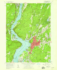 1957 Peekskill1959 Print · USGSThe Hudson Highlands and Peekskill waterfront are captured here in the late fifties, showcasing a landscape of river-borne industry and established institutions. Researchers can trace historic cemeteries and schools such as Hillside Cemetery, Ladycliff College, and the National Guard Armory.6 unique versions available
 - 1957 Map of Cornwall, 1959 Print
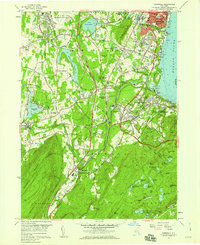 1957 Cornwall1959 Print · USGSThe western banks of the Hudson River thrive in the late fifties, where industrial towns meet military outposts and mountain parks. Genealogists can trace family roots at Woodlawn Cemetery or locate historic sites like Orrs Mill and Knox Headquarters.5 unique versions available
 - 1957 Map of Popolopen Lake, 1959 Print
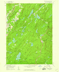 1957 Popolopen Lake1959 Print · USGSThe Hudson Highlands in the late fifties show a landscape of military grounds and public forest just as the modern thruway era arrived. Researchers can locate the historic Quaker Meetinghouse, trace the original Appalachian Trail route, and find settlements like Doodletown and Barleytown.5 unique versions available
 - 1957 Map of West Point, 1965 Print
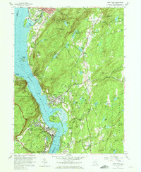 1957 West Point1965 Print · USGSThe Hudson Highlands were a hub of military education and river-bound industry during the late fifties. You can trace the detailed campus of the U S Military Academy at West Point, explore the streets of Cold Spring, and locate the U S Silver Depository.4 unique versions available
 - 1959 Map of Scranton
 1959 Scranton1959 Print · USGSThe northern coalfields and the Hudson Valley meet in this mid-century survey of the Pennsylvania and New York borderlands. Genealogists and historians can trace the intricate rail networks of the Erie Railroad and the vast waters of Lake Wallenpaupack.2 unique versions available
End of results
Showing maps 1-7 of 7
Top cities near Highlands
- Ramapo historical maps
- Clarkstown historical maps
- Poughkeepsie historical maps
- Mount Pleasant historical maps
- Cortlandt historical maps
- Ossining historical maps
See more
Top neighborhoods of Highlands
Frequently asked questions
- What are the different types of historical maps available for Highlands?
- What is the oldest map of Highlands?
- Where can I purchase historical maps of Highlands for my home or office?
- Where can I download high-res historical maps of Highlands?
- Are there historical topographic maps available for Highlands?
- Is there historical aerial imagery available for Highlands?
- Where are historical maps of Highlands sourced from?