1970s Maps of Orleans County, New York
Explore 5 historic maps of Orleans County from the 1970s. These maps offer a rare glimpse into what life looked like during the 1970s — showing old roads, neighborhoods, homes, and landmarks that have changed or disappeared over time.
Whether you're researching your family's past, planning a metal detecting trip, or studying how Orleans County's landscape evolved across the 1970s, these high-resolution maps are a powerful tool for exploring the history of this region.
- Focus on a specific era: All maps on this page are from the 1970s, giving you a focused view of this time period.
- See what’s changed: Compare century-old streets, trails, and buildings to today's modern landscape using overlays and satellite layers.
- Research with precision: Use these maps for genealogy, historical research, land use analysis, or educational projects.
- View, download, or print: Maps are fully viewable online in high resolution, and can be downloaded or printed for your own records.
Start exploring Orleans County's history through authentic maps from the 1970s. This is your window into the past.
Orleans County, NY maps
(5)- 1971 Map of Hamlin, 1973 Print
 1971 Hamlin1973 Print · USGSThe Lake Ontario shoreline near Hamlin and Kendall Mills is captured here in the early 1970s as a quiet agricultural and recreational corridor. Researchers can trace family history through local landmarks like St Johns Sch, Lakeside Cem, and the path of the Penn Central railroad.
 - 1971 Map of Brockport, 1973 Print
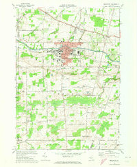 1971 Brockport1973 Print · USGSBrockport and the surrounding township of Sweden are captured here in the early seventies, centered on the historic canal and a growing university campus. Genealogists can trace family names across Lake View Cemetery or search for ancestral roots in West Sweden and Clarkson.2 unique versions available
 - 1978 Map of Hamlin
 1978 Hamlin1978 Print · USGSMonroe County's lakeshore and farming hinterlands are captured here in the late seventies. Researchers can trace rural lineages through the locations of Lakeside Cem, St Johns Sch, and established crossroads like Morton and Kendall Mills.
 - 1978 Map of Kendall, 1979 Print
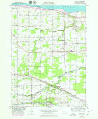 1978 Kendall1979 Print · USGSOrleans County orchards and lakefront cottages thrive in the late 1970s between the Great Lakes shoreline and the historic canal. Genealogists can trace family names through Greenwood Cem and Murray Cem or locate rural landmarks like School No 11 and Brockville.
 - 1979 Map of Lyndonville, 1980 Print
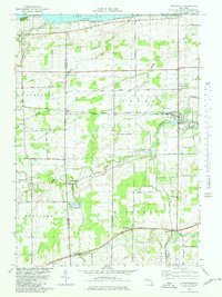 1979 Lyndonville1980 Print · USGSOrchard lands and small crossroads settlements define this Lake Ontario shoreline in the late seventies. Genealogists and local historians can trace property locations and community landmarks from Lyndonville and Jeddo to Somerset Cem and St Johns Ch.
End of results
Showing maps 1-5 of 5
Top cities of Orleans County
- Albion historical maps
- Ridgeway historical maps
- Medina historical maps
- Albion historical maps
- Shelby historical maps
- Murray historical maps
See more
Frequently asked questions
- What are the different types of historical maps available for Orleans County?
- What is the oldest map of Orleans County?
- Where can I purchase historical maps of Orleans County for my home or office?
- Where can I download high-res historical maps of Orleans County?
- Are there historical topographic maps available for Orleans County?
- Is there historical aerial imagery available for Orleans County?
- Where are historical maps of Orleans County sourced from?