1940s Maps of Carlton, New York
Explore 2 historic maps of Carlton from the 1940s. These maps offer a rare glimpse into what life looked like during the 1940s — showing old roads, neighborhoods, homes, and landmarks that have changed or disappeared over time.
Whether you're researching your family's past, planning a metal detecting trip, or studying how Carlton's landscape evolved across the 1940s, these high-resolution maps are a powerful tool for exploring the history of this region.
- Focus on a specific era: All maps on this page are from the 1940s, giving you a focused view of this time period.
- See what’s changed: Compare century-old streets, trails, and buildings to today's modern landscape using overlays and satellite layers.
- Research with precision: Use these maps for genealogy, historical research, land use analysis, or educational projects.
- View, download, or print: Maps are fully viewable online in high resolution, and can be downloaded or printed for your own records.
Start exploring Carlton's history through authentic maps from the 1940s. This is your window into the past.
Carlton, NY maps
(2)- 1944 Map of Ashwood
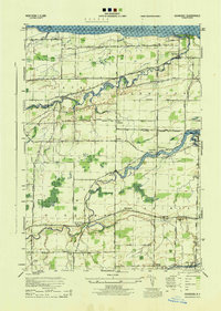 1944 Ashwood1944 Print · USGSOrleans County orchards and waterways meet the shoreline of Lake Ontario during the mid-forties. Genealogists can trace family roots through numerous local landmarks, including Oak Orchard Cem, Eagle Harbor on the Erie Canal, and scattered district schools.
 - 1949 Map of Kendall, 1956 Print
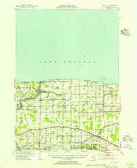 1949 Kendall1956 Print · USGSOrleans County at the close of the 1940s shows a landscape defined by the fruit belt of the lake plain and the historic transit lines of the south. Researchers can trace the path of the Erie Canal through Hindsburg or locate early rural schoolhouses like School No 6 and School No 12.
End of results
Showing maps 1-2 of 2
Top cities near Carlton
- Sweden historical maps
- Hamlin historical maps
- Albion historical maps
- Clarkson historical maps
- Ridgeway historical maps
- Medina historical maps
See more
Top neighborhoods of Carlton
- Kuckville historical maps
- Lakeside Park historical maps
- Sunset Beach historical maps
- Waterport historical maps
- Kenyonville historical maps
- Point Breeze historical maps
See more
Frequently asked questions
- What are the different types of historical maps available for Carlton?
- What is the oldest map of Carlton?
- Where can I purchase historical maps of Carlton for my home or office?
- Where can I download high-res historical maps of Carlton?
- Are there historical topographic maps available for Carlton?
- Is there historical aerial imagery available for Carlton?
- Where are historical maps of Carlton sourced from?