1940s Maps of Burlington, New York
Explore 9 historic maps of Burlington from the 1940s. These maps offer a rare glimpse into what life looked like during the 1940s — showing old roads, neighborhoods, homes, and landmarks that have changed or disappeared over time.
Whether you're researching your family's past, planning a metal detecting trip, or studying how Burlington's landscape evolved across the 1940s, these high-resolution maps are a powerful tool for exploring the history of this region.
- Focus on a specific era: All maps on this page are from the 1940s, giving you a focused view of this time period.
- See what’s changed: Compare century-old streets, trails, and buildings to today's modern landscape using overlays and satellite layers.
- Research with precision: Use these maps for genealogy, historical research, land use analysis, or educational projects.
- View, download, or print: Maps are fully viewable online in high resolution, and can be downloaded or printed for your own records.
Start exploring Burlington's history through authentic maps from the 1940s. This is your window into the past.
Burlington, NY maps
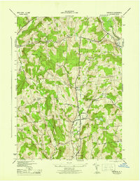
(9)- 1943 Map of Schuyler Lake, 1953 Print
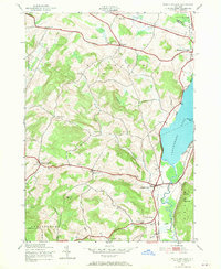 1943 Schuyler Lake1953 Print · USGSOtsego County in the early 1940s is captured here, showing the transition from lakeside resorts to upland dairy country. Researchers can trace historic district schools like Ryder Sch and find family plots in Exeter Cem or Herkimer Cem.3 unique versions available
 - 1943 Map of Unadilla Forks, 1960 Print
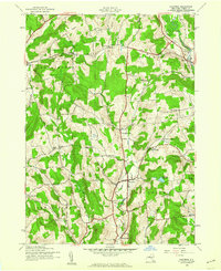
 1943 Unadilla Forks1960 Print · USGSThe central New York uplands come into focus in the 1940s at the junction of four counties. Genealogists can trace family landmarks like Beverly Inn Corners, Spooner Corners, and the Taylor Hill Cem.2 unique versions available
 - 1943 Map of Edmeston, 1960 Print
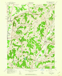
 1943 Edmeston1960 Print · USGSThis Otsego County landscape during the early 1940s shows a classic New York dairy and farming region defined by creek-side hamlets and hill farms. Researchers can locate many family sites via Union Cem, School No 12, and settlements like Burlington Flats.3 unique versions available
 - 1943 Map of Hartwick, 1960 Print
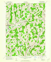
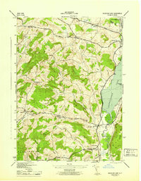
 1943 Hartwick1960 Print · USGSCentral Otsego County is shown here in the mid-1940s, a landscape defined by small dairy farms and creek-side hamlets. Researchers can locate numerous local landmarks including the Whitehouse Sch, Robinson Cem, and the waters of Hartwick Reservoir.4 unique versions available
 - 1945 Map of Hartwick
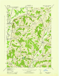
 1945 Hartwick1945 Print · USGSOtsego County's rural heartland is meticulously documented in the mid-1940s, showing a landscape of upland farms and small hamlets. Genealogists can trace family footprints at Maple Cem or locate vanished local schools like Texas Sch and Briar Hill Sch.
 - 1945 Map of Schuyler Lake
 1945 Schuyler Lake1945 Print · USGSOtsego County's farming valleys and upland ridges are captured here during the mid-1940s. Researchers can trace historic turnpikes, old district schools like Cobblestone Sch, and family burial grounds such as Twilight Rest Cem.
 - 1945 Map of Unadilla Forks
 1945 Unadilla Forks1945 Print · USGSThe Unadilla River valley during the 1940s reveals a landscape of high ridges and active rail-side settlements at the intersection of three counties. Local historians can trace the development of hamlets like Leonardsville and West Exeter, or locate rural landmarks such as School No 8 and Wood Cem.
 - 1945 Map of Edmeston
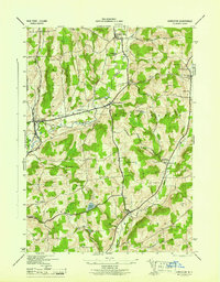 1945 Edmeston1945 Print · USGSOtsego County's rural character is preserved here in the mid-1940s, showing the settled valleys of the Pittsfield and Burlington areas. Genealogists can trace family roots through sites like Quaker Cem, Gross Hill Sch, and hamlets like Garrattsville.
 - 1948 Map of Binghamton, 1980 Print
 1948 Binghamton1980 Print · USGSCentral New York and the Southern Tier thrive in the late 1940s as a hub of rail traffic and mountain industry. Researchers can trace historic transit lines like the Erie Railroad through Binghamton or find old valley settlements near Oneonta and Delhi.
End of results
Showing maps 1-9 of 9
Top cities near Burlington
- German Flatts historical maps
- Oneonta historical maps
- Paris historical maps
- Otsego historical maps
- Davenport historical maps
- Milford historical maps
See more
Top neighborhoods of Burlington
- Pecktown historical maps
- West Burlington historical maps
- Barrett Corners historical maps
- Patent historical maps
- Burlington Flats historical maps
Frequently asked questions
- What are the different types of historical maps available for Burlington?
- What is the oldest map of Burlington?
- Where can I purchase historical maps of Burlington for my home or office?
- Where can I download high-res historical maps of Burlington?
- Are there historical topographic maps available for Burlington?
- Is there historical aerial imagery available for Burlington?
- Where are historical maps of Burlington sourced from?