1910s Maps of Morris, New York
Explore 8 historic maps of Morris from the 1910s. These maps offer a rare glimpse into what life looked like during the 1910s — showing old roads, neighborhoods, homes, and landmarks that have changed or disappeared over time.
Whether you're researching your family's past, planning a metal detecting trip, or studying how Morris's landscape evolved across the 1910s, these high-resolution maps are a powerful tool for exploring the history of this region.
- Focus on a specific era: All maps on this page are from the 1910s, giving you a focused view of this time period.
- See what’s changed: Compare century-old streets, trails, and buildings to today's modern landscape using overlays and satellite layers.
- Research with precision: Use these maps for genealogy, historical research, land use analysis, or educational projects.
- View, download, or print: Maps are fully viewable online in high resolution, and can be downloaded or printed for your own records.
Start exploring Morris's history through authentic maps from the 1910s. This is your window into the past.
Morris, NY maps
(8)- 1910 Map of Hartwick, 1953 Print
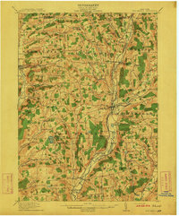
 1910 Hartwick1953 Print · USGSOtsego County's rural landscape is meticulously detailed during the early twentieth century, showing a world of hillside farms and valley hamlets. Genealogists and historians can trace old homesteads and transport routes like the O & W RR near Mt Vision and South Hartwick.
 - 1910 Map of New Berlin, 1963 Print
 1910 New Berlin1963 Print · USGSThe Unadilla and Chenango river valleys are seen here in the early twentieth century as established rail corridors and farming hubs. Researchers can trace the N Y O & W R R line through Holmesville or locate family sites like Kings Settlement and the Dimmick Hollow School.
 - 1912 Map of New Berlin
 1912 New Berlin1912 Print · USGSChenango County's river valleys and dairy uplands are meticulously captured in this pre-war survey of the New Berlin area. Genealogists can locate family-named landmarks and institutions like Columbus Hill Church, Kings Settlement, and the Dimmick Hollow School.4 unique versions available
 - 1912 Map of Hartwick
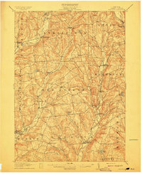 1912 Hartwick1912 Print · USGSOtsego County's rural heartland is captured here at the height of its rail-and-river economy in the years before the Great War. Genealogists can trace family homesteads near Burlington Flats, New Lisbon, and the tracks of the O & H Electric line.4 unique versions available
 - 1915 Map of Oneonta
 1915 Oneonta1915 Print · USGSOtsego and Delaware counties thrived at this moment in the early twentieth century as a busy corridor for the Ulster and Delaware railroad. Genealogists and local historians can trace family-named schoolhouses and the agricultural economy at Arctic Creamery or the rural Franklin Depot.
 - 1915 Map of Unadilla, 1961 Print
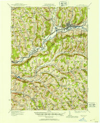
 1915 Unadilla1961 Print · USGSThe river valleys of Chenango and Delaware counties are shown here during the height of the steam rail era. Researchers can trace the New York Ontario and Western lines through Sidney and Bainbridge, or locate the Friends Meeting House and dozens of rural schoolhouses.
 - 1918 Map of Unadilla
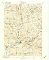 1918 Unadilla1918 Print · USGSThe Susquehanna and Unadilla river valleys come alive during the years of World War I, showing a landscape of bustling rail junctions and riverside villages. Genealogists can trace family names at Lathams Corners or locate the Friends Meeting House and Sodom School.6 unique versions available
 - 1918 Map of Oneonta
 1918 Oneonta1918 Print · USGSOneonta and the Susquehanna valley are captured here at a peak of rail-driven commerce during the early twentieth century. Genealogists and historians can locate scores of numbered country schools and rural landmarks like the Arctic Creamery, Wells Bridge, and Franklin Depot.3 unique versions available
End of results
Showing maps 1-8 of 8
Top cities near Morris
- Oneonta historical maps
- Hamilton historical maps
- Sidney historical maps
- Oneonta historical maps
- Unadilla historical maps
- Sherburne historical maps
See more
Top neighborhoods of Morris
Frequently asked questions
- What are the different types of historical maps available for Morris?
- What is the oldest map of Morris?
- Where can I purchase historical maps of Morris for my home or office?
- Where can I download high-res historical maps of Morris?
- Are there historical topographic maps available for Morris?
- Is there historical aerial imagery available for Morris?
- Where are historical maps of Morris sourced from?