1940s Maps of Welcome, New Lisbon
Explore 3 historic maps of Welcome from the 1940s. These maps offer a rare glimpse into what life looked like during the 1940s — showing old roads, neighborhoods, homes, and landmarks that have changed or disappeared over time.
Whether you're researching your family's past, planning a metal detecting trip, or studying how Welcome's landscape evolved across the 1940s, these high-resolution maps are a powerful tool for exploring the history of this region.
- Focus on a specific era: All maps on this page are from the 1940s, giving you a focused view of this time period.
- See what’s changed: Compare century-old streets, trails, and buildings to today's modern landscape using overlays and satellite layers.
- Research with precision: Use these maps for genealogy, historical research, land use analysis, or educational projects.
- View, download, or print: Maps are fully viewable online in high resolution, and can be downloaded or printed for your own records.
Start exploring Welcome's history through authentic maps from the 1940s. This is your window into the past.
Welcome, New Lisbon maps
(3)- 1943 Map of Morris, 1960 Print
 1943 Morris1960 Print · USGSOtsego County during the early 1940s reveals a landscape of high ridges and winding creek valleys dotted with family homesteads and rural hamlets. Researchers can locate numerous historic burial sites like Old Church Cem and trace the early development of Gilbert Lake State Park.3 unique versions available
 - 1945 Map of Morris
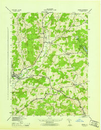 1945 Morris1945 Print · USGSOtsego County's rural valleys and hill farms are captured here just after the war, centered on the village of Morris. Researchers can locate numerous family burial grounds like Lull Cem and trace the original footprints of hamlets like New Lisbon and Welcome.
 - 1948 Map of Binghamton, 1980 Print
 1948 Binghamton1980 Print · USGSCentral New York and the Southern Tier thrive in the late 1940s as a hub of rail traffic and mountain industry. Researchers can trace historic transit lines like the Erie Railroad through Binghamton or find old valley settlements near Oneonta and Delhi.
End of results
Showing maps 1-3 of 3
Top cities near Welcome
- Oneonta historical maps
- Oneonta historical maps
- Unadilla historical maps
- Otsego historical maps
- Davenport historical maps
- Milford historical maps
See more
Frequently asked questions
- What are the different types of historical maps available for Welcome?
- What is the oldest map of Welcome?
- Where can I purchase historical maps of Welcome for my home or office?
- Where can I download high-res historical maps of Welcome?
- Are there historical topographic maps available for Welcome?
- Is there historical aerial imagery available for Welcome?
- Where are historical maps of Welcome sourced from?