1940s Maps of Richfield, New York
Explore 13 historic maps of Richfield from the 1940s. These maps offer a rare glimpse into what life looked like during the 1940s — showing old roads, neighborhoods, homes, and landmarks that have changed or disappeared over time.
Whether you're researching your family's past, planning a metal detecting trip, or studying how Richfield's landscape evolved across the 1940s, these high-resolution maps are a powerful tool for exploring the history of this region.
- Focus on a specific era: All maps on this page are from the 1940s, giving you a focused view of this time period.
- See what’s changed: Compare century-old streets, trails, and buildings to today's modern landscape using overlays and satellite layers.
- Research with precision: Use these maps for genealogy, historical research, land use analysis, or educational projects.
- View, download, or print: Maps are fully viewable online in high resolution, and can be downloaded or printed for your own records.
Start exploring Richfield's history through authentic maps from the 1940s. This is your window into the past.
Richfield, NY maps
(13)- 1943 Map of Schuyler Lake, 1953 Print
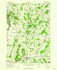
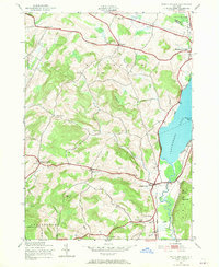 1943 Schuyler Lake1953 Print · USGSOtsego County in the early 1940s is captured here, showing the transition from lakeside resorts to upland dairy country. Researchers can trace historic district schools like Ryder Sch and find family plots in Exeter Cem or Herkimer Cem.3 unique versions available
 - 1943 Map of Richfield Springs, 1960 Print
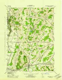
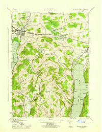
 1943 Richfield Springs1960 Print · USGSUpper Otsego County is shown here during the early 1940s, centered on the historic rail and water junctions of the Leatherstocking Country. Genealogists can trace family names through numbered schoolhouses like School No 10 and cemeteries such as Lakeview Cem.2 unique versions available
 - 1943 Map of Millers Mills, 1960 Print
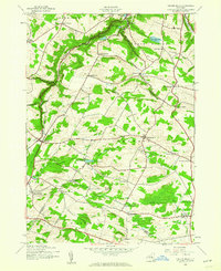 1943 Millers Mills1960 Print · USGSHerkimer County's rural townships and glacial ravines appear in detail in this mid-century survey. Researchers can trace the path of the Delaware Lackawanna and Western railroad through local stops like Millers Mills and Cedarville Station.2 unique versions available
 - 1943 Map of Unadilla Forks, 1960 Print
 1943 Unadilla Forks1960 Print · USGSThe central New York uplands come into focus in the 1940s at the junction of four counties. Genealogists can trace family landmarks like Beverly Inn Corners, Spooner Corners, and the Taylor Hill Cem.2 unique versions available
 - 1943 Map of West Winfield, 1960 Print
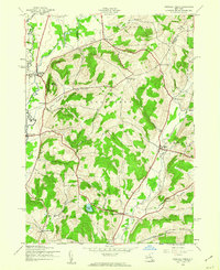
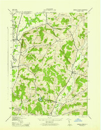
 1943 West Winfield1960 Print · USGSThe rural dairy country of central New York comes into focus during the mid-century as the rail corridor and headwaters of the Unadilla River shape the local economy. Genealogists can trace family names at Days Corners or locate historic sites like Meeting House Green and St Marys Cem.3 unique versions available
 - 1945 Map of Millers Mills
 1945 Millers Mills1945 Print · USGSThe upland dairy country of Herkimer and Otsego Counties is captured here in the mid-1940s, showing a landscape of small hamlets and district schools. Researchers can trace the Delaware Lackawanna and Western rail line through Millers Mills or find family plots at Conrad Helmer Cem and Brown-Young Cem.
 - 1945 Map of Schuyler Lake
 1945 Schuyler Lake1945 Print · USGSOtsego County's farming valleys and upland ridges are captured here during the mid-1940s. Researchers can trace historic turnpikes, old district schools like Cobblestone Sch, and family burial grounds such as Twilight Rest Cem.
 - 1945 Map of West Winfield
 1945 West Winfield1945 Print · USGSThe northern headwaters of the Unadilla River and the rural borders of Oneida and Herkimer counties are frozen in time just as the war ended. Genealogists can trace family names and sites across West Winfield, Meeting House Green, and St Marys Cem.
 - 1945 Map of Unadilla Forks
 1945 Unadilla Forks1945 Print · USGSThe Unadilla River valley during the 1940s reveals a landscape of high ridges and active rail-side settlements at the intersection of three counties. Local historians can trace the development of hamlets like Leonardsville and West Exeter, or locate rural landmarks such as School No 8 and Wood Cem.
 - 1945 Map of Richfield Springs
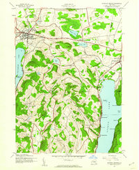
 1945 Richfield Springs1945 Print · USGSRichfield Springs and its surrounding dairy country are captured here at the end of the war, as the D L & W railroad still served the village core. Researchers can locate many small rural schoolhouses like School No 10 and cemeteries such as Marshall Cem scattered throughout the hills near Rum Hill.
 - 1946 Map of Millers Mills
 1946 Millers Mills1946 Print · USGSThe Herkimer and Otsego county borderlands are captured here in the mid-1940s, showing a rural landscape defined by deep ravines and small farming hamlets. Researchers can trace family history through sites like Millers Mills, Conrad Helmer Cem, and the Richfield Hill School.
 - 1948 Map of Binghamton, 1980 Print
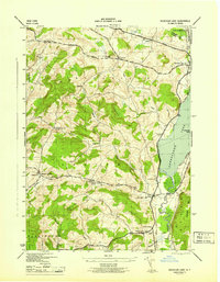
 1948 Binghamton1980 Print · USGSCentral New York and the Southern Tier thrive in the late 1940s as a hub of rail traffic and mountain industry. Researchers can trace historic transit lines like the Erie Railroad through Binghamton or find old valley settlements near Oneonta and Delhi.
 - 1949 Map of Millers Mills
 1949 Millers Mills1949 Print · USGSPost-war Herkimer County is captured here at a time when small crossroads settlements and family farmsteads still defined the central New York countryside. Researchers can trace the Lackawanna rail line through Millers Mills and locate ancestral sites like Conrad Helmer Cem or Fern Cliff School.
End of results
Showing maps 1-13 of 13
Top cities near Richfield
- Utica historical maps
- New Hartford historical maps
- German Flatts historical maps
- Herkimer historical maps
- Ilion historical maps
- Herkimer historical maps
See more
Top neighborhoods of Richfield
Frequently asked questions
- What are the different types of historical maps available for Richfield?
- What is the oldest map of Richfield?
- Where can I purchase historical maps of Richfield for my home or office?
- Where can I download high-res historical maps of Richfield?
- Are there historical topographic maps available for Richfield?
- Is there historical aerial imagery available for Richfield?
- Where are historical maps of Richfield sourced from?