1990s Maps of Queens County, New York
Explore 6 historic maps of Queens County from the 1990s. These maps offer a rare glimpse into what life looked like during the 1990s — showing old roads, neighborhoods, homes, and landmarks that have changed or disappeared over time.
Whether you're researching your family's past, planning a metal detecting trip, or studying how Queens County's landscape evolved across the 1990s, these high-resolution maps are a powerful tool for exploring the history of this region.
- Focus on a specific era: All maps on this page are from the 1990s, giving you a focused view of this time period.
- See what’s changed: Compare century-old streets, trails, and buildings to today's modern landscape using overlays and satellite layers.
- Research with precision: Use these maps for genealogy, historical research, land use analysis, or educational projects.
- View, download, or print: Maps are fully viewable online in high resolution, and can be downloaded or printed for your own records.
Start exploring Queens County's history through authentic maps from the 1990s. This is your window into the past.
Queens County, NY maps
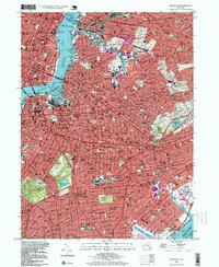
(6)- 1994 Map of Jamaica, 2000 Print
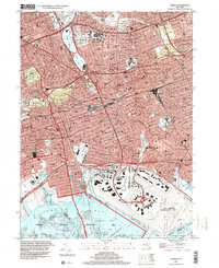 1994 Jamaica2000 Print · USGSCentral Queens in the 1990s reveals a dense network of neighborhoods, major transit corridors, and massive coastal infrastructure. Trace local landmarks from Aqueduct Racetrack and St Johns University to the historic Bayside Cem.
 - 1995 Map of Flushing, 1999 Print
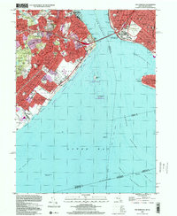
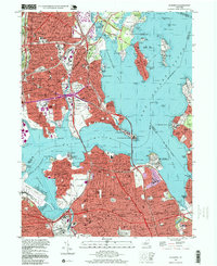 1995 Flushing1999 Print · USGSThe coastal stretches of the Bronx and Queens are captured here in the mid-nineties, showing the dense residential growth and massive bridge infrastructure of the era. Researchers can trace historic institutions and local landmarks like Shea Stadium, Fort Totten Mil Reservation, and St Raymonds Cemetery.
 - 1995 Map of Central Park, 1999 Print
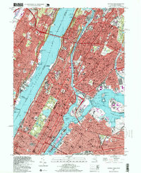 1995 Central Park1999 Print · USGSGreater New York is captured in the late twentieth century, showing the dense intersection of Manhattan, the Bronx, Queens, and the Jersey Palisades. Genealogists and historians can trace neighborhood boundaries from Mott Haven to Edgewater, while identifying major landmarks like St Michaels Cemetery and Yankee Stadium.
 - 1995 Map of Coney Island, 1999 Print
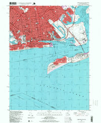 1995 Coney Island1999 Print · USGSSouthern Brooklyn and the Rockaway Peninsula are captured here in the mid-nineties, showing the dense residential neighborhoods of Brighton Beach and Gravesend. Genealogists and local historians can trace landmarks like Washington Cemetery, Steeplechase Pier, and the sprawling Brooklyn Marine Park.
 - 1995 Map of Brooklyn, 1999 Print
 1995 Brooklyn1999 Print · USGSBrooklyn and western Queens are shown in high detail during the mid-nineties, capturing the dense intersection of transit and community. Researchers can trace historic neighborhood boundaries from Bushwick to Canarsie, identifying local landmarks like Pratt Institute and Brooklyn College.
 - 1998 Map of The Narrows, 2001 Print
 1998 The Narrows2001 Print · USGSStaten Island and Brooklyn meet at the harbor entrance during the late nineties, featuring a fully developed network of residential neighborhoods and coastal parks. Genealogists and local historians can locate Moravian Cemetery, St Marys Cem, and the historic transit line through New Dorp.
End of results
Showing maps 1-6 of 6
Frequently asked questions
- What are the different types of historical maps available for Queens County?
- What is the oldest map of Queens County?
- Where can I purchase historical maps of Queens County for my home or office?
- Where can I download high-res historical maps of Queens County?
- Are there historical topographic maps available for Queens County?
- Is there historical aerial imagery available for Queens County?
- Where are historical maps of Queens County sourced from?