Old Maps of Rensselaer County, New York
Explore 217 old maps of Rensselaer County, spanning from 1888 to today. These high-resolution historic maps reveal how streets, neighborhoods, landmarks, and natural features evolved over time — perfect for genealogy, metal detecting, research, and local history exploration.
What you can do with these maps:
- See how Rensselaer County changed over time: Compare historical maps to modern-day views to trace roads, homesites, rail lines & more.
- View detailed metadata: Each map includes creators, publishers, year, scale, and archive source.
- Overlay maps with satellite & LiDAR: Visualize the past alongside modern tools to explore terrain & human change.
- Trusted historical sources: Maps sourced from the USGS, Library of Congress, and other archives.
- Access maps your way: View online, download high-res files, or order prints for personal or research use.
Start exploring old maps of Rensselaer County to uncover forgotten places, hidden landmarks, and the deep history beneath your feet.
Rensselaer County, NY maps
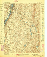
(217)- 1888 Map of Berlin
 1888 Berlin1888 Print · USGSRensselaer County at the close of the nineteenth century was a region of high ridges and narrow rail-linked valleys. Researchers can trace the path of the Lebanon Springs Railroad and locate vanished farmsteads in Barber Hollow or Mc Master Hollow.2 unique versions available
 - 1888 Map of Pittsfield
 1888 Pittsfield1888 Print · USGSThe Berkshires and eastern New York meet in this late 19th-century record of a landscape defined by communal settlements and early industry. Genealogists and historians can trace the footprint of the Canaan Shakers, industrial sites at Richmond Furnace, and the early rail stops at Edwards Station.
 - 1890 Map of Pittsfield
 1890 Pittsfield1890 Print · USGSThe Berkshires and New York borderlands are captured here in the late nineteenth century, showing a landscape defined by communal Shaker life and iron works. Researchers can trace the Lebanon Springs Railroad through Lebanon Springs or locate early industrial hubs like Richmond Furnace and Lower Barkerville.
 - 1890 Map of Berlin
 1890 Berlin1890 Print · USGSThe New York and Massachusetts borderlands in the 1880s were a landscape of steep ridges and rail-connected valley towns. Genealogists and historians can trace the old corridors of the Lebanon Springs Railroad and locate vanished family landmarks near Berlin Center, Garfield, and East Poestenkill.
 - 1893 Map of Cohoes
 1893 Cohoes1893 Print · USGSThe upper Hudson Valley and its industrial corridor come alive in the 1890s, from the streets of Cohoes to the Bemis Heights Battle Ground. Trace the original paths of the Erie Canal and Champlain Canal through Waterford and Mechanicsville.
 - 1893 Map of Troy
 1893 Troy1893 Print · USGSThe Hudson River valley at the end of the nineteenth century was a bustling hub of commerce where the Erie Canal met the Troy waterfront. Researchers can trace the early rail networks of the Boston and Albany Railroad or locate vanished sites like Schodack Depot and the industrial hamlet of Glass House.
 - 1893 Map of Coxsackie
 1893 Coxsackie1893 Print · USGSThe Hudson River valley at the close of the 19th century shows a landscape defined by waterborne trade and expanding rail networks. Genealogists and local historians can trace family-named landmarks like Stanton Hill, ferry landings at Nuttenhook, and rail hubs like Coeyman Junction.
 - 1893 Map of Pittsfield
 1893 Pittsfield1893 Print · USGSThe Berkshires and the New York border are captured here in the late nineteenth century, showing a landscape of Shaker communities and early industrial sites. Genealogists can trace family roots in Barkerville, Curtisville, and near the historic Richmond Furnace.
 - 1893 Map of Albany
 1893 Albany1893 Print · USGSThe Hudson River valley at the close of the nineteenth century reveals a complex landscape of island commerce and growing rail hubs. Genealogists and historians can trace defunct railroad stops and family-named hamlets like French Mills, Meadowdale, and The Abbey.2 unique versions available
 - 1894 Map of Berlin
 1894 Berlin1894 Print · USGSThe Rensselaer and Berkshire borderlands come alive in the late nineteenth century, showing a landscape of valley settlements and upland hollows. Trace the path of the Lebanon Springs Railroad as it connects Berlin Center, North Stephentown, and Garfield.
 - 1894 Map of Coxsackie
 1894 Coxsackie1894 Print · USGSThe Hudson River valley at the close of the 19th century was a hub of rail and river transit between Greene and Columbia counties. Genealogists can trace family names at Stanton Hill and Stephensville or locate long-lost stops like New Baltimore Sta. and Coxsackie Station.8 unique versions available
 - 1894 Map of Pittsfield
 1894 Pittsfield1894 Print · USGSThe Massachusetts and New York borderlands meet in the 1890s, where industrial villages and Shaker settlements thrive along the rail corridors. Genealogists and historians can trace family roots through communities like Canaan Shakers, Richmond Furnace, and Lower Barkerville.
 - 1895 Map of Troy
 1895 Troy1895 Print · USGSThe Hudson River valley at the close of the nineteenth century was a bustling nexus of river, rail, and canal traffic. Genealogists and historians can trace family-named hills and early hamlets from Troy to the lakes of Sand Lake, including Glass House and Sliter.
 - 1895 Map of Cohoes
 1895 Cohoes1895 Print · USGSThe Hudson and Mohawk river valleys at the end of the nineteenth century reveal a landscape shaped by canal trade and burgeoning rail lines. Genealogists and local historians can trace the early layouts of Cohoes, Mechanicville, and the historic Battle Ground at Bemis Heights.
 - 1895 Map of Albany
 1895 Albany1895 Print · USGSThe Hudson River valley and the rising Helderberg escarpment are captured here in the 1890s, revealing a landscape defined by steam-era railroads and river islands. Genealogists can trace family homesteads near Shakers, Voorheesville, and the many hamlets of Bethlehem.
 - 1897 Map of Pittsfield
 1897 Pittsfield1897 Print · USGSThe Berkshires and Columbia County come to life in the late nineteenth century as a hub of rail travel and communal living. Trace the historic Canaan Shakers settlement, find long-gone stops like Edwards Station, or study the industrial layout of Richmond Furnace.11 unique versions available
 - 1897 Map of Hoosick
 1897 Hoosick1897 Print · USGSThe Hoosic River valley and Taconic foothills thrive at the peak of the rail era in the late nineteenth century. Genealogists and historians can trace the specific layouts of Hoosick Falls, Boyntonville, and the remote hamlets of Sodom and Factory Hollow.10 unique versions available
 - 1898 Map of Albany
 1898 Albany1898 Print · USGSThe capital region in the late nineteenth century is defined by its massive rail yards and the busy Hudson riverfront. Genealogists can trace family names at Town House Corner or locate vanished landmarks like The Abbey (Gleason) and the community at Shakers.8 unique versions available
 - 1898 Map of Berlin
 1898 Berlin1898 Print · USGSRensselaer County valley towns and the Taconic highlands are captured in the late nineteenth century as the Lebanon Springs Railroad linked the region. Genealogists can trace family locations in Berlin, Stephentown, and Hancock, or find landmarks like Buckwheat Hill and Barber Hollow.10 unique versions available
 - 1898 Map of Cohoes
 1898 Cohoes1898 Print · USGSUpper Hudson Valley industry and transport are captured here at the end of the nineteenth century, from the confluence of the Mohawk to the hills of Pittstown. Trace the historic path of the Champlain Canal and the storied Battle Ground near Stillwater.8 unique versions available
 - 1898 Map of Troy
 1898 Troy1898 Print · USGSThe Hudson River valley at the turn of the century shows a bustling corridor of industry and rail before modern expansion transformed the capital region. Researchers can trace historic riverfront districts like Greenbush and Bath or locate vanished rail stops such as Schodack Depot and the Erie Canal route.8 unique versions available
 - 1899 Map of Housatonic
 1899 Housatonic1899 Print · USGSThe Berkshire hills at the close of the nineteenth century reveal a landscape of industrial hamlets and Shaker settlements. Trace the rail-and-river economy through Lenox Furnace, locate the historic Shaker Village, and find landmarks like Laura Tower.
 - 1900 Map of Taconic
 1900 Taconic1900 Print · USGSThe tri-state border region of the Taconic Mountains thrived at the turn of the century as a hub of rail travel and valley industry. Genealogists and historians can trace the early footprints of Hoosick Falls, Bennington, and the winding path of the Rutland R.R.4 unique versions available
 - 1900 Map of Housatonic
 1900 Housatonic1900 Print · USGSThe Berkshires and the Housatonic Valley are captured here at a moment of industrial and social transition during the late Victorian era. Genealogists and historians can trace the early rail networks of the Boston and Albany R.R. through old settlements like Shaker Village and Lenox Furnace.5 unique versions available
 - 1903 Map of Kinderhook
 1903 Kinderhook1903 Print · USGSColumbia County at the turn of the century shows a landscape defined by the intersection of water power and rail. Trace the industrial heritage of Stuyvesant Falls and White Mills or locate ancestral homes in Old Chatham and Valatie.6 unique versions available
Showing maps 1-25 of 217
Top cities of Rensselaer County
- Troy historical maps
- East Greenbush historical maps
- North Greenbush historical maps
- Schodack historical maps
- Brunswick historical maps
- Rensselaer historical maps
See more
Frequently asked questions
- What are the different types of historical maps available for Rensselaer County?
- What is the oldest map of Rensselaer County?
- Where can I purchase historical maps of Rensselaer County for my home or office?
- Where can I download high-res historical maps of Rensselaer County?
- Are there historical topographic maps available for Rensselaer County?
- Is there historical aerial imagery available for Rensselaer County?
- Where are historical maps of Rensselaer County sourced from?