1920s Maps of Rensselaer County, New York
Explore 5 historic maps of Rensselaer County from the 1920s. These maps offer a rare glimpse into what life looked like during the 1920s — showing old roads, neighborhoods, homes, and landmarks that have changed or disappeared over time.
Whether you're researching your family's past, planning a metal detecting trip, or studying how Rensselaer County's landscape evolved across the 1920s, these high-resolution maps are a powerful tool for exploring the history of this region.
- Focus on a specific era: All maps on this page are from the 1920s, giving you a focused view of this time period.
- See what’s changed: Compare century-old streets, trails, and buildings to today's modern landscape using overlays and satellite layers.
- Research with precision: Use these maps for genealogy, historical research, land use analysis, or educational projects.
- View, download, or print: Maps are fully viewable online in high resolution, and can be downloaded or printed for your own records.
Start exploring Rensselaer County's history through authentic maps from the 1920s. This is your window into the past.
Rensselaer County, NY maps
(5)- 1925 Map of Troy
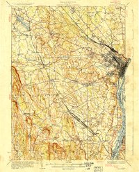
 1925 Troy1925 Print · USGSRensselaer County at the mid-twenties shows a landscape of established mill towns and developing lakefront retreats. Genealogists can trace family roots through numerous sites like St Josephs Cemetery, Teller Mill, and early schoolhouses from Albia to Hoags Corners.
 - 1927 Map of Albany
 1927 Albany1927 Print · USGSThe Albany riverfront and the Helderberg escarpment define this mid-1920s portrait of New York's capital region. Genealogists can trace a dense network of country schoolhouses and old settlements like Feura Bush, Loudonville, and the Bethlehem Church.5 unique versions available
 - 1928 Map of Troy
 1928 Troy1928 Print · USGSThe Hudson River valley at the height of its industrial era features the dense centers of Troy and Watervliet. Researchers can trace old neighborhoods near Rensselaer Polytechnic Institute or locate family plots in St Agnes Cemetery and St Marys Cemetery.5 unique versions available
 - 1929 Map of Coxsackie
 1929 Coxsackie1929 Print · USGSThe Hudson River valley in the late twenties was a bustling corridor of rail lines and river landings between Albany and Catskill. Genealogists and historians can trace family locations through dozens of numbered schoolhouses, the industrial works at Stottville, and the transit hubs of Schodack Landing and West Coxsackie.4 unique versions available
 - 1929 Map of Cohoes
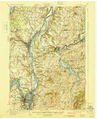 1929 Cohoes1929 Print · USGSThe industrial and revolutionary history of the Hudson Valley is clear in this late twenties survey of the river's confluence. Researchers can trace early rail stops at Stillwater Center Sta, explore the Saratoga Battlefield, or locate rural schoolhouses from School No 4 to School No 13.4 unique versions available
End of results
Showing maps 1-5 of 5
Top cities of Rensselaer County
- Troy historical maps
- East Greenbush historical maps
- North Greenbush historical maps
- Schodack historical maps
- Brunswick historical maps
- Rensselaer historical maps
See more
Frequently asked questions
- What are the different types of historical maps available for Rensselaer County?
- What is the oldest map of Rensselaer County?
- Where can I purchase historical maps of Rensselaer County for my home or office?
- Where can I download high-res historical maps of Rensselaer County?
- Are there historical topographic maps available for Rensselaer County?
- Is there historical aerial imagery available for Rensselaer County?
- Where are historical maps of Rensselaer County sourced from?