1950s Maps of Rensselaer County, New York
Explore 23 historic maps of Rensselaer County from the 1950s. These maps offer a rare glimpse into what life looked like during the 1950s — showing old roads, neighborhoods, homes, and landmarks that have changed or disappeared over time.
Whether you're researching your family's past, planning a metal detecting trip, or studying how Rensselaer County's landscape evolved across the 1950s, these high-resolution maps are a powerful tool for exploring the history of this region.
- Focus on a specific era: All maps on this page are from the 1950s, giving you a focused view of this time period.
- See what’s changed: Compare century-old streets, trails, and buildings to today's modern landscape using overlays and satellite layers.
- Research with precision: Use these maps for genealogy, historical research, land use analysis, or educational projects.
- View, download, or print: Maps are fully viewable online in high resolution, and can be downloaded or printed for your own records.
Start exploring Rensselaer County's history through authentic maps from the 1950s. This is your window into the past.
Rensselaer County, NY maps
(23)- 1950 Map of Albany
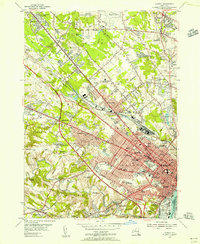
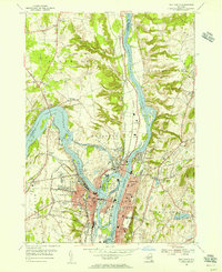
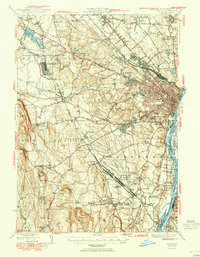 1950 Albany1950 Print · USGSMid-century Albany and its burgeoning suburbs are captured here at a peak of rail and river commerce. Genealogy and local history researchers can trace the New York Central lines to the Selkirk Yards or find family landmarks like Keefers Corners and Bethlehem Church.
 - 1950 Map of Troy
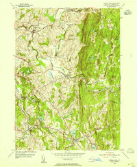
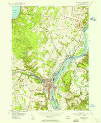
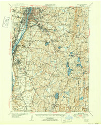 1950 Troy1950 Print · USGSThe Hudson River valley and the Rensselaer hills are shown here just after the war, capturing a landscape of dense industrial riverfronts and rural upland hamlets. Genealogists can trace family sites at Albany Rural Cemetery, identify early landmarks like Draper School No 9, or locate rail stops at East Greenbush Station.
 - 1950 Map of Taborton, 1951 Print
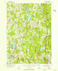
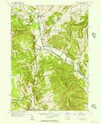
 1950 Taborton1951 Print · USGSRensselaer County’s highland lake country is captured here during a mid-century era of conservation and quiet lakeside growth. Researchers can locate vanished rural landmarks like School No 7, the historic Dutch Ch, and the grounds of Camp Kiwanis.
 - 1950 Map of Eagle Bridge, 1951 Print
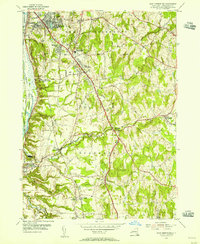
 1950 Eagle Bridge1951 Print · USGSPost-war Upstate New York comes to life along the Hoosic River valley at the Washington and Rensselaer county line. Trace family roots through rural hamlets like Eagle Bridge, Buskirk, and West Hoosick, or locate old landmarks like School No 4 and Woodside Cem.
 - 1953 Map of Delmar, 1954 Print
 1953 Delmar1954 Print · USGSThe Albany suburbs meet the industrial Hudson Valley in the early fifties, just as the New York State Thruway was being cut through the landscape. Genealogists can trace family names at Bethlehem Cem and Elmwood Cem, or explore the massive rail operations at Selkirk Yards.5 unique versions available
 - 1953 Map of Ravena, 1955 Print
 1953 Ravena1955 Print · USGSThe Hudson River valley at the dawn of the interstate era shows a landscape where historic riverfront villages meet modern infrastructure. Trace the early New York State Thruway past sites like Schodack Landing, Deans Mill, and Waldron Cem.3 unique versions available
 - 1953 Map of Nassau, 1955 Print
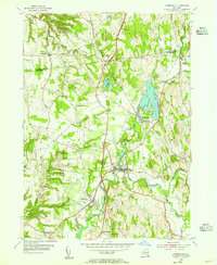
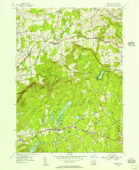
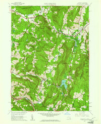
 1953 Nassau1955 Print · USGSRensselaer County in the early fifties shows a landscape of upland lakes and small crossroads settlements during a period of growing lakeside recreation. Genealogists and local historians can trace old family sites at Sliters and Hoag Corners or locate the YMCA Camp and Totem Lodge.4 unique versions available
 - 1953 Map of Kinderhook, 1955 Print
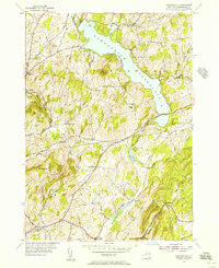
 1953 Kinderhook1955 Print · USGSColumbia County in the early fifties shows a landscape of established villages and working waterways at the height of the rail era. Genealogists can trace family footprints near the House of History, Kinderhook Lake, and Muitzes Kill.2 unique versions available
 - 1953 Map of Troy South, 1955 Print
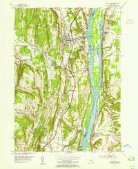
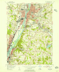 1953 Troy South1955 Print · USGSThe Hudson River industrial corridor comes alive in the early fifties, documenting the urban centers of Troy, Watervliet, and Rensselaer. Researchers can trace institutional footprints from the Watervliet Arsenal to Emma Willard College and old burial grounds like Albany Rural Cemetery.5 unique versions available
 - 1953 Map of East Chatham, 1955 Print
 1953 East Chatham1955 Print · USGSColumbia County’s rural landscape is preserved in this mid-century survey as the New York Central railroad still wound through the valley. Researchers can trace ancestral roots at The Maples Cem or locate the Shaker Museum and Riders Mills Sch in their original settings.3 unique versions available
 - 1953 Map of Averill Park, 1955 Print
 1953 Averill Park1955 Print · USGSRensselaer County townships south of Troy were a patchwork of rural villages and lakeside summer retreats in the early fifties. Genealogists and local historians can locate specific family landmarks and community hubs like St Marys Ch, Eagle Mills, and the Pawling Sanitarium.4 unique versions available
 - 1953 Map of East Greenbush, 1956 Print
 1953 East Greenbush1956 Print · USGSRensselaer County’s landscape along the Hudson is captured here in the early fifties, showing the growth of the eastern suburbs. Researchers can trace old rail stops and local infrastructure, from Van Hoesen Sta to the Red Mill Sch and the Moordener Kill.4 unique versions available
 - 1953 Map of Albany, 1956 Print
 1953 Albany1956 Print · USGSMid-century Albany and its northern suburbs are shown here just as the highway network began to reshape the capital region. Genealogists can trace family names and institutions across Graceland Cemetery, the Ann Lee Home Cem, and numerous historic campuses like the Mater Christi Seminary.3 unique versions available
 - 1954 Map of Schaghticoke, 1956 Print
 1954 Schaghticoke1956 Print · USGSIn the mid-1950s, the Hoosic River valley hummed with industry and agriculture as rail lines connected thriving villages. Genealogists and historians can trace family ties at the Little Red Schoolhouse, St Johns Ch, and Elmwood Cemetery.4 unique versions available
 - 1954 Map of Troy North, 1956 Print
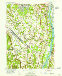
 1954 Troy North1956 Print · USGSThe industrial corridor of the upper Hudson River is captured here in the mid-1950s as a hub of rail and water transport. Genealogists can trace family names at Oakwood Cemetery or explore established neighborhoods near Crescent Station and Speigletown.4 unique versions available
 - 1954 Map of Grafton, 1956 Print
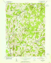
 1954 Grafton1956 Print · USGSRensselaer County’s high plateau and glacial lake country are captured here in the mid-1950s. Researchers can trace the rural legacy of the region through small hamlets like Boyntonville and local landmarks such as St Georges Ch and Cobb Sch.3 unique versions available
 - 1954 Map of North Pownal, 1956 Print
 1954 North Pownal1956 Print · USGSThe Vermont and New York border comes alive in the mid-fifties, showing the rail-linked communities of the Hoosic River valley. Genealogists and historians can trace the foundations of North Pownal, locate School No 31, and follow the Boston and Maine line through Petersburg Junction.3 unique versions available
 - 1954 Map of Tomhannock, 1956 Print
 1954 Tomhannock1956 Print · USGSRensselaer County in the mid-1950s shows a landscape shaped by the massive Tomhannock Reservoir and established rural townships. Genealogists and local historians can trace old school districts like School No 5, family cemeteries such as Maplewood Cem, and the path of the Boston and Maine railroad.2 unique versions available
 - 1954 Map of Mechanicville, 1956 Print
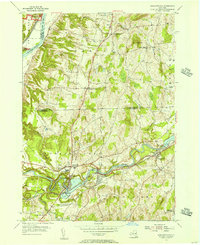
 1954 Mechanicville1956 Print · USGSMechanicville and the Upper Hudson Valley thrive as a hub of rail and water transport during the mid-fifties. Researchers can trace the path of the Champlain Canal, explore the grounds of Saratoga National Historical Park, and find family names in Hudson View Cem.4 unique versions available
 - 1956 Map of Albany, 1968 Print
 1956 Albany1968 Print · USGSThe industrial heart of the Northeast is revealed in the mid-1950s, from the Hudson Valley to the Connecticut River. Researchers can trace the legacy of the Quabbin Reservoir, locate Westover Air Force Base, or follow the Rutland RR through the Green Mountains.2 unique versions available
 - 1957 Map of Albany
 1957 Albany1957 Print · USGSThe Tri-State region and Connecticut River Valley are captured here during a period of significant postwar growth and infrastructure expansion. Genealogists and historians can trace the rail-and-river economy through landmarks like the Boston and Maine railroad, Quabbin Reservoir, and Westover Air Force Base.
 - 1959 Map of Albany
 1959 Albany1959 Print · USGSThe Hudson and Connecticut River valleys are captured here during the late fifties, showing the region's dense rail networks and massive water projects. Researchers can trace the New York State Thruway or locate local landmarks like Mt Greylock and the Quabbin Reservoir.
 - 1959 Map of Canaan, 1961 Print
 1959 Canaan1961 Print · USGSThe borderlands of New York and Massachusetts are captured here in the late fifties as rural life centered on the valleys of Canaan and New Lebanon. Genealogists and historians can trace the Cemetery of the Evergreens or the grounds of Mt Lebanon Darrow Sch.2 unique versions available
End of results
Showing maps 1-23 of 23
Top cities of Rensselaer County
- Troy historical maps
- East Greenbush historical maps
- North Greenbush historical maps
- Schodack historical maps
- Brunswick historical maps
- Rensselaer historical maps
See more
Frequently asked questions
- What are the different types of historical maps available for Rensselaer County?
- What is the oldest map of Rensselaer County?
- Where can I purchase historical maps of Rensselaer County for my home or office?
- Where can I download high-res historical maps of Rensselaer County?
- Are there historical topographic maps available for Rensselaer County?
- Is there historical aerial imagery available for Rensselaer County?
- Where are historical maps of Rensselaer County sourced from?