1930s Maps of Rockland County, New York
Explore 11 historic maps of Rockland County from the 1930s. These maps offer a rare glimpse into what life looked like during the 1930s — showing old roads, neighborhoods, homes, and landmarks that have changed or disappeared over time.
Whether you're researching your family's past, planning a metal detecting trip, or studying how Rockland County's landscape evolved across the 1930s, these high-resolution maps are a powerful tool for exploring the history of this region.
- Focus on a specific era: All maps on this page are from the 1930s, giving you a focused view of this time period.
- See what’s changed: Compare century-old streets, trails, and buildings to today's modern landscape using overlays and satellite layers.
- Research with precision: Use these maps for genealogy, historical research, land use analysis, or educational projects.
- View, download, or print: Maps are fully viewable online in high resolution, and can be downloaded or printed for your own records.
Start exploring Rockland County's history through authentic maps from the 1930s. This is your window into the past.
Rockland County, NY maps
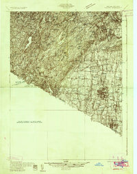
(11)- 1930 Map of Schunemunk
 1930 Schunemunk1930 Print · USGSOrange County's rail and river landscapes come into sharp focus during the late Prohibition era. Researchers can trace historic district schoolhouses like Elmwood No. 6 School and the critical junction points of the ERIE RR near Vails Gate Junction.3 unique versions available
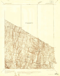
 - 1931 Map of Ramapo
 1931 Ramapo1931 Print · USGSRockland County in the late twenties and early thirties shows a unique mix of expanding suburban rail towns and state park wilderness. Genealogists and historians can trace Letchworth Village, the old Hogan Kamp Mine, and early schools like Bardonia Sch.3 unique versions available
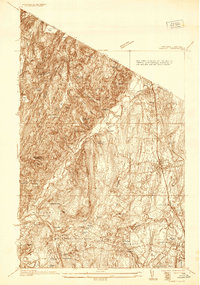
 - 1934 Map of Park Ridge
 1934 Park Ridge1934 Print · USGSBergen County settlements were evolving into distinct residential hubs during the mid-1930s. Researchers can trace early infrastructure and local landmarks like Villa Maria Clare, the Western Reservoir, and the estates of Saddle River.
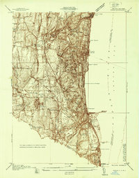
 - 1935 Map of Schunemunk
 1935 Schunemunk1935 Print · USGSOrange County in the mid-1930s is a crossroads of heavy rail and Hudson River commerce. Genealogists and historians can trace defunct rail sidings, old school sites like Quaker Hill Sch, and industrial landmarks from Bull Mine to Firthcliffe.4 unique versions available
 - 1936 Map of West Point
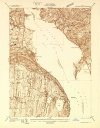
 1936 West Point1936 Print · USGSThe Hudson Highlands in the mid-1930s reveal a landscape of strategic military grounds and evolving state parks. Genealogists and historians can trace old family burial grounds like Halstead Cem, the workings of the Mahopac Mines, and the early layout of West Point.2 unique versions available
 - 1936 Map of Ramsey
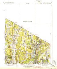
 1936 Ramsey1936 Print · USGSNorthern New Jersey during the mid-1930s shows a landscape of highland camps and expanding rail towns along the Erie RR. Trace family roots and local landmarks from Ramsey to Mahwah, including the Don Bosco Institute and Macmillan Reservoir.
 - 1937 Map of Nyack
 1937 Nyack1937 Print · USGSRockland County’s riverfront and wooded interior are shown here in the late 1930s as the rail-and-river economy remained in full swing. Genealogists and historians can trace family locations near the Rockland State Hospital, Piermont, and the St Catharines Cem.
 - 1937 Map of Tarrytown
 1937 Tarrytown1937 Print · USGSThe Hudson River valley during the 1930s serves as a busy corridor of rail, water, and infrastructure. Genealogists and local historians can trace the old landings at Waldberg Landing, the grounds of the State Prison in Ossining, and the rail lines through Nyack.
 - 1938 Map of Haverstraw
 1938 Haverstraw1938 Print · USGSThe lower Hudson River corridor comes alive in this late 1930s survey of the bustling industrial and commuter towns along the riverbanks. Researchers can trace the path of the West Shore RR, find family roots at St Peters Cem, or locate the New York Reconstruction Home.
 - 1938 Map of Ramapo
 1938 Ramapo1938 Print · USGSRockland County in the late 1930s is revealed here as a landscape of institutional campuses, rail-side villages, and emerging parklands. Genealogists can trace family connections at Letchworth Village, St Agatha Home, and vanished hamlets like Sandyfield or Johnsontown.3 unique versions available
 - 1939 Map of Park Ridge
 1939 Park Ridge1939 Print · USGSNorthwestern Bergen County and the New York state line are captured here during a period of steady suburban development along the rail lines. Trace the early layout of Montvale and Park Ridge or locate landmarks like Zion Tabernacle and Woodcliff Lake.2 unique versions available
End of results
Showing maps 1-11 of 11
Top cities of Rockland County
- Ramapo historical maps
- Clarkstown historical maps
- Orangetown historical maps
- Haverstraw historical maps
- Stony Point historical maps
- Pomona historical maps
Frequently asked questions
- What are the different types of historical maps available for Rockland County?
- What is the oldest map of Rockland County?
- Where can I purchase historical maps of Rockland County for my home or office?
- Where can I download high-res historical maps of Rockland County?
- Are there historical topographic maps available for Rockland County?
- Is there historical aerial imagery available for Rockland County?
- Where are historical maps of Rockland County sourced from?