1940s Maps of Rossie, New York
Explore 5 historic maps of Rossie from the 1940s. These maps offer a rare glimpse into what life looked like during the 1940s — showing old roads, neighborhoods, homes, and landmarks that have changed or disappeared over time.
Whether you're researching your family's past, planning a metal detecting trip, or studying how Rossie's landscape evolved across the 1940s, these high-resolution maps are a powerful tool for exploring the history of this region.
- Focus on a specific era: All maps on this page are from the 1940s, giving you a focused view of this time period.
- See what’s changed: Compare century-old streets, trails, and buildings to today's modern landscape using overlays and satellite layers.
- Research with precision: Use these maps for genealogy, historical research, land use analysis, or educational projects.
- View, download, or print: Maps are fully viewable online in high resolution, and can be downloaded or printed for your own records.
Start exploring Rossie's history through authentic maps from the 1940s. This is your window into the past.
Rossie, NY maps
(5)- 1944 Map of Hammond
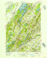
 1944 Hammond1944 Print · USGSSt. Lawrence County in the mid-1940s is a landscape of complex waterways and small rural school districts. Genealogists can trace family footprints through numerous local landmarks like Scotch Settlement Sch, the Old Iron Works, and Pope Mills.
 - 1948 Map of Ogdensburg, 1973 Print
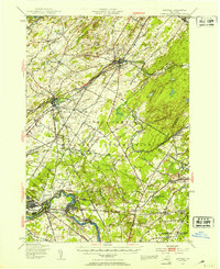
 1948 Ogdensburg1973 Print · USGSThe international border along the St Lawrence River comes to life in the late 1940s, showing the vital rail and water connections between New York and Ontario. Researchers can trace the grounds of St Lawrence University, the massive Camp Drum military reservation, and the historic Rideau River and Canal.2 unique versions available
 - 1949 Map of Hammond, 1953 Print
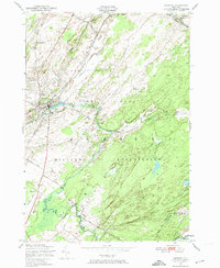
 1949 Hammond1953 Print · USGSSt. Lawrence County in the late 1940s reveals a landscape of interconnected waterways and rural school districts. Genealogists can trace family names through the Scotch Settlement Sch, Black Lake Cemetery, and the Oakvale Station rail stop.3 unique versions available
 - 1949 Map of Antwerp, 1953 Print
 1949 Antwerp1953 Print · USGSNorthern Jefferson County during the late 1940s is defined here by the massive footprint of the Pine Camp Military Reservation. You can trace rural life and ancestry through dozens of schoolhouses and family landmarks like Bishops Corners and Woods Mill.2 unique versions available
 - 1949 Map of Antwerp, 1974 Print
 1949 Antwerp1974 Print · USGSAntwerp and the surrounding North Country were undergoing a major military expansion in the late 1940s. Genealogists and historians can trace the intersection of village life and the Pine Camp Military Reservation, locating Hillside Cem and School No 15.2 unique versions available
End of results
Showing maps 1-5 of 5
Top cities near Rossie
- Le Ray historical maps
- Gouverneur historical maps
- Wilna historical maps
- Oswegatchie historical maps
- Alexandria historical maps
- Gouverneur historical maps
See more
Top neighborhoods of Rossie
- Keenes historical maps
- Nelson Corner historical maps
- Pikes Corner historical maps
- Spragueville historical maps
- Wegatchie historical maps
- Somerville historical maps
Frequently asked questions
- What are the different types of historical maps available for Rossie?
- What is the oldest map of Rossie?
- Where can I purchase historical maps of Rossie for my home or office?
- Where can I download high-res historical maps of Rossie?
- Are there historical topographic maps available for Rossie?
- Is there historical aerial imagery available for Rossie?
- Where are historical maps of Rossie sourced from?