Old Maps of Saint Lawrence County, New York
Explore 522 old maps of Saint Lawrence County, spanning from 1903 to today. These high-resolution historic maps reveal how streets, neighborhoods, landmarks, and natural features evolved over time — perfect for genealogy, metal detecting, research, and local history exploration.
What you can do with these maps:
- See how Saint Lawrence County changed over time: Compare historical maps to modern-day views to trace roads, homesites, rail lines & more.
- View detailed metadata: Each map includes creators, publishers, year, scale, and archive source.
- Overlay maps with satellite & LiDAR: Visualize the past alongside modern tools to explore terrain & human change.
- Trusted historical sources: Maps sourced from the USGS, Library of Congress, and other archives.
- Access maps your way: View online, download high-res files, or order prints for personal or research use.
Start exploring old maps of Saint Lawrence County to uncover forgotten places, hidden landmarks, and the deep history beneath your feet.
Saint Lawrence County, NY maps
(522)- 1903 Map of Alexandria Bay
 1903 Alexandria Bay1903 Print · USGSThe Thousand Islands region appears here at the turn of the century as a burgeoning summer retreat along the international border. Genealogists and local historians can trace the early layouts of Alexandria Bay, the rail corridor through Redwood, and numerous island landings like Collins Landing.6 unique versions available
 - 1904 Map of Lisbon
 1904 Lisbon1904 Print · USGSThe St. Lawrence River borderlands are captured in detail during the early 1900s, documenting the intricate islands and rapids before modern navigation projects. Trace the old riverfront at Red Mills or the rail lines of the Grand Trunk R. R. near Cardinal.
 - 1904 Map of Ogdensburg, 1957 Print
 1904 Ogdensburg1957 Print · USGSEarly 20th-century St. Lawrence County is defined here by the busy rail and river crossroads of Ogdensburg and its agricultural surroundings. Researchers can locate long-lost rural landmarks like Kings Corners Kokomo PO, the Bell Schoolhouse, and the sprawling St Lawrence State Hospital.
 - 1905 Map of Waddington
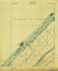
 1905 Waddington1905 Print · USGSThe international border along the St. Lawrence River is captured here in the early 1900s, before modern seaway developments altered the shoreline. Researchers can trace the original locations of Waddington, the locks of the Rapide Plat Canal, and the Grand Trunk RR rail line.5 unique versions available
 - 1905 Map of Ogdensburg
 1905 Ogdensburg1905 Print · USGSOgdensburg and the St. Lawrence River frontier are captured here in the era of steam rail and rural post offices. Local researchers can trace old family names at Northrup Cors, locate the Fish Creek Church, or follow the river to Heuvelton and the Lost Village.4 unique versions available
 - 1906 Map of Brier Hill
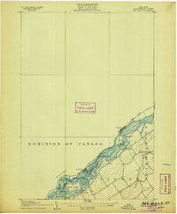
 1906 Brier Hill1906 Print · USGSThe St. Lawrence River frontier was a bustling corridor of international ferries and competing railroads at the turn of the century. You can trace the historic Steamboat Route and locate vanished river-side landmarks like Cole Ferry, Edgewater Park, and Brier Hill Sta.7 unique versions available
 - 1906 Map of Red Mills
 1906 Red Mills1906 Print · USGSThe St. Lawrence River corridor at the turn of the century shows a landscape of rapids and rail-side villages along the international border. Researchers can trace the path of the Grand Trunk R R or explore the many islands and landings near Red Mills and Iroquois.4 unique versions available
 - 1906 Map of Massena, 1956 Print
 1906 Massena1956 Print · USGSSt. Lawrence County is mapped here at the opening of the twentieth century, showcasing a landscape of powerful river rapids and vital international border crossings. Genealogists can trace early rail stations and rural hamlets like North Stockholm Knapps Sta, Massena Center, and Winthrop.
 - 1907 Map of Tupper Lake
 1907 Tupper Lake1907 Print · USGSThe Adirondack wilderness at the turn of the century shows a landscape defined by new rail lines and remote sporting clubs. Researchers can trace the early rail stops at Piercefield Sta and Childwold Sta or locate the isolated Sabattis P O and Ushers Farm.8 unique versions available
 - 1907 Map of Massena
 1907 Massena1907 Print · USGSSt. Lawrence County is depicted in the early twentieth century, showing a landscape defined by the powerful rapids of the upper river before modern dams. Researchers can trace historic river landings like Louisville Landing, the path of the Massena Power Canal, and small rail stops such as North Stockholm Knapps Sta.6 unique versions available
 - 1908 Map of Potsdam
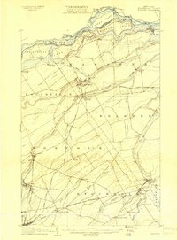
 1908 Potsdam1908 Print · USGSSt. Lawrence County is captured here in the early twentieth century as a vibrant landscape of river-powered industry and dispersed school districts. Researchers can trace the original N. Y. C. and H. R. R. R. through Norwood or locate historic rural landmarks like Browns Bridge and Old Forge School.7 unique versions available
 - 1910 Map of Canton, 1956 Print
 1910 Canton1956 Print · USGSSt. Lawrence County is captured here in the early twentieth century as a busy corridor of rail travel and river-powered industry. Researchers can locate family homesteads near Crary Mills, Langdon Corners, or the historic Brick Chapel along the Grass River.
 - 1911 Map of Canton
 1911 Canton1911 Print · USGSNorthern St. Lawrence County is captured here in the early twentieth century as a busy corridor of river-powered industry and rail transport. Genealogists and historians can trace the foundations of Canton and Potsdam or locate smaller rural hubs like Brick Chapel and Pyrites.4 unique versions available
 - 1911 Map of Antwerp
 1911 Antwerp1911 Print · USGSJefferson County was a landscape of bustling river towns and intersecting rail lines just after the turn of the century. Trace the early footprints of Antwerp and Sterlingville, or locate family landmarks like Bishops Corners and Woods Mill.6 unique versions available
 - 1912 Map of Hammond
 1912 Hammond1912 Print · USGSThe rural borderlands of St. Lawrence and Jefferson counties are captured here in the early twentieth century. Genealogists and historians can trace defunct district schools like California School and Stark School, or locate the Old Iron Works and rail stops at South Hammond Oakvale Sta.4 unique versions available
 - 1913 Map of Lake Bonaparte, 1956 Print
 1913 Lake Bonaparte1956 Print · USGSThe Lewis and Jefferson County borderlands come to life in this pre-World War I survey of the Lake Bonaparte region. Researchers can trace the old New York Central rail line past historic landmarks like Kimball Mill and the French Settlement School.
 - 1915 Map of Gouverneur
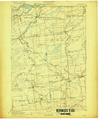
 1915 Gouverneur1915 Print · USGSSt. Lawrence County comes to life in this early twentieth-century survey of the Oswegatchie River and its surrounding rail-fed towns. Researchers can trace the legacy of rural education and industry through sites like the Fullerville Ironworks, Scotch Settlement, and Ore Bed School.4 unique versions available
 - 1915 Map of Moira, 1957 Print
 1915 Moira1957 Print · USGSNorthern New York's borderlands are captured here in the early twentieth century, showing the intersection of tribal lands and rail-driven commerce. Genealogists can trace family names and early rural life through Brasher Iron Works, Potter School, and Irish Corners.
 - 1915 Map of Russell, 1958 Print
 1915 Russell1958 Print · USGSSt. Lawrence County was a landscape of remote school districts and family-named crossroads when this survey was conducted during the First World War. Local historians can trace the foundations of the regional iron industry at the Clifton Furnace Ruins or locate vanished rural centers like Pond Settlement and Whippoorwill Corners.
 - 1916 Map of Lake Bonaparte
 1916 Lake Bonaparte1916 Print · USGSUpper New York State at the dawn of the twentieth century shows a landscape defined by isolated settlements and a budding rail network. Researchers can trace the legacy of early families and industry through sites like Kimball Mill, Natural Bridge, and the French Settlement School.5 unique versions available
 - 1916 Map of Oswegatchie
 1916 Oswegatchie1916 Print · USGSSt. Lawrence County industry and wilderness meet in the early twentieth century along the Oswegatchie River. Genealogists and historians can trace rail-tied settlements at Benson Mines, remote schools like White School, and numerous named lumber and sporting camps.3 unique versions available
 - 1917 Map of Moira
 1917 Moira1917 Print · USGSNorthern New York's borderlands come alive in the years before the Great War, showing a landscape defined by the St Regis Indian Reservation and busy rail lines. Researchers can trace family landmarks like Laverys Corner, the Brasher Iron Works, and early industrial sites like Wagstaff Factory.4 unique versions available
 - 1918 Map of Russell
 1918 Russell1918 Print · USGSSt. Lawrence County during the First World War era reveals a landscape of isolated farmsteads and rural school districts connected by winding rivers. Researchers can locate long-forgotten sites like the Clifton Furnace Ruins, the Scotland School, and the remote Pond Settlement.5 unique versions available
 - 1918 Map of Oswegatchie
 1918 Oswegatchie1918 Print · USGSThe Adirondack wilderness in the 1910s reveals a hardworking landscape of iron mines and timber camps. Genealogists and historians can trace family roots at Benson Mines, locate remote schoolhouses like White School, and follow the path of the Lumber R. R.5 unique versions available
 - 1919 Map of Nicholville, 1958 Print
 1919 Nicholville1958 Print · USGSIn the Adirondack foothills during the early twentieth century, small riverside settlements and timber camps defined local life. Genealogists can trace family footprints through numerous rural schoolhouses like Water Street School and old crossroads like Heath Hill Corners.2 unique versions available
Showing maps 1-25 of 522
Top cities of Saint Lawrence County
- Potsdam historical maps
- Massena historical maps
- Canton historical maps
- Ogdensburg historical maps
- Gouverneur historical maps
- Norfolk historical maps
See more
Frequently asked questions
- What are the different types of historical maps available for Saint Lawrence County?
- What is the oldest map of Saint Lawrence County?
- Where can I purchase historical maps of Saint Lawrence County for my home or office?
- Where can I download high-res historical maps of Saint Lawrence County?
- Are there historical topographic maps available for Saint Lawrence County?
- Is there historical aerial imagery available for Saint Lawrence County?
- Where are historical maps of Saint Lawrence County sourced from?