1980s Maps of Saint Lawrence County, New York
Explore 5 historic maps of Saint Lawrence County from the 1980s. These maps offer a rare glimpse into what life looked like during the 1980s — showing old roads, neighborhoods, homes, and landmarks that have changed or disappeared over time.
Whether you're researching your family's past, planning a metal detecting trip, or studying how Saint Lawrence County's landscape evolved across the 1980s, these high-resolution maps are a powerful tool for exploring the history of this region.
- Focus on a specific era: All maps on this page are from the 1980s, giving you a focused view of this time period.
- See what’s changed: Compare century-old streets, trails, and buildings to today's modern landscape using overlays and satellite layers.
- Research with precision: Use these maps for genealogy, historical research, land use analysis, or educational projects.
- View, download, or print: Maps are fully viewable online in high resolution, and can be downloaded or printed for your own records.
Start exploring Saint Lawrence County's history through authentic maps from the 1980s. This is your window into the past.
Saint Lawrence County, NY maps
(5)- 1982 Map of Gouverneur, 1983 Print
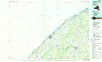
 1982 Gouverneur1983 Print · USGSSt. Lawrence County in the early eighties shows a landscape of river-driven industry and deep-rooted community infrastructure. Genealogists and local historians can trace family plots at Riverside Cem or locate industrial sites like No 3 Shaft and Natural Dam.
 - 1985 Map of Massena
 1985 Massena1985 Print · USGSNorthern New York at the mid-eighties shows a landscape of river-driven industry and high mountain wilderness along the Canadian border. Researchers can trace the legacy of iron working and milling in Brasher Iron Works or follow the Raquette River through Massena and Potsdam.
 - 1985 Map of Gouverneur
 1985 Gouverneur1985 Print · USGSSt. Lawrence and Jefferson Counties are shown in the mid-eighties as a landscape of river-driven industry and expanding military grounds. Genealogists and historians can trace rail lines through Carthage, find local landmarks like Noble Hospital, and locate the boundaries of the Fort Drum Military Reservation.2 unique versions available
 - 1985 Map of Tupper Lake, 1986 Print
 1985 Tupper Lake1986 Print · USGSThe Adirondacks in the mid-1980s reveal a network of mountain villages and timber-connected outposts. Researchers can trace the Adirondack RR through Saranac Lake or locate old industrial hamlets like Newton Falls and Gleasons Mill.2 unique versions available
 - 1985 Map of Ogdensburg, 1986 Print
 1985 Ogdensburg1986 Print · USGSThe St. Lawrence River valley and the northern New York borderlands are shown here in the mid-1980s, during a period of established institutional and collegiate growth. Researchers can trace the paths of CONRAIL through Potsdam or locate local landmarks like Mater Dei College and Rensselaer Falls.2 unique versions available
End of results
Showing maps 1-5 of 5
Top cities of Saint Lawrence County
- Potsdam historical maps
- Massena historical maps
- Canton historical maps
- Ogdensburg historical maps
- Gouverneur historical maps
- Norfolk historical maps
See more
Frequently asked questions
- What are the different types of historical maps available for Saint Lawrence County?
- What is the oldest map of Saint Lawrence County?
- Where can I purchase historical maps of Saint Lawrence County for my home or office?
- Where can I download high-res historical maps of Saint Lawrence County?
- Are there historical topographic maps available for Saint Lawrence County?
- Is there historical aerial imagery available for Saint Lawrence County?
- Where are historical maps of Saint Lawrence County sourced from?