1900-1909 Maps of Saint Lawrence County, New York
Explore 11 historic maps of Saint Lawrence County from 1900-1909. These maps offer a rare glimpse into what life looked like during the 1900s — showing old roads, neighborhoods, homes, and landmarks that have changed or disappeared over time.
Whether you're researching your family's past, planning a metal detecting trip, or studying how Saint Lawrence County's landscape evolved across the 1900s, these high-resolution maps are a powerful tool for exploring the history of this region.
- Focus on a specific era: All maps on this page are from the 1900s, giving you a focused view of this time period.
- See what’s changed: Compare century-old streets, trails, and buildings to today's modern landscape using overlays and satellite layers.
- Research with precision: Use these maps for genealogy, historical research, land use analysis, or educational projects.
- View, download, or print: Maps are fully viewable online in high resolution, and can be downloaded or printed for your own records.
Start exploring Saint Lawrence County's history through authentic maps from the 1900s. This is your window into the past.
Saint Lawrence County, NY maps
(11)- 1903 Map of Alexandria Bay
 1903 Alexandria Bay1903 Print · USGSThe Thousand Islands region appears here at the turn of the century as a burgeoning summer retreat along the international border. Genealogists and local historians can trace the early layouts of Alexandria Bay, the rail corridor through Redwood, and numerous island landings like Collins Landing.6 unique versions available
 - 1904 Map of Lisbon
 1904 Lisbon1904 Print · USGSThe St. Lawrence River borderlands are captured in detail during the early 1900s, documenting the intricate islands and rapids before modern navigation projects. Trace the old riverfront at Red Mills or the rail lines of the Grand Trunk R. R. near Cardinal.
 - 1904 Map of Ogdensburg, 1957 Print
 1904 Ogdensburg1957 Print · USGSEarly 20th-century St. Lawrence County is defined here by the busy rail and river crossroads of Ogdensburg and its agricultural surroundings. Researchers can locate long-lost rural landmarks like Kings Corners Kokomo PO, the Bell Schoolhouse, and the sprawling St Lawrence State Hospital.
 - 1905 Map of Waddington
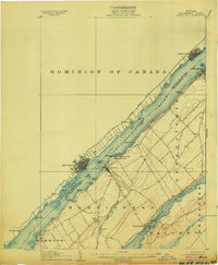
 1905 Waddington1905 Print · USGSThe international border along the St. Lawrence River is captured here in the early 1900s, before modern seaway developments altered the shoreline. Researchers can trace the original locations of Waddington, the locks of the Rapide Plat Canal, and the Grand Trunk RR rail line.5 unique versions available
 - 1905 Map of Ogdensburg
 1905 Ogdensburg1905 Print · USGSOgdensburg and the St. Lawrence River frontier are captured here in the era of steam rail and rural post offices. Local researchers can trace old family names at Northrup Cors, locate the Fish Creek Church, or follow the river to Heuvelton and the Lost Village.4 unique versions available
 - 1906 Map of Brier Hill
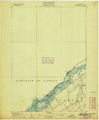
 1906 Brier Hill1906 Print · USGSThe St. Lawrence River frontier was a bustling corridor of international ferries and competing railroads at the turn of the century. You can trace the historic Steamboat Route and locate vanished river-side landmarks like Cole Ferry, Edgewater Park, and Brier Hill Sta.7 unique versions available
 - 1906 Map of Red Mills
 1906 Red Mills1906 Print · USGSThe St. Lawrence River corridor at the turn of the century shows a landscape of rapids and rail-side villages along the international border. Researchers can trace the path of the Grand Trunk R R or explore the many islands and landings near Red Mills and Iroquois.4 unique versions available
 - 1906 Map of Massena, 1956 Print
 1906 Massena1956 Print · USGSSt. Lawrence County is mapped here at the opening of the twentieth century, showcasing a landscape of powerful river rapids and vital international border crossings. Genealogists can trace early rail stations and rural hamlets like North Stockholm Knapps Sta, Massena Center, and Winthrop.
 - 1907 Map of Tupper Lake
 1907 Tupper Lake1907 Print · USGSThe Adirondack wilderness at the turn of the century shows a landscape defined by new rail lines and remote sporting clubs. Researchers can trace the early rail stops at Piercefield Sta and Childwold Sta or locate the isolated Sabattis P O and Ushers Farm.8 unique versions available
 - 1907 Map of Massena
 1907 Massena1907 Print · USGSSt. Lawrence County is depicted in the early twentieth century, showing a landscape defined by the powerful rapids of the upper river before modern dams. Researchers can trace historic river landings like Louisville Landing, the path of the Massena Power Canal, and small rail stops such as North Stockholm Knapps Sta.6 unique versions available
 - 1908 Map of Potsdam
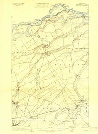
 1908 Potsdam1908 Print · USGSSt. Lawrence County is captured here in the early twentieth century as a vibrant landscape of river-powered industry and dispersed school districts. Researchers can trace the original N. Y. C. and H. R. R. R. through Norwood or locate historic rural landmarks like Browns Bridge and Old Forge School.7 unique versions available
End of results
Showing maps 1-11 of 11
Top cities of Saint Lawrence County
- Potsdam historical maps
- Massena historical maps
- Canton historical maps
- Ogdensburg historical maps
- Gouverneur historical maps
- Norfolk historical maps
See more
Frequently asked questions
- What are the different types of historical maps available for Saint Lawrence County?
- What is the oldest map of Saint Lawrence County?
- Where can I purchase historical maps of Saint Lawrence County for my home or office?
- Where can I download high-res historical maps of Saint Lawrence County?
- Are there historical topographic maps available for Saint Lawrence County?
- Is there historical aerial imagery available for Saint Lawrence County?
- Where are historical maps of Saint Lawrence County sourced from?