1920s Maps of Saint Lawrence County, New York
Explore 7 historic maps of Saint Lawrence County from the 1920s. These maps offer a rare glimpse into what life looked like during the 1920s — showing old roads, neighborhoods, homes, and landmarks that have changed or disappeared over time.
Whether you're researching your family's past, planning a metal detecting trip, or studying how Saint Lawrence County's landscape evolved across the 1920s, these high-resolution maps are a powerful tool for exploring the history of this region.
- Focus on a specific era: All maps on this page are from the 1920s, giving you a focused view of this time period.
- See what’s changed: Compare century-old streets, trails, and buildings to today's modern landscape using overlays and satellite layers.
- Research with precision: Use these maps for genealogy, historical research, land use analysis, or educational projects.
- View, download, or print: Maps are fully viewable online in high resolution, and can be downloaded or printed for your own records.
Start exploring Saint Lawrence County's history through authentic maps from the 1920s. This is your window into the past.
Saint Lawrence County, NY maps
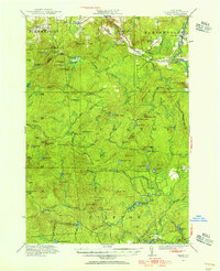
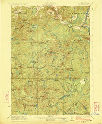
(7)- 1920 Map of Childwold, 1954 Print
 1920 Childwold1954 Print · USGSIn the Adirondack interior during the early 1920s, this area showcases a network of timber camps and early sporting clubs. Researchers can trace the riverfront development of Hollywood and Childwold, or locate landmarks like the Shur-leff Hotel and Kildare.2 unique versions available
 - 1921 Map of Cranberry Lake
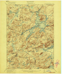 1921 Cranberry Lake1921 Print · USGSIn the early 1920s, this area of the Adirondacks was a nexus of wilderness and industry, from the waters of Cranberry Lake to the iron operations at Benson Mines. Researchers can trace the early grounds of the State Ranger School and follow the New York Central RR through Wanakena.7 unique versions available
 - 1921 Map of Childwold
 1921 Childwold1921 Print · USGSThe Adirondack wilderness in the early twenties was a landscape of remote sporting clubs and isolated river outposts. Genealogists and historians can trace old homesteads and landmarks like the Shurtleff Hotel, Childwold School, and the long-vanished community of Hollywood.
 - 1921 Map of Nicholville
 1921 Nicholville1921 Print · USGSUpper St. Lawrence and Franklin counties come alive in the early twentieth century as a landscape of timber-driven river towns and rural school districts. Genealogists can trace family footprints near St Regis Falls, Dickinson Center, and numerous rural sites like Harper School or Joe Indian.4 unique versions available
 - 1921 Map of Stark, 1956 Print
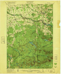
 1921 Stark1956 Print · USGSSt. Lawrence County in the early twenties shows a landscape shaped by logging and the Adirondack wilderness. Researchers can trace the path of the Lumber RR, locate early rural sites like Glendale Mill and Cold Brook School, or find the secluded Stillwater Club.2 unique versions available
 - 1922 Map of Childwold
 1922 Childwold1922 Print · USGSThe St. Lawrence County wilderness in the early twenties is a landscape of isolated camps and early Adirondack outposts. Local historians can locate vanished sites like the Shurtleff Hotel or trace the early foundations of Childwold and Hollywood near the Jordan River.4 unique versions available
 - 1923 Map of Stark
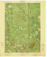
 1923 Stark1923 Print · USGSSt. Lawrence County was a landscape of remote lumbering outposts and river-fed settlements in the early 1920s. Genealogists and historians can trace old homesteads at Sellecks Cors, follow the path of the Lumber RR, and locate the Irish Settlement.4 unique versions available
End of results
Showing maps 1-7 of 7
Top cities of Saint Lawrence County
- Potsdam historical maps
- Massena historical maps
- Canton historical maps
- Ogdensburg historical maps
- Gouverneur historical maps
- Norfolk historical maps
See more
Frequently asked questions
- What are the different types of historical maps available for Saint Lawrence County?
- What is the oldest map of Saint Lawrence County?
- Where can I purchase historical maps of Saint Lawrence County for my home or office?
- Where can I download high-res historical maps of Saint Lawrence County?
- Are there historical topographic maps available for Saint Lawrence County?
- Is there historical aerial imagery available for Saint Lawrence County?
- Where are historical maps of Saint Lawrence County sourced from?