1930s Maps of Northumberland, New York
Explore 4 historic maps of Northumberland from the 1930s. These maps offer a rare glimpse into what life looked like during the 1930s — showing old roads, neighborhoods, homes, and landmarks that have changed or disappeared over time.
Whether you're researching your family's past, planning a metal detecting trip, or studying how Northumberland's landscape evolved across the 1930s, these high-resolution maps are a powerful tool for exploring the history of this region.
- Focus on a specific era: All maps on this page are from the 1930s, giving you a focused view of this time period.
- See what’s changed: Compare century-old streets, trails, and buildings to today's modern landscape using overlays and satellite layers.
- Research with precision: Use these maps for genealogy, historical research, land use analysis, or educational projects.
- View, download, or print: Maps are fully viewable online in high resolution, and can be downloaded or printed for your own records.
Start exploring Northumberland's history through authentic maps from the 1930s. This is your window into the past.
Northumberland, NY maps
(4)- 1934 Map of Quaker Springs
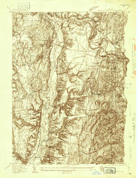
 1934 Quaker Springs1934 Print · USGSSaratoga County was a landscape of busy rail lines and storied ridges in the 1930s. Researchers can trace the legacy of the Saratoga Battlefield or locate vanished local landmarks like Stafford Bridge and Quaker Ch.
 - 1935 Map of Gansevoort
 1935 Gansevoort1935 Print · USGSSaratoga County in the mid-1930s reveals a landscape of rural crossroads and specialized institutions between the mountains and the river. Genealogists and local historians can trace family-named hubs like Travers Corners, the Mt McGregor Sanatorium, and several rural schools.
 - 1935 Map of Schuylerville
 1935 Schuylerville1935 Print · USGSThe Hudson River valley around Schuylerville and Greenwich is mapped here in the mid-1930s, showing the early evolution of the Saratoga region's industrial and historic landscape. Genealogists and historians can locate family landmarks like Rafferty Sch, the St Josephs Cem, and the now-quiet Champlain Canal (Abandoned).
 - 1935 Map of Fort Miller
 1935 Fort Miller1935 Print · USGSThe Hudson River and its engineering works dominate this mid-1930s landscape along the border of Washington and Saratoga counties. Genealogists can locate family landmarks like Ellis Farm or trace ancestors through Fort Miller Cem and the numerous rural schoolhouses such as Argyle Sch.
End of results
Showing maps 1-4 of 4
Top cities near Northumberland
- Queensbury historical maps
- Saratoga Springs historical maps
- Milton historical maps
- Wilton historical maps
- Malta historical maps
- Moreau historical maps
See more
Top neighborhoods of Northumberland
- Jewell Corner historical maps
- Bacon Hill historical maps
- Starks Knob historical maps
- Gansevoort historical maps
Frequently asked questions
- What are the different types of historical maps available for Northumberland?
- What is the oldest map of Northumberland?
- Where can I purchase historical maps of Northumberland for my home or office?
- Where can I download high-res historical maps of Northumberland?
- Are there historical topographic maps available for Northumberland?
- Is there historical aerial imagery available for Northumberland?
- Where are historical maps of Northumberland sourced from?