1960s Maps of Saratoga, New York
Explore 3 historic maps of Saratoga from the 1960s. These maps offer a rare glimpse into what life looked like during the 1960s — showing old roads, neighborhoods, homes, and landmarks that have changed or disappeared over time.
Whether you're researching your family's past, planning a metal detecting trip, or studying how Saratoga's landscape evolved across the 1960s, these high-resolution maps are a powerful tool for exploring the history of this region.
- Focus on a specific era: All maps on this page are from the 1960s, giving you a focused view of this time period.
- See what’s changed: Compare century-old streets, trails, and buildings to today's modern landscape using overlays and satellite layers.
- Research with precision: Use these maps for genealogy, historical research, land use analysis, or educational projects.
- View, download, or print: Maps are fully viewable online in high resolution, and can be downloaded or printed for your own records.
Start exploring Saratoga's history through authentic maps from the 1960s. This is your window into the past.
Saratoga, NY maps
(3)- 1964 Map of Glens Falls
 1964 Glens Falls1964 Print · USGSThe tri-state borderlands of New York, Vermont, and New Hampshire appear here in the mid-1960s. Researchers can trace the rail routes of the Rutland RR and find historic sites like Ticonderoga and Saratoga National Historical Park.
 - 1967 Map of Quaker Springs, 1970 Print
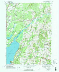 1967 Quaker Springs1970 Print · USGSSaratoga County in the late sixties reveals a landscape of Revolutionary War landmarks and lakeside hamlets. Trace the edges of Saratoga National Historical Park and locate historic crossroads like Quaker Springs and Wayville.2 unique versions available
 - 1967 Map of Schuylerville, 1970 Print
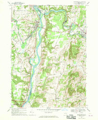 1967 Schuylerville1970 Print · USGSThe Hudson River valley and the industrial corridor of the Batten Kill are captured here in the late sixties. Genealogists and local historians can trace family-named routes like Hanehan Rd and landmarks including Victory Mills and Starks Knob.
End of results
Showing maps 1-3 of 3
Top cities near Saratoga
- Clifton Park historical maps
- Queensbury historical maps
- Saratoga Springs historical maps
- Halfmoon historical maps
- Niskayuna historical maps
- Milton historical maps
See more
Top neighborhoods of Saratoga
- Burgoyne historical maps
- Deans Corners historical maps
- Quaker Springs historical maps
- Saratoga Lake historical maps
- Cedar Bluffs historical maps
- Coveville historical maps
See more
Frequently asked questions
- What are the different types of historical maps available for Saratoga?
- What is the oldest map of Saratoga?
- Where can I purchase historical maps of Saratoga for my home or office?
- Where can I download high-res historical maps of Saratoga?
- Are there historical topographic maps available for Saratoga?
- Is there historical aerial imagery available for Saratoga?
- Where are historical maps of Saratoga sourced from?