1950s Maps of Schenectady County, New York
Explore 13 historic maps of Schenectady County from the 1950s. These maps offer a rare glimpse into what life looked like during the 1950s — showing old roads, neighborhoods, homes, and landmarks that have changed or disappeared over time.
Whether you're researching your family's past, planning a metal detecting trip, or studying how Schenectady County's landscape evolved across the 1950s, these high-resolution maps are a powerful tool for exploring the history of this region.
- Focus on a specific era: All maps on this page are from the 1950s, giving you a focused view of this time period.
- See what’s changed: Compare century-old streets, trails, and buildings to today's modern landscape using overlays and satellite layers.
- Research with precision: Use these maps for genealogy, historical research, land use analysis, or educational projects.
- View, download, or print: Maps are fully viewable online in high resolution, and can be downloaded or printed for your own records.
Start exploring Schenectady County's history through authentic maps from the 1950s. This is your window into the past.
Schenectady County, NY maps
(13)- 1950 Map of Binghamton
 1950 Binghamton1950 Print · USGSBinghamton and the surrounding Southern Tier are shown in the mid-century era, highlighting the intricate rail and river networks that drove local industry. Researchers can trace the path of the Erie Railroad and locate landmarks from Otsego Lake to Sidney Mountain.2 unique versions available
 - 1954 Map of Duanesburg, 1956 Print
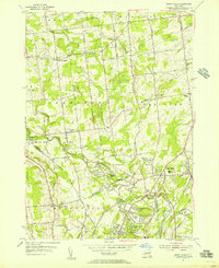
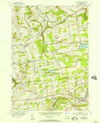 1954 Duanesburg1956 Print · USGSSchenectady and Montgomery counties are captured in the mid-fifties, showing a landscape of upland farms and historic crossroads. Genealogists can trace family names through dozens of small burial sites like Ryderdell Cem or locate the Duane Mansion and Sky Haven Airport.3 unique versions available
 - 1954 Map of Niskayuna, 1956 Print
 1954 Niskayuna1956 Print · USGSThe Mohawk River valley in the mid-1950s shows the shifting landscape of upstate New York as suburban growth meets traditional canal routes. Trace the old waterway path through Vischer Ferry, locate family plots at Most Holy Redeemer Cemetery, or explore the early layout of Albany Municipal Airport.4 unique versions available
 - 1954 Map of Rotterdam Junction, 1956 Print
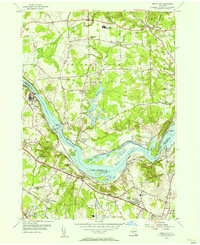
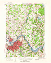
 1954 Rotterdam Junction1956 Print · USGSSchenectady County in the mid-fifties shows the busy convergence of the Mohawk River and the then-new New York State Thruway. You can trace the path of the Erie Canal (Abandoned) and locate local landmarks like Gay Valley Air Park and Princetown Ch.4 unique versions available
 - 1954 Map of Pattersonville, 1956 Print
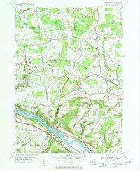 1954 Pattersonville1956 Print · USGSThe Mohawk River valley near Pattersonville was a bustling corridor of rail and water transit in the mid-1950s. Researchers can trace family history through sites like Woestina Cem and early landmarks like the abandoned Erie Canal and Hoffmans.2 unique versions available
 - 1954 Map of Amsterdam, 1956 Print
 1954 Amsterdam1956 Print · USGSMid-century Amsterdam and the Mohawk Valley are shown here in their industrial prime, centered on a busy river-and-rail corridor. Researchers can trace the layout of vanished neighborhood schools like Milton Avenue Sch or locate ancestors at Green Hill Cemetery and St Marys Cem.4 unique versions available
 - 1954 Map of Burnt Hills, 1956 Print
 1954 Burnt Hills1956 Print · USGSThe Saratoga and Schenectady county borderlands show a blend of rural hamlets and post-war suburban growth during the mid-1950s. Trace the evolution of Burnt Hills, East Glenville, and Charlton, or locate vanished schoolhouses like Industrial Farm Sch.5 unique versions available
 - 1954 Map of Schenectady, 1957 Print
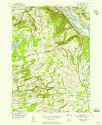
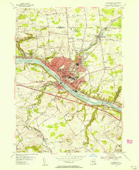
 1954 Schenectady1957 Print · USGSSchenectady and the Mohawk River valley appear here at a mid-century peak of industrial and military activity. Researchers can trace historic family burial sites at Vale Cemetery, follow the old Erie Canal, or locate vanished neighborhoods near the U S Mil Res Schenectady General Depot.4 unique versions available
 - 1954 Map of Schenectady, 1957 Print
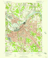
 1954 Schenectady1957 Print · USGSThe Mohawk Valley's industrial and transit networks are in full view at mid-century, from the rail yards of Schenectady to the waters of the Erie Canal. Genealogists can locate legacy sites like Vischer Ferry, Pine Grove Cem, and numerous rural schoolhouses.
 - 1956 Map of Albany, 1968 Print
 1956 Albany1968 Print · USGSThe industrial heart of the Northeast is revealed in the mid-1950s, from the Hudson Valley to the Connecticut River. Researchers can trace the legacy of the Quabbin Reservoir, locate Westover Air Force Base, or follow the Rutland RR through the Green Mountains.2 unique versions available
 - 1957 Map of Albany
 1957 Albany1957 Print · USGSThe Tri-State region and Connecticut River Valley are captured here during a period of significant postwar growth and infrastructure expansion. Genealogists and historians can trace the rail-and-river economy through landmarks like the Boston and Maine railroad, Quabbin Reservoir, and Westover Air Force Base.
 - 1958 Map of Binghamton
 1958 Binghamton1958 Print · USGSCentral New York in the late fifties was a network of manufacturing cities and river valleys connected by vital rail lines. Genealogists and historians can trace family roots in Oneonta, Norwich, and Cooperstown or locate long-standing farms along Schoharie Creek.
 - 1959 Map of Albany
 1959 Albany1959 Print · USGSThe Hudson and Connecticut River valleys are captured here during the late fifties, showing the region's dense rail networks and massive water projects. Researchers can trace the New York State Thruway or locate local landmarks like Mt Greylock and the Quabbin Reservoir.
End of results
Showing maps 1-13 of 13
Top cities of Schenectady County
- Schenectady historical maps
- Rotterdam historical maps
- Glenville historical maps
- Niskayuna historical maps
- Duanesburg historical maps
- Princetown historical maps
See more
Frequently asked questions
- What are the different types of historical maps available for Schenectady County?
- What is the oldest map of Schenectady County?
- Where can I purchase historical maps of Schenectady County for my home or office?
- Where can I download high-res historical maps of Schenectady County?
- Are there historical topographic maps available for Schenectady County?
- Is there historical aerial imagery available for Schenectady County?
- Where are historical maps of Schenectady County sourced from?