
Loading...
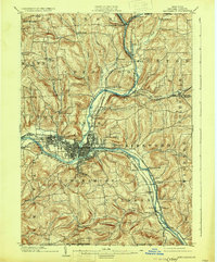
Loading map...1950 Map of Binghamton
USGS Topo · Published 1950About this map
The Susquehanna River and its numerous tributaries carve through the heart of the Southern Tier and Central New York on this 1950 Army Map Service survey. Major rail corridors like the Erie Railroad and the New York, Ontario and Western Railway define the industrial and transit patterns of the era, connecting Binghamton and Oneonta to the wider region. In the northeast, the Mohawk River corridor passes through Amsterdam, while the northern reaches of the Catskill Mountains dominate the southeastern landscape.
Find a feature on this map
220 named features on this map. Tap any name to fly to it.
Don’t see what you’re looking for? This feature index may not catch every label — zoom into the map to look around manually.
Map Details
Date Portrayed1950
Date Published1950
PublisherU.S. Geological Survey
Map TypeTopographic
Scale1:250,000
Physical Dimensions34.5 x 24.1 inches
Editions of this 1950 Binghamton Map
2 editions found

Historical Maps of Union Through Time
6 maps found


Featured Locations
Source Details
SourceU.S. Geological Survey
CopyrightPublic Domain