1940s Maps of Carlisle, New York
Explore 12 historic maps of Carlisle from the 1940s. These maps offer a rare glimpse into what life looked like during the 1940s — showing old roads, neighborhoods, homes, and landmarks that have changed or disappeared over time.
Whether you're researching your family's past, planning a metal detecting trip, or studying how Carlisle's landscape evolved across the 1940s, these high-resolution maps are a powerful tool for exploring the history of this region.
- Focus on a specific era: All maps on this page are from the 1940s, giving you a focused view of this time period.
- See what’s changed: Compare century-old streets, trails, and buildings to today's modern landscape using overlays and satellite layers.
- Research with precision: Use these maps for genealogy, historical research, land use analysis, or educational projects.
- View, download, or print: Maps are fully viewable online in high resolution, and can be downloaded or printed for your own records.
Start exploring Carlisle's history through authentic maps from the 1940s. This is your window into the past.
Carlisle, NY maps
(12)- 1943 Map of Cobleskill, 1954 Print
 1943 Cobleskill1954 Print · USGSSchoharie County's rugged valley and rail corridor are captured here during the 1940s, anchored by the town of Cobleskill. Genealogists and historians can locate specific sites like the State Agricultural School, Howe Caverns, and the Lawyer Cem.4 unique versions available
 - 1943 Map of Sharon Springs, 1955 Print
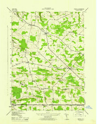
 1943 Sharon Springs1955 Print · USGSSchoharie and Montgomery Counties are captured in detail during the early 1940s, showing a landscape of upland farms and rural crossroads. Genealogists can locate family landmarks like Flanders Cem, the Dutch Reformed Ch, and small settlements such as Mapletown (Blaine) and Argusville.3 unique versions available
 - 1943 Map of Carlisle, 1957 Print
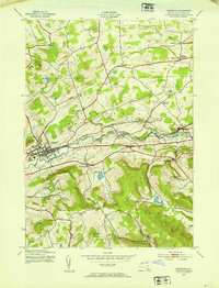
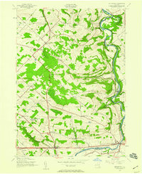
 1943 Carlisle1957 Print · USGSUpper Montgomery and Schoharie counties appear here during the mid-forties, characterized by a dense network of upland farms and crossroads hamlets. Researchers can locate numerous local landmarks like Charleston Four Corners, Gove Cem, and the Cherry Valley Turnpike.2 unique versions available
 - 1943 Map of Schoharie, 1959 Print
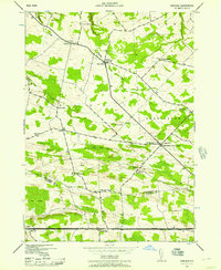
 1943 Schoharie1959 Print · USGSThe Schoharie Valley was a vital rail and river corridor during the mid-forties, defined by its small farming hamlets and prominent terrain. Researchers can trace ancestral roots through the Old Stone Fort, several rural schoolhouses, and cemeteries like St Pauls Cem and Central Bridge Cem.4 unique versions available
 - 1943 Map of Esperance, 1959 Print
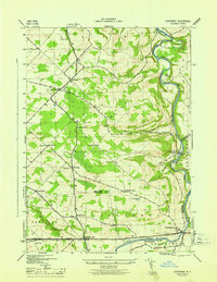
 1943 Esperance1959 Print · USGSThe rural borderlands of Montgomery and Schoharie counties appear here during the mid-forties, showing a landscape of scattered crossroads and winding waterways. Family historians can locate family-named landmarks like Kimball Cem and Rockwell Corners or trace old school districts like Carytown Sch.2 unique versions available
 - 1944 Map of Richmondville, 1960 Print
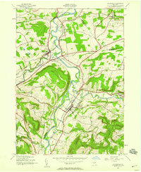
 1944 Richmondville1960 Print · USGSSchoharie County was a landscape of rail-connected villages and hillside farmsteads in the mid-1940s. Genealogists can trace the location of local institutions and families through labels for St Johns Ch, Peoples Cem, and several district schools like School No 12.4 unique versions available
 - 1945 Map of Cobleskill
 1945 Cobleskill1945 Print · USGSSchoharie County in the mid-1940s is defined by its railroad valley and early tourist attractions. Researchers can trace family plots like Guernsey Cem, find the original State Agricultural School site, and locate Howe Caverns and Secret Caverns.
 - 1945 Map of Carlisle
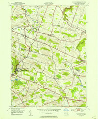
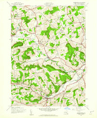
 1945 Carlisle1945 Print · USGSMid-century Montgomery and Schoharie Counties appear as a landscape of crossroads hamlets and country schools just after the war. You can trace early family sites like Lykers Cem or follow the historic path of the CHERRY VALLEY TURNPIKE through Carlisle.
 - 1945 Map of Richmondville
 1945 Richmondville1945 Print · USGSSchoharie County's agricultural valleys and upland hamlets are captured here at the end of the Second World War. Researchers can trace dozens of rural landmarks, from St Johns Church and Beekman Corners to specific 1940s schoolhouses like School No 8 and School No 3.
 - 1946 Map of Schoharie
 1946 Schoharie1946 Print · USGSThe Schoharie Valley in the mid-1940s remains a landscape of river-bottom farms and rural schoolhouses. Genealogists can trace family roots at St Pauls Cem or locate the site of Old Central Bridge and the Old Stone Fort.
 - 1946 Map of Esperance
 1946 Esperance1946 Print · USGSThe Montgomery and Schoharie County borderlands appear here in the mid-1940s, just as the rural school system and turnpike network remained central to local life. You can trace old property sites near Sloansville, Charleston, and family burials at the Kimball Cem.
 - 1948 Map of Binghamton, 1980 Print
 1948 Binghamton1980 Print · USGSCentral New York and the Southern Tier thrive in the late 1940s as a hub of rail traffic and mountain industry. Researchers can trace historic transit lines like the Erie Railroad through Binghamton or find old valley settlements near Oneonta and Delhi.
End of results
Showing maps 1-12 of 12
Top cities near Carlisle
- Amsterdam historical maps
- Cobleskill historical maps
- Duanesburg historical maps
- Amsterdam historical maps
- Cobleskill historical maps
- Minden historical maps
See more
Top neighborhoods of Carlisle
- Carlisle Center historical maps
- Grovenor Corners historical maps
- Argusville historical maps
- Little York historical maps
Frequently asked questions
- What are the different types of historical maps available for Carlisle?
- What is the oldest map of Carlisle?
- Where can I purchase historical maps of Carlisle for my home or office?
- Where can I download high-res historical maps of Carlisle?
- Are there historical topographic maps available for Carlisle?
- Is there historical aerial imagery available for Carlisle?
- Where are historical maps of Carlisle sourced from?