1940s Maps of Richmondville, New York
Explore 11 historic maps of Richmondville from the 1940s. These maps offer a rare glimpse into what life looked like during the 1940s — showing old roads, neighborhoods, homes, and landmarks that have changed or disappeared over time.
Whether you're researching your family's past, planning a metal detecting trip, or studying how Richmondville's landscape evolved across the 1940s, these high-resolution maps are a powerful tool for exploring the history of this region.
- Focus on a specific era: All maps on this page are from the 1940s, giving you a focused view of this time period.
- See what’s changed: Compare century-old streets, trails, and buildings to today's modern landscape using overlays and satellite layers.
- Research with precision: Use these maps for genealogy, historical research, land use analysis, or educational projects.
- View, download, or print: Maps are fully viewable online in high resolution, and can be downloaded or printed for your own records.
Start exploring Richmondville's history through authentic maps from the 1940s. This is your window into the past.
Richmondville, NY maps
(11)- 1943 Map of Cobleskill, 1954 Print
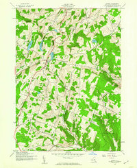
 1943 Cobleskill1954 Print · USGSSchoharie County's rugged valley and rail corridor are captured here during the 1940s, anchored by the town of Cobleskill. Genealogists and historians can locate specific sites like the State Agricultural School, Howe Caverns, and the Lawyer Cem.4 unique versions available
 - 1943 Map of South Valley, 1954 Print
 1943 South Valley1954 Print · USGSOtsego County's rural townships are captured here in the 1940s, showing a landscape of small hamlets and highland farms. Genealogists can trace family roots through several schools and cemeteries, from School No 9 to Maple View Cem and Gothicville.4 unique versions available
 - 1943 Map of Breakabeen, 1959 Print
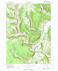 1943 Breakabeen1959 Print · USGSSchoharie County in the 1940s is captured here in the transition from traditional valley farming to modern rural life. Genealogists can trace family homes near Vintonton, locate the Fulton Hill Cem, or explore the riverside layout of Breakabeen.5 unique versions available
 - 1943 Map of Summit, 1960 Print
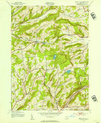
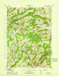
 1943 Summit1960 Print · USGSSchoharie County uplands are captured here in the mid-1940s, showing a rural landscape of distributed schoolhouses and family cemeteries. Researchers can locate numerous local landmarks including Fairland Ch, Eminence, and the waters of Summit Lake.4 unique versions available
 - 1944 Map of Richmondville, 1960 Print
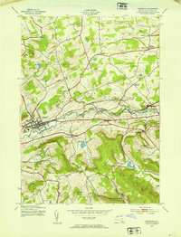
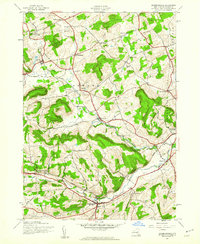 1944 Richmondville1960 Print · USGSSchoharie County was a landscape of rail-connected villages and hillside farmsteads in the mid-1940s. Genealogists can trace the location of local institutions and families through labels for St Johns Ch, Peoples Cem, and several district schools like School No 12.4 unique versions available
 - 1945 Map of Cobleskill
 1945 Cobleskill1945 Print · USGSSchoharie County in the mid-1940s is defined by its railroad valley and early tourist attractions. Researchers can trace family plots like Guernsey Cem, find the original State Agricultural School site, and locate Howe Caverns and Secret Caverns.
 - 1945 Map of South Valley
 1945 South Valley1945 Print · USGSCentral New York’s borderlands in the mid-1940s reveal a network of isolated upland hamlets and family cemeteries. Trace the legacy of small communities like Gothicville and South Valley alongside burial grounds such as Ferris Cem and Dorloo Cem.
 - 1945 Map of Summit
 1945 Summit1945 Print · USGSSchoharie County's upland ridges and rural hollows are captured here during the mid-forties, showing the region's dense network of district schools and remote settlements. Researchers can trace family history through local landmarks like Fairland Ch, Rossman Cem, and ten numbered schoolhouses including Cross Hill Sch.
 - 1945 Map of Richmondville
 1945 Richmondville1945 Print · USGSSchoharie County's agricultural valleys and upland hamlets are captured here at the end of the Second World War. Researchers can trace dozens of rural landmarks, from St Johns Church and Beekman Corners to specific 1940s schoolhouses like School No 8 and School No 3.
 - 1946 Map of Breakabeen
 1946 Breakabeen1946 Print · USGSSchoharie County in the mid-1940s is captured here in a transition between its agricultural past and forested future. Researchers can trace family sites from Housons Corners to West Fulton, or locate remote landmarks like Fulton Hill Cem and Boucks Falls.
 - 1948 Map of Binghamton, 1980 Print
 1948 Binghamton1980 Print · USGSCentral New York and the Southern Tier thrive in the late 1940s as a hub of rail traffic and mountain industry. Researchers can trace historic transit lines like the Erie Railroad through Binghamton or find old valley settlements near Oneonta and Delhi.
End of results
Showing maps 1-11 of 11
Top cities near Richmondville
- Cobleskill historical maps
- Cobleskill historical maps
- Minden historical maps
- Canajoharie historical maps
- Middleburgh historical maps
- Schoharie historical maps
See more
Top neighborhoods of Richmondville
Frequently asked questions
- What are the different types of historical maps available for Richmondville?
- What is the oldest map of Richmondville?
- Where can I purchase historical maps of Richmondville for my home or office?
- Where can I download high-res historical maps of Richmondville?
- Are there historical topographic maps available for Richmondville?
- Is there historical aerial imagery available for Richmondville?
- Where are historical maps of Richmondville sourced from?