1890s Maps of Hector, New York
Explore 3 historic maps of Hector from the 1890s. These maps offer a rare glimpse into what life looked like during the 1890s — showing old roads, neighborhoods, homes, and landmarks that have changed or disappeared over time.
Whether you're researching your family's past, planning a metal detecting trip, or studying how Hector's landscape evolved across the 1890s, these high-resolution maps are a powerful tool for exploring the history of this region.
- Focus on a specific era: All maps on this page are from the 1890s, giving you a focused view of this time period.
- See what’s changed: Compare century-old streets, trails, and buildings to today's modern landscape using overlays and satellite layers.
- Research with precision: Use these maps for genealogy, historical research, land use analysis, or educational projects.
- View, download, or print: Maps are fully viewable online in high resolution, and can be downloaded or printed for your own records.
Start exploring Hector's history through authentic maps from the 1890s. This is your window into the past.
Hector, NY maps
(3)- 1893 Map of Ithaca, 1960 Print
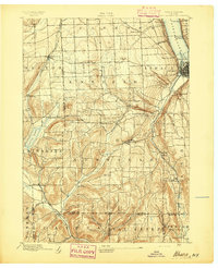
 1893 Ithaca1960 Print · USGSThe Finger Lakes region at the end of the nineteenth century was a landscape of steep gorges and rail-connected hamlets. Genealogists and local historians can trace old property lines and rural crossroads from Ithaca to Trumbull Corner and the secluded Pony Hollow.
 - 1895 Map of Ithaca
 1895 Ithaca1895 Print · USGSThe Finger Lakes region at the end of the nineteenth century is defined by its dramatic lakefront topography and rural hamlets. Genealogists and historians can trace family locations across Ithaca, Newfield, and the high reaches of Connecticut Hill.13 unique versions available
 - 1898 Map of Watkins Glen, 1961 Print
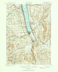 1898 Watkins Glen1961 Print · USGSSteamboat routes and competing rail lines define the Schuyler County landscape at the close of the nineteenth century. Researchers can trace the early rail stops at Rock Stream Station, the heights of Watkins Hill, and vanished post offices like Barnes P. O.
End of results
Showing maps 1-3 of 3
Top cities near Hector
- Ithaca historical maps
- Lansing historical maps
- Milo historical maps
- Newfield historical maps
- Ulysses historical maps
- Dix historical maps
See more
Top neighborhoods of Hector
- Bennettsburg historical maps
- Searsburg historical maps
- East Steamburg historical maps
- Perry City historical maps
- Logan historical maps
- Hector Falls Point historical maps
See more
Frequently asked questions
- What are the different types of historical maps available for Hector?
- What is the oldest map of Hector?
- Where can I purchase historical maps of Hector for my home or office?
- Where can I download high-res historical maps of Hector?
- Are there historical topographic maps available for Hector?
- Is there historical aerial imagery available for Hector?
- Where are historical maps of Hector sourced from?